South Milwaukee, Wisconsin | |
---|---|
Motto: Proud past. Promising future. | |
Coordinates: 42°54′40″N87°51′51″W / 42.91111°N 87.86417°W Coordinates: 42°54′40″N87°51′51″W / 42.91111°N 87.86417°W | |
Country | United States |
State | Wisconsin |
County | Milwaukee |
Area | |
• Total | 4.84 sq mi (12.53 km2) |
• Land | 4.83 sq mi (12.51 km2) |
• Water | 0.01 sq mi (0.02 km2) |
Elevation | 669 ft (204 m) |
Population | |
• Total | 20,795 |
• Estimate (2021) [4] | 20,517 |
• Density | 4,285.77/sq mi (1,654.89/km2) |
Time zone | UTC−6 (Central (CST)) |
• Summer (DST) | UTC−5 (CDT) |
ZIP code | 53172 [5] |
Area code | 414 |
FIPS code | 55-75125 [6] |
GNIS feature ID | 1574469 [2] |
Website | southmilwaukee |
South Milwaukee is a city in Milwaukee County, Wisconsin, United States. The population was 20,795 at the 2020 census.
South Milwaukee was laid out in 1891 by the South Milwaukee company within the Town of Oak Creek, with the purpose of serving as a rival industrial suburb of the City of Milwaukee, [7] and was named from its location south of Milwaukee. [8] South Milwaukee was incorporated as a village in 1892, [7] then as a city in 1897. [9] South Milwaukee has a rich immigrant history, as immigrants from England and Germany made up a large portion of the population in the early 1900s. [10]
South Milwaukee is located at 42°54′40″N87°51′51″W / 42.91111°N 87.86417°W (42.911016, −87.864030). [11]
According to the United States Census Bureau, the city has a total area of 4.81 square miles (12.46 km2), of which, 4.80 square miles (12.43 km2) is land and 0.01 square miles (0.03 km2) is water. [12]
Historical population | |||
---|---|---|---|
Census | Pop. | %± | |
1900 | 3,392 | — | |
1910 | 6,092 | 79.6% | |
1920 | 7,598 | 24.7% | |
1930 | 10,706 | 40.9% | |
1940 | 11,134 | 4.0% | |
1950 | 12,855 | 15.5% | |
1960 | 20,307 | 58.0% | |
1970 | 23,297 | 14.7% | |
1980 | 21,069 | −9.6% | |
1990 | 20,958 | −0.5% | |
2000 | 21,256 | 1.4% | |
2010 | 21,156 | −0.5% | |
2020 | 20,795 | −1.7% | |
2021 (est.) | 20,517 | [4] | −1.3% |
U.S. Decennial Census |
As of the census [13] of 2010, there were 21,156 people, 9,043 households, and 5,475 families living in the city. The population density was 4,407.5 inhabitants per square mile (1,701.7/km2). There were 9,722 housing units at an average density of 2,025.4 per square mile (782.0/km2). The racial makeup of the city was 91.6% White, 2.0% African American, 0.8% Native American, 1.1% Asian, 2.1% from other races, and 2.2% from two or more races. Hispanic or Latino of any race were 8.0% of the population.
There were 9,043 households, of which 28.5% had children under the age of 18 living with them, 43.3% were married couples living together, 11.9% had a female householder with no husband present, 5.4% had a male householder with no wife present, and 39.5% were non-families. 32.8% of all households were made up of individuals, and 12.7% had someone living alone who was 65 years of age or older. The average household size was 2.31 and the average family size was 2.93.
The median age in the city was 40.3 years. 21.8% of residents were under the age of 18; 8.4% were between the ages of 18 and 24; 26% were from 25 to 44; 28.1% were from 45 to 64; and 15.6% were 65 years of age or older. The gender makeup of the city was 49.0% male and 51.0% female.
As of the census [6] of 2000, there were 21,256 people, 8,694 households, and 5,616 families living in the city. The population density was 4,447.5 people per square mile (1,716.9/km2). There were 9,122 housing units at an average density of 1,908.6 per square mile (736.8/km2). The racial makeup of the city was 94.81% White, 1.04% African American, 0.58% Native American, 0.69% Asian, 0.04% Pacific Islander, 1.36% from other races, and 1.47% from two or more races. Hispanic or Latino of any race were 4.01% of the population.
There were 8,694 households, out of which 30.2% had children under the age of 18 living with them, 49.8% were married couples living together, 10.7% had a female householder with no husband present, and 35.4% were non-families. 30.1% of all households were made up of individuals, and 11.2% had someone living alone who was 65 years of age or older. The average household size was 2.40 and the average family size was 3.00.
In the city, the population was spread out, with 23.9% under the age of 18, 8.0% from 18 to 24, 30.3% from 25 to 44, 21.1% from 45 to 64, and 16.6% who were 65 years of age or older. The median age was 38 years. For every 100 females, there were 94.5 males. For every 100 females age 18 and over, there were 91.9 males.
The median income for a household in the city was $44,197, and the median income for a family was $54,474. Males had a median income of $38,146 versus $27,121 for females. The per capita income for the city was $20,925. About 4.5% of families and 6.0% of the population were below the poverty line, including 7.5% of those under age 18 and 6.6% of those age 65 or over.
South Milwaukee was the headquarters of Bucyrus International, formerly Bucyrus-Erie, which is known for constructing large shovels and dragline excavators, including Big Muskie, the world's largest mobile earth-moving machine. Bucyrus shovels were used in the construction of the Panama Canal.
In November 2012 Caterpillar Mining bought Bucyrus International for $8.6 billion and will make a goal to become a "one-stop shop" for mining companies worldwide. [14]
Within South Milwaukee's borders is Grant Park, part of the Milwaukee County Park System. Grant Park features the Oak Leaf Bike trail, tennis courts, a swimming beach, an 18-hole golf course and the Seven Bridges Hiking Trail along the shore of Lake Michigan.
In 2005, the South Milwaukee Performing Arts Center was built adjacent to the new South Milwaukee High School. This Performing Arts Center, which is open to the public, hosts a variety of entertainment.
South Milwaukee was served by passenger rail until 1971, via the South Milwaukee Passenger Station. Today, the former depot is listed on the National Register of Historic Places. Freight railroad services are provided by the Union Pacific Railroad.
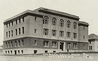
Adams County is a county in the U.S. state of North Dakota. As of the 2020 census, the population was 2,200. The county seat is Hettinger. The county was created on April 17, 1907, and organized one week later. It was named for John Quincy Adams (1848–1919), a railroad official for the Milwaukee Road Railroad and distant relative of sixth U.S. President John Quincy Adams (1767–1848).
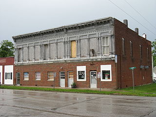
Crawford County is a county located in the north central portion of the U.S. state of Ohio. As of the 2020 census, the population was 42,025. Its county seat and largest city is Bucyrus. The county was created in 1820 and later organized in 1836. It was named for Colonel William Crawford, a soldier during the American Revolution.
New Florence is a city in Montgomery County, Missouri, United States. The population was 641 at the 2020 census.
Bucyrus is a city in Adams County, North Dakota, United States. The population was 18 at the 2020 census.
Bucyrus is a city in the U.S. state of Ohio and the county seat of Crawford County, located in northern Ohio approximately 28 miles (45 km) west of Mansfield and 66 miles (106 km) southeast of Toledo. The population was 11,684 at the 2020 census. The city is the largest in Crawford County, and the center of the Bucyrus Micropolitan Statistical Area.
New Lisbon is a city in Juneau County, Wisconsin, United States. The population was 1,748 at the 2020 census.
Maribel is a village in Manitowoc County, Wisconsin, United States. The population was 351 at the 2010 census.
Cudahy is a city in Milwaukee County, Wisconsin, United States. The population was 18,204 at the 2020 census.
Glendale is a city in Milwaukee County, Wisconsin, United States. It is a suburb of the neighboring Milwaukee. The population was 13,357 at the 2020 census.
Greenfield is a city in the U.S. state of Wisconsin. Located in Milwaukee County, Greenfield is one of many bedroom communities in the Milwaukee metropolitan area. The population was 37,803 as of the 2020 Census.
Oak Creek is a city in the U.S. state of Wisconsin. Located in Milwaukee County, it sits on the southwestern shore of Lake Michigan and is located immediately south of Milwaukee. The city is one of the fastest growing in Milwaukee County and all of Wisconsin. As of the 2020 census the population was 36,497.
St. Francis is a city in Milwaukee County, Wisconsin, United States. The population was 9,161 at the 2020 census.
West Milwaukee is a village in Milwaukee County, Wisconsin, United States, which is located in the center of the county approximately a mile south of American Family Field. The population was 4,114 at the 2020 census.
Nashotah is a village in Waukesha County, Wisconsin, United States. The population was 1,321 at the 2020 census. The village took its name from the nearby Nashotah Lakes.
Newburg is a village in Ozaukee and Washington Counties in the U.S. state of Wisconsin. The population was 1,254 at the 2010 census. Of this, 1,157 were in Washington County, and only 97 were in Ozaukee County.
Adams is a city in Adams County in the U.S. state of Wisconsin. The population was 1,967 at the 2010 census. The city is located within the Town of Adams.
Stockbridge is a village in Calumet County, Wisconsin, United States. The population was 686 at the 2020 census. The village lies within the Town of Stockbridge.
Boscobel is a city in Grant County, Wisconsin, United States. The population was 3,286 at the 2020 census. Approximately 0.6 mi. (1 km) to the north of the city, across a riparian swamp, is the Wisconsin River. U.S. Route 61 crosses the Wisconsin River at Boscobel. To the south, the city is bordered by the Town of Boscobel.
Clinton is a village in Rock County, Wisconsin, United States. The population was 2,221 at the 2020 census. The village is located within the town of Clinton. The Norwegian-American Jefferson Prairie Settlement was located near the village.
Pewaukee is a city in Waukesha County, Wisconsin. The population was 13,195 at the 2010 census. The Village of Pewaukee, which was incorporated out of the town before it incorporated as a city, is surrounded by the city.