Parks in Milwaukee County park system
The Milwaukee County Park system was awarded the 2009 National Gold Medal Award "for excellence in the field of park and recreation management" by the National Recreation and Park Association. [1] [2] [3] [4]
| Park | Address | Size | Notes | Photo |
|---|---|---|---|---|
| Alcott | 3751 S 97 St | 16.9-acre (68,000 m2) | | |
| Algonquin | 7850 N 51 St | 9.4-acre (38,000 m2) | This park, located in Brown Deer, Wisconsin, has historically been a neighborhood park. Located adjacent to Algonquin Elementary School (now demolished), Algonquin Park is the home of a playground and wading pool. | |
| Armour | 6105 W Norwich Ave | 14.6-acre (59,000 m2) | | |
| Atkinson | 936 W Atkinson Ave | 1.3-acre (5,300 m2) | ||
| Back Bay | 2315 E Back Bay | 6.5-acre (26,000 m2) | Overlooks Lake Michigan | |
| Baran | 2600 S Chase Ave | 23.8-acre (96,000 m2) | Baran Park has primarily been a baseball park, housing several ball diamonds. Nestled between the freeway and the neighborhoods of Bay View, Baran Park has provided a quiet island adjacent to several highly populated areas on Milwaukee's south side. |  |
| Barnard | 3300 W Barnard Ave | 10.1-acre (41,000 m2) | Adjacent to Greenfield Middle School |  |
| Bay View | 3120 S Lake Dr | 37.5-acre (152,000 m2) |  | |
| Beckum | 900 W. Brown St | |||
| Bender | 4503 E Ryan Rd | 302.7-acre (1,225,000 m2) | ||
| Big Bay | 5000 N Lake Dr | 8.7-acre (35,000 m2) | ||
| Bradford | 2400 N Lincoln Memorial Dr | 29.0-acre (117,000 m2) | Beach volleyball courts along Lake Michigan |  |
| Brown Deer | 7835 N Green Bay Rd | 362.6-acre (1,467,000 m2) | Location of the Brown Deer Park Golf Course and since 1994, the U.S. Bank Championship. Golf course designed by George Hansen in 1929. | |
| Burns Commons | 1300 N Franklin Pl | 1.5-acre (6,100 m2) | The original site (called "First Ward Triangle") was donated to the City of Milwaukee by a real estate developer named James H. Rogers in 1847, making it one of the oldest parks in the city. The city soon changed the name to Franklin Park, the later renamed the park in honor of Scottish poet Robert Burns, to whom there is statue. [5] | |
| Butterfly | 37th and Meinecke Ave | |||
| Caesar's | 1939 N Warren Ave | 3.7-acre (15,000 m2) | Southern end of the "east bank trail" on the East Side, adjacent to the east bank of the Milwaukee River and the former North Avenue dam. Site was originally acquired by the City of Milwaukee Water Department in 1889 and was named Milwaukee River Dam Park. In 1929, it was transferred to the city's parks department and named Caesar's Park in honor of Caesar Paikowski. [6] In 1997, the city of Milwaukee removed the central section of the North Avenue dam, allowing the water to flow faster. [7] |  |
| Cambridge Woods | Cambridge & Providence | 20.9-acre (85,000 m2) | Located in Milwaukee's East Side neighborhood, west of University of Wisconsin–Milwaukee, along the Milwaukee River. |  |
| Cannon | 303 N 95 St | 8.5-acre (34,000 m2) | ||
| Carver | 911 W Brown St | 23.2-acre (94,000 m2) | A portion of the current site has a history of park use which dates back to 1853. At that point in time, Quentin's Park, a private facility, occupied the site of what is now Roosevelt Middle School plus much of the southerly part of Carver Park. In 1879 this land was sold to the Joseph Schlitz Brewing Company and Schlitz Park (a popular beer garden) was created. [8] Through the 1940s, the park was called Lapham Park [9] and featured the Lapham Memorial. | |
| Cathedral Square | 520 E Wells St | 2.1-acre (8,500 m2) | The exact site of Milwaukee's second courthouse (1873–1931), as well as neighboring land to the first courthouse, which was just north of the park. [10] Next to St. John's Cathedral and location of "Jazz in the Park," an outdoor summer concert series. | |
| Center Street | 6420 W Clarke St | 4.5-acre (18,000 m2) | ||
| Chippewa | 11500 Park Hill Ave | 10.5-acre (42,000 m2) | ||
| Clarke Square | 2330 W Vieau Pl | 2.1-acre (8,500 m2) | Donated in 1837 by Nathaniel Brown and Norman and Lydia Clarke, who at the time were real estate developers in the area. [8] | |
| Clas | 930 W Wells St | 1.0-acre (4,000 m2) | Located adjacent to the south entrance of the Milwaukee County Courthouse. The Park Commission acquired the land (which had been a parking lot) from the County Board in 1967. A fountain was added during redevelopment of the space in the 1980s. The park was named after Alfred C. Clas, a prominent architect and planner who also served as a County Park Commissioner (1907–1917) [11] |  |
| Columbus, Indigenous Peoples' | 7301 W Courtland Ave | 10.4-acre (42,000 m2) | ||
| Cooper | 8701 W Chambers St | 8.4-acre (34,000 m2) | Named for William H. Cooper who served as a member of the Milwaukee County Parks Commission from 1948 to 1955, the park contains a rental pavilion, softball diamonds, a play structure, and a wading pool. The Friends of Cooper Park partner with the county for park improvements, volunteer activities, and community events. [12] |  |
| Copernicus | 2150 W Klein Ave | 20.3-acre (82,000 m2) | ||
| Cudahy | 3000 E Ramsey Ave | 17.6-acre (71,000 m2) | ||
| Cudahy Nature Preserve | 501 E College Ave | 42.2-acre (171,000 m2) | ||
| Cupertino | 2000 E Iron St | 7.1-acre (29,000 m2) | Named after County Supervisor Daniel Cupertino, this area was previously the northernmost portion of Southshore Park. |   |
| Currie | 3535 N Mayfair Rd | 195.7-acre (792,000 m2) | Golf course designed by George Hansen in 1927. | |
| Dineen | 6901 W Vienna Ave | 64.2-acre (260,000 m2) | Located on the northwest side of Milwaukee, the park land was first acquired in 1951, with major developments in the 1960s. Named in honor of Cornelius R. Dineen, Park Commissioner (1927–1955). [13] | |
| Doctors | 1870 E Fox Ln | 54.8-acre (222,000 m2) | Overlooks Lake Michigan; adjoins Schlitz Audubon Nature Center | |
| Doyne | 5300 W Wells St | 35.4-acre (143,000 m2) | ||
| Dretzka | 12020 W Bradley Rd | 326.0-acre (1,319,000 m2) | The majority of park land was acquired in 1956. The park was named after Jerome C. Dretzka, a member of the Park Commission (1920–1963). The 210-acre (0.85 km2) golf course opened in 1964. Other facilities include a golf driving range, picnic areas, sand volleyball, a multi-use athletic field, a disc golf course, a segment of the Oak Leaf Trail, and a groomed cross-country ski trail. [14] | |
| Estabrook | 4400 N Estabrook Dr | 122.0-acre (494,000 m2) | Located along the easterly bank of the Milwaukee River between Hampton Ave and Capitol Drive. Initial acquisition of land for the park started in 1916. Significant development took place in the early and mid-1930s, led in part by the Civilian Conservation Corps. The historic Benjamin Church House—built by pioneer builder Benjamin F. Church—was moved to the park in 1938. [15] The WITI TV Tower is also located within the park. |  |
| Euclid | 3200 S 88 St | 9.1-acre (37,000 m2) |  | |
| Falk | 2013 W Rawson Ave | 215.8-acre (873,000 m2) | ||
| Franklin | 10400 W Oakwood Rd | 164.5-acre (666,000 m2) | ||
| Froemming | 8801 S 51 St | 16.9-acre (68,000 m2) | ||
| Garden Homes Square | 2600 W Atkinson Ave | 1.8-acre (7,300 m2) | ||
| Gilman Triangle | 2475 N Lake Dr | 0.4-acre (1,600 m2) | ||
| Gordon | 2828 N Humboldt Blvd | 25.0-acre (101,000 m2) | The City of Milwaukee purchased the site for Gordon Park in 1907. In 1937, it was turned over to Milwaukee County as part of the consolidation of parks. [16] | |
| Grant | 100 E Hawthorne Ave | 379.3-acre (1,535,000 m2) | Located in South Milwaukee, established in 1911 after Horace Fowle's sale of farm land. [17] |  |
| Granville Dog Park | 11718 W Good Hope Pl | 25.4-acre (103,000 m2) | Milwaukee County's first dog park. Established in 1998, Granville Dog Park sits in what was once the town of Granville before it was annexed by the City of Milwaukee. Originally created by a combination of political leaders and a non-profit group, Partners in Parks, Granville Dog Park is now run exclusively by the Milwaukee County Parks department. | |
| Greene | 4235 S Lipton Ave | 36.5-acre (148,000 m2) | ||
| Greenfield Park | 2028 S 124 St @ W Greenfield Ave | 282.3-acre (1,142,000 m2) | Located in West Allis at the source of both the Root River and Underwood Creek. The majority of land for the park was acquired in 1921. The golf course, designed by George Hansen, opened in 1923. The park's pool became the county's first outdoor swimming pool when it opened in 1932. [18] |  |
| Grobschmidt | 3751 W College Ave | 152.0-acre (615,000 m2) | Composed of oak-hickory woodland, sedge meadow, and a six-acre pond named Mud Lake. Formerly used by Native Americans and is virtually undeveloped except for the park sign and walking trail. |   |
| Hales Corners | 5765 S New Berlin Rd | 33.1-acre (134,000 m2) | ||
| Hansen | 9800 W Underwood Creek Pkwy | 51.4-acre (208,000 m2) | ||
| A.C. Hanson | 9100 N Maura Ln | 13.5-acre (55,000 m2) | This small park in Brown Deer houses a great playground. | |
| Hart | 7300 Chestnut Street Wauwatosa, WI 53213 | 19.5-acre (79,000 m2) | ||
| Hartung | 3266 Menomonee River Parkway Wauwatosa, WI 53222 | .28-acre (1,100 m2) | ||
| Hawthorne Glen | 1130 North 60th Street | 23-acre (93,000 m2) | Nature center museum, live native animals, ¾ mile self-guided nature trail, picnic areas | |
| Highland | 4000 W Highland Blvd | 3.4-acre (14,000 m2) | ||
| Holler | 5151 S 6 St | 15.4-acre (62,000 m2) | ||
| Holt | 3300 S 106 St | 20.6-acre (83,000 m2) | Undeveloped park located in Greenfield. |  |
| Hoyt | 1800 Swan Blvd | 20.0-acre (81,000 m2) | ||
| Humboldt | 3000 S Howell Ave | 70.2-acre (284,000 m2) | One of the city's first parks, opened in 1891. In 1900, it was named to honor Friedrich Wilhelm Heinrich Alexander Freiherr von Humboldt. [19] |  |
| Jackson | 3500 W Forest Home Ave | 113.0-acre (457,000 m2) | First named Reynolds Grove in 1907, renamed in honor of Andrew Jackson in 1910. The park contains the Statue of Commerce or "The Pewter Lady." This statue by sculptor Gustav Haug had originally stood over the entrance of the Chamber of Commerce building in downtown from 1880 until 1909. [20] |  |
| Jacobus | 6501 W Hillside Ln | 26.0-acre (105,000 m2) | The original name of the site was Sholes Park in honor of Christopher Sholes. In 1932, the site was renamed in recognition of the role Charles C. Jacobus, a former county supervisor from Wauwatosa, had in development of the park system. [21] | |
| Johnsons | 1919 W Fond du Lac Ave | 13.2-acre (53,000 m2) | ||
| Johnstone | 6750 S 24 St | 12.7-acre (51,000 m2) | ||
| Joseph Lichter | N Swan Rd & W Fairy Chasm Dr | 33.7-acre (136,000 m2) | ||
| Juneau | 801 N Lincoln Memorial Dr | 15.8-acre (64,000 m2) | Named after Solomon Juneau. Overlooks Lake Michigan just north of downtown. Originally under the jurisdiction of the public works department. The original park was a narrow strip of land along the bluff above a busy railroad depot. [8] |  |
| Kern | 3614 N Humboldt Blvd | 30.2-acre (122,000 m2) | ||
| King | 1531 W Vliet St | 21.4-acre (87,000 m2) | Named after Martin Luther King Jr. The County Park Commission acquired park land in 1968 from the City of Milwaukee redevelopment agency. The community center opened in 1976, which continued to provide a range of programming. [22] | |
| Kinnickinnic Sports Center | 3070 S 20 St | 20.0-acre (81,000 m2) | ||
| Kletzsch | 6560 N Milw. River Pkwy | 140.5-acre (569,000 m2) | Adjacent to the Milwaukee River within the City of Glendale. Acquisition of land for the park began in 1918 when the 35-acre (140,000 m2) Blatz farm was purchased. Named after Alvin P. Kletzsch, a member of the Park Commission (1907–1941). Archaeological studies done in the early 1930s indicated that a portion of the park once contained an Indian camp and burial ground. [23] | |
| Kohl | 7603 W County Line Rd | 273.2-acre (1,106,000 m2) | Named after real estate developer, Sydney Kohl, this land was donated to Milwaukee County but has become undeveloped thus far. Previous to being named the land was called Park Site 71. An effort to explore development of the property was torpedoed by neighbors adjacent to the park in 2000 amid fears of what development could bring. | |
| Kops | 3321 N 86 St | 8.2-acre (33,000 m2) | Named in honor of Milwaukee County Supervisor, Gerald Henry Kops, the park is located near Mount Mary College. Attorney Kops received his undergraduate degree from NYU and his law degree from Marquette University. He served as Milwaukee County Supervisor for over 20 years in the 1930s nd 1940's. The park includes a wading pool, tot lot and 2 softball diamonds. | |
| Kosciuszko | 2201 S 7 St | 33.6-acre (136,000 m2) | The city acquired initial land in 1890 from J. C. Coleman, and the site was referred to as the Coleman Tract and Coleman Park. During the mid-1890s the site was renamed Lincoln Avenue Park and ultimately in 1900 it was named after General Tadeusz Kościuszko, to which there is a statue. [24] |  |
| Kulwicki | 10777 W Coldspring Rd | 28.2-acre (114,000 m2) | Created in 1996 to honor NASCAR racecar driver, and Greenfield native, Alan Kulwicki |  |
| La Follette | 9418 W Washington St | 18.4-acre (74,000 m2) | ||
| Lake | 3233 E Kenwood Blvd | 138.1-acre (559,000 m2) | Designed by Frederick Law Olmsted. Location of the historic North Point Lighthouse, which was built in 1855. |  |
| Lincoln | 1301 W Hampton Ave | 312.3-acre (1,264,000 m2) | Location of the television station transmitter tower for WISN-TV and the combined tower of Weigel Broadcasting's four area stations. | |
| Lindbergh | 3629 N 16 St | 3.0-acre (12,000 m2) | ||
| Lindsay | 4360 N 87 St | 13.3-acre (54,000 m2) | ||
| Lyons | 3301 S 55 St | 12.4-acre (50,000 m2) | | |
| Madison | 9800 W Glendale Ave | 59.1-acre (239,000 m2) | ||
| Maitland | 6001 S 13 St | 26.9-acre (109,000 m2) | ||
| Manitoba | 2941 S 49 St | 3.7-acre (15,000 m2) |  | |
| McCarty | 8214 W Cleveland Ave | 52.1-acre (211,000 m2) | Located in West Allis. A segment of the Oak Leaf Trail cuts through this park. | |
| McGovern | 5400 N 51 Blvd | 61.0-acre (247,000 m2) | Initially called Silver Spring Park, later renamed in honor of William R. McGovern, the longest serving Park Commissioner (1919–1964). Initial acquisition of the land took place in 1910 when the Milwaukee County Board of Supervisors purchased acreage as part of the House of Corrections farm which was located in that area. [25] | |
| McKinley | 1750 N Lincoln Memorial Dr | 103.3-acre (418,000 m2) | ||
| Meaux | 1904 W Villard Ave | 25.8-acre (104,000 m2) | ||
| Melody View Preserve | 7300 N 91 St | 13.9-acre (56,000 m2) | Prior to acquisition by Milwaukee County, this land was owned by MPS who sold the land to Walgreens who wanted to put a pharmacy on Good Hope Road. Amid neighborhood concerns, the County Supervisor at the time negotiated donation of the land between Walgreens and the Melody View Neighborhood. A walking path which was planned of the park was scrapped amid budget concerns in the late 1990s. | |
| Merrill | 461 N 35 St | 11.47-acre (46,400 m2) | ||
| Metcalfe | 3401 W. Meinecke Ave | |||
| Mitchell | 524 S Layton Blvd | 61.0-acre (247,000 m2) | Location of the Mitchell Park Horticultural Conservatory. |  |
| Mitchell Airport | 4446 S Logan Ave | 18.8-acre (76,000 m2) | Located just north of Milwaukee Mitchell International Airport. | |
| Mitchell Boulevard | 5115 W Bluemound Rd | 15.6-acre (63,000 m2) | The Tree of Life is at the North end of the park along Bluemound Rd. | |
| Moody | 2200 W Burleigh St | 4.1-acre (17,000 m2) | ||
| Morgan Triangle | 3404 S Kinnickinnic Ave | 0.9-acre (3,600 m2) | ||
| Nash | 7800 W Nash St | 9.3-acre (38,000 m2) | ||
| Noyes | 8235 W Good Hope Rd | 71.6-acre (290,000 m2) | Housing a par 3 golf course, Noyes Park is a short course on Milwaukee's Northwest side. It also houses a great playground on the western part of the park. | |
| Oakwood | 3600 W Oakwood Rd | 276.0-acre (1,117,000 m2) | Initial acquisition of land for the park occurred in 1958, the rest was purchased by 1961. The 18-hole golf course (opened in 1971) occupies over one-half of the park and it is the county's longest course at approximately 7,000 yards. [26] | |
| O'Donnell Park | E. Wisconsin Avenue & Prospect | 9.3-acre (38,000 m2) | Has views of the lakefront and downtown skyline from benches and picnic tables. Home to the Betty Brinn Children's Museum, banquet facilities and plaza gardens used for weddings and other events. The park links the east end of Wisconsin Avenue and the "Calatrava" addition of the Milwaukee Art Museum through the Reiman Bridge. A great place[ original research? ] to watch daily opening and closing of the Calatrava's white "wings" ("Burke Brise Soleil"), as well as fireworks and sunrises. North half of park was originally part of adjacent Juneau Park and dates back to 1868. |  |
| Pere Marquette | 900 N Plankinton Ave | 1.9-acre (7,700 m2) | Directly west of the Marcus Center, across the Milwaukee River. The Milwaukee County Historical Society is at its western edge. The original development of the park was completed in 1976. The park is named in honor of Father (Père) Jacques Marquette. [27] Hosts the annual River Splash festival. |  |
| Pleasant Valley | 1229 E Concordia Ave | 23.1-acre (93,000 m2) | ||
| Pompeii Square | Interstate 794 @ N Van Buren St & N Jackson St | 0.4-acre (1,600 m2) | Location of Blessed Virgin of Pompeii Church (1904–1967), which stood west across N. Jackson St. from present-day Pompeii Square. The church (known as "the little pink church") was razed for freeway expansion in 1967. [28] |  |
| Popuch | 8500 W Granville Rd | 11.6-acre (47,000 m2) | This small, neighborhood park is a little green oasis with an ADA compliant playground. | |
| Prospect Triangle | Bradford & Maryland | 0.6-acre (2,400 m2) | ||
| Pulaski – Cudahy | 5400 S Swift Ave | 15.9-acre (64,000 m2) | ||
| Pulaski–Milwaukee | 2677 S 16 St | 25.9-acre (105,000 m2) | Includes a bronze sculpture of Casimir Pulaski, a hero of the American Revolutionary War. The sculpture was created by Joseph Kiselewski, [29] a Polish - American sculptor. | |
| Rainbow | 700 S 119 St | 25.9-acre (105,000 m2) | ||
| Rawson | 1400 E Rawson Ave | 29.7-acre (120,000 m2) | ||
| Red Arrow | 920 N Water St | 1.2-acre (4,900 m2) | Named in honor of the symbol for the 32nd Infantry Division. [30] The original Red Arrow Park, between N 10th St and N 11th St south of Wisconsin Ave, was lost due to freeway construction. The county acquired the current site (just north of Milwaukee City Hall, east of the Marcus Center) in 1966 from the City of Milwaukee Redevelopment Authority. As part of recent redevelopment of the space, there is now a public outdoor ice-skating rink. [31] | |
| Riverside | 1500 E Riverside Pl | 25.4-acre (103,000 m2) | Designed by Frederick Law Olmsted. Present-day location of the main offices of the Urban Ecology Center. |  |
| Riverton Meadows | 2800 E Honeysuckle Ave | 12.1-acre (49,000 m2) | ||
| Rose | 3045 N Dr M L King Jr Dr | 9.6-acre (39,000 m2) | Originally named after James A. Garfield in 1922. In the late 1970s, the park was renamed in honor of Clinton E. Rose who had served as a County Supervisor (1968–1977) and a Park Commissioner (1972–1976). [32] | |
| Runway Dog Exercise Area | 1214 E. Rawson Ave | 26.2-acre (106,000 m2) | ||
| Saveland | 3700 S 2 St | 3.3-acre (13,000 m2) | ||
| Schoenecker | 6237 N Hopkins St | 17.5-acre (71,000 m2) | ||
| Scout Lake | 5902 W Loomis Rd | 64.3-acre (260,000 m2) | ||
| Servite Park Preserve | 8501 N Servite Dr | 20.2-acre (82,000 m2) | This land adjacent to the former site of a Servite Order Monastery, the intention of this land was to be a planted and established and undeveloped prairie. The trail, designed by the County Supervisor at the time, was inspired by landscape architect Frederick Law Olmsted Jr. Under a public-private partnership, the trail was built by WE energies in exchange for rights to access the power lines through the park. | |
| Sheridan | 4800 S Lake Dr | 131.8-acre (533,000 m2) | This park is operated by Milwaukee County Park in the City of Cudahy. It was originally donated to the city by Patrick Cudahy in 1914. It lies on a bluff overlooking Lake Michigan. | |
| Sherman | 3000 N Sherman Blvd | 20.7-acre (84,000 m2) | ||
| Smith | 5462 N 33 St | 19.3-acre (78,000 m2) | ||
| South Shore | 2900 S Shore Dr | 44.4-acre (180,000 m2) |  | |
| Southwood Glen | 3180 W Hilltop Ave | 8.9-acre (36,000 m2) | ||
| Sports Complex | 6000 W Ryan Rd | 116.5-acre (471,000 m2) | ||
| St Martin's | 10705 W Robinwood Ln | 19.3-acre (78,000 m2) | ||
| Tiefenthaler | 2501 W Galena St | 10.6-acre (43,000 m2) | ||
| Tippecanoe | 1411 E Warnimont Ave | 17.3-acre (70,000 m2) | ||
| Trimborn Farm | 8881 W Grange Ave | 7.3-acre (30,000 m2) | ||
| Uihlein Soccer Park | 7101 W Good Hope Rd | 67.2-acre (272,000 m2) | A soccer-specific stadium built in 1994, the Milwaukee Wave sometimes practices here. | |
| Valley | 343 N 42 St | 1.5-acre (6,100 m2) | ||
| Veteran's | 1010 N Lincoln Memorial Dr | 103.5-acre (419,000 m2) | Just south of the McKinley Marina along Milwaukee's Lakefront. |  |
| Vogel | 8601 W Lancaster Ave | 11.8-acre (48,000 m2) | ||
| Wahl/Harriet Tubman | 4750 N 48 St | 12.4-acre (50,000 m2) | ||
| Walker Square | 1031 S 9 St | 2.1-acre (8,500 m2) | Originally donated to the city by George H. Walker in 1836. | |
| Warnimont | 5400 S Lake Dr | 249.4-acre (1,009,000 m2) | ||
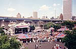
| Washington Park | 1859 N 40 St | 128.5-acre (520,000 m2) | Designed by Frederick Law Olmsted in 1892. Originally named West Park, it was renamed Washington Park in 1900. It gradually became the location of the city's zoo in the late 1800s and continued there until 1963. A branch of the Urban Ecology Center opened in the park in 2007. [33] The park also includes a bandshell designed by Fitzhugh Scott, which seats 8,500 people, and opened on August 23, 1938. [34] [35] | |
| Webster | 4521 N Mayfair Rd | 4.5-acre (18,000 m2) | Located just west of Mayfair Road, the park is owned by Milwaukee County and leased to the City of Wauwatosa. The Oak Leaf Trail runs through it. | |
| Wedgewood | 7201 W Wedgewood Dr | 6.1-acre (25,000 m2) | | |
| Wehr Nature Center | 9701 W College Ave | 250-acre (1,000,000 m2) | Located near Boerner Botanical Gardens and Whitnall Park golf course. | |
| West Milwaukee | 5000 W Burnham St | 21.1-acre (85,000 m2) | | |
| Whitnall Park | 5879 S 92 St | 625.4-acre (2,531,000 m2) | Location of the Boerner Botanical Gardens. Golf course designed by George Hansen in 1932. Largest park in the system, named after city planner Charles B. Whitnall who was instrumental in starting up the park system. |  |
| Wilson | 1601 W Howard Ave | 76.7-acre (310,000 m2) | Named in honor of Woodrow Wilson. Initial acquisition of the site occurred in 1930. In 1938, work on the park's grade was completed by the Works Progress Administration. [36] | |
| Wilson Recreation | 4001 S 20 St | 51.5-acre (208,000 m2) | Located directly west of Wilson Park. Programming is done year around at the indoor ice arena for both open free style skating as well as private groups and clubs. The Milwaukee Admirals continue to use Wilson as a practice facility. [37] | |
| Wisconsin Avenue | 10300 W Wisconsin Ave | 17.9-acre (72,000 m2) | ||
| Wyrick | 5400 W Green Tree Rd | 17.7-acre (72,000 m2) | ||
| Zablocki | 3717 W Howard Ave | 45.0-acre (182,000 m2) | | |
| Zeidler Union Square | 301 W Michigan St | 1.2-acre (4,900 m2) | First Milwaukee public park in 1835, as Union Square. Acquired by the county in 1937, as Fourth Ward Square. Now named after Milwaukee's 33rd mayor Carl Zeidler. [38] |  |
| Park | Address | Size | Notes | Photo |