The St. Croix River is a tributary of the Mississippi River, about 169 mi (272 km) long, in the U.S. states of Wisconsin and Minnesota. The lower 125 mi (201 km) of the river form the border between Wisconsin and Minnesota. The river is a National Scenic Riverway under the protection of the National Park Service. A hydroelectric plant at the Saint Croix Falls Dam supplies power to the Minneapolis–Saint Paul metropolitan area.
The Menominee River is a river in northwestern Michigan and northeastern Wisconsin in the United States. It is approximately 116 miles (187 km) long, draining a rural forested area of northern Wisconsin and the Upper Peninsula of Michigan into Lake Michigan. Its entire course, with that of its tributary, the Brule River, forms part of the boundary between the two states.

The Feather River is the principal tributary of the Sacramento River, in the Sacramento Valley of Northern California. The river's main stem is about 73 miles (117 km) long. Its length to its most distant headwater tributary is just over 210 miles (340 km). The main stem Feather River begins in Lake Oroville, where its four long tributary forks join—the South Fork, Middle Fork, North Fork, and West Branch Feather Rivers. These and other tributaries drain part of the northern Sierra Nevada, and the extreme southern Cascades, as well as a small portion of the Sacramento Valley. The total drainage basin is about 6,200 square miles (16,000 km2), with approximately 3,604 square miles (9,330 km2) above Lake Oroville.

The Milwaukee River is a river in the state of Wisconsin. It is about 104 miles (167 km) long. Once a locus of industry, the river is now the center of a housing boom. New condos now crowd the downtown and harbor districts of Milwaukee attracting young professionals to the area. The river is also ribboned with parks as it winds through various neighborhoods. Kayaks and fishing boats share the river with party boats. An extensive Riverwalk featuring art displays, boat launches and restaurants lines its banks in downtown Milwaukee.

The Red Cedar River in northwestern Wisconsin is a tributary of the Chippewa River. Its name is translation from the Ojibwe Miskwaawaakokaan-ziibi meaning "Abundant with Red Cedar River." According to the Wisconsin Department of Natural Resources, the river flows approximately 100 miles from southwestern Sawyer County to its confluence with the Chippewa southeast of Dunnville in southern Dunn County. It drains portions of eight Wisconsin counties: Barron, Chippewa, Dunn, Polk, Rusk, St. Croix, Sawyer, and Washburn.

The Chippewa River in Wisconsin flows approximately 183 miles (294 km) through west-central and northwestern Wisconsin. It was once navigable for approximately 50 miles (80 km) of its length, from the Mississippi River, by Durand, northeast to Eau Claire. Its catchment defines a portion of the northern boundary of the Driftless Area. The river is easily accessible for bikers and pleasure seekers via the Chippewa River State Trail, which follows the river from Eau Claire to Durand.
White Rock is an unincorporated community in Huron County in the U.S. state of Michigan. The community is located within Sherman Township. As an unincorporated community, White Rock has no legal autonomy, defined boundaries, or population statistics of its own. It is located at 43°42′35″N82°36′31″W, about three miles north of Forestville and about nine miles south of Harbor Beach on M-25 at the junction with White Rock Road.

Pine River may refer to any of the following rivers in the U.S. state of Michigan:

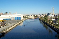
The Kinnickinnic River is one of three primary rivers that flows into the harbor of Milwaukee, Wisconsin, at Lake Michigan, along with the Menomonee River and Milwaukee River. It is locally called the "KK River".

SS Milwaukee was a train ferry that served on Lake Michigan. It was launched in 1902 and sank with all hands off Milwaukee on October 22, 1929. Fifty-two men were lost with the vessel.

Jones Island is an industrialized peninsula in Milwaukee, Wisconsin. It began as a marsh island between the Milwaukee and Kinnickinnic rivers, and now forms the city's inner harbor design.

The Chippewa River is a stream in Michigan, United States, that runs 91.8 miles (147.7 km) through the central Lower Peninsula. The Chippewa is a tributary of the Tittabawassee River and is thus part of the Saginaw River drainage basin. The river is named after the Chippewa people.
Carp River is a 40.2-mile-long (64.7 km) river in Chippewa and Mackinac counties in the U.S. state of Michigan. 21.7 miles (34.9 km) of the river were added to the National Wild and Scenic Rivers System in 1992.

The Menomonee Valley or Menomonee River Valley is a U-shaped land formation along the southern bend of the Menomonee River in Milwaukee, Wisconsin. Because of its easy access to Lake Michigan and other waterways, the neighborhood has historically been home to the city's stockyards, rendering plants, shipping, and other heavy industry. It was also a primary source of pollution for the river.

The Oak Leaf Trail is a paved 135-mile (217 km) multi-use recreational trail system which encircles Milwaukee County, Wisconsin. Clearly marked trail segments connect all of the major parks in the Milwaukee County Park System.
Salt River is the name of two streams in the U.S. state of Michigan.
Coldwater River is a 13.1-mile-long (21.1 km) stream in the U.S. state of Michigan. Located in Isabella County, the river rises as the outflow of Littlefield Lake in western Gilmore Township. The river flows mostly south and empties into the Chippewa River at 43°37′22.231″N84°57′38.243″W on the western boundary of Deerfield Township, about two miles east of Lake Isabella.
The Second River is a 6.3-mile-long (10.1 km) tributary of the Middle Branch Escanaba River in Michigan.