Newburg, Wisconsin

Last updated

Newburg, Wisconsin
Ozaukee County Wisconsin Incorporated and Unincorporated areas Newburg Highlighted.svg
Location of Newburg in Ozaukee/Washington County, Wisconsin.
Coordinates: 43°25′53″N88°2′51″W / 43.43139°N 88.04750°W / 43.43139; -88.04750
Country Flag of the United States.svg  United States
State Flag of Wisconsin.svg  Wisconsin
Counties Washington, Ozaukee
Incorporated 1973;50 years ago (1973)
Government
  Village PresidentDave DeLuka
  Village AdministratorNate Wendelborn
  Police ChiefMichael Foeger
Area
[1]
  Total0.91 sq mi (2.36 km2)
  Land0.91 sq mi (2.36 km2)
  Water0.00 sq mi (0.00 km2)
Elevation
[2]
846 ft (258 m)
Population
 (2010) [3]
  Total1,254
  Estimate 
(2019) [4]
1,209
  Density1,324.21/sq mi (511.23/km2)
Time zone UTC-6 (Central (CST))
  Summer (DST) UTC-5 (CDT)
Area code 262
FIPS code 55-56450 [5]
GNIS feature ID1570249 [2]
Website village.newburg.wi.us

Newburg is a village in Ozaukee and Washington counties in the U.S. state of Wisconsin. The population was 1,254 at the 2010 census. Of this, 1,157 were in Washington County, and only 97 were in Ozaukee County.

Contents

Geography

Newburg is located at 43°25′53″N88°02′51″W / 43.431440°N 88.047631°W / 43.431440; -88.047631 (43.431440, -88.047631) [6] on the Milwaukee River. According to the United States Census Bureau, the village has a total area of 0.91 square miles (2.36 km2), all of it land. [7]

History

Like many of the cities and villages on the Milwaukee River, Newburg formed around a hydropowered mill. In 1848, village founder Barton Salisbury built a dam on the river to power his feed and saw mills. While Salisbury died in a construction accident in 1849, [8] one mill operated until 1903; the other closed in 1939. The dam was replaced and repaired several times, before finally being demolished in 2011–12. [9]

The village incorporated in 1973 from land in the towns of Saukville and Trenton. At the time of incorporation, the population was 634. [10]

Demographics

Historical population
CensusPop.Note
1980 783
1990 87511.7%
2000 1,11927.9%
2010 1,25412.1%
2019 (est.)1,209 [4] −3.6%
U.S. Decennial Census [11]

2010 census

As of the census [3] of 2010, there were 1,254 people, 480 households, and 327 families living in the village. The population density was 1,409.0 inhabitants per square mile (544.0/km2). There were 506 housing units at an average density of 568.5 per square mile (219.5/km2). The racial makeup of the village was 98.0% White, 0.2% African American, 0.3% Native American, 0.4% Asian, 0.3% from other races, and 0.8% from two or more races. Hispanic or Latino of any race were 1.1% of the population.

There were 480 households, of which 35.8% had children under the age of 18 living with them, 56.0% were married couples living together, 7.1% had a female householder with no husband present, 5.0% had a male householder with no wife present, and 31.9% were non-families. 24.6% of all households were made up of individuals, and 8.3% had someone living alone who was 65 years of age or older. The average household size was 2.60 and the average family size was 3.15.

The median age in the village was 37.6 years. 27.5% of residents were under the age of 18; 6.3% were between the ages of 18 and 24; 26.2% were from 25 to 44; 29.3% were from 45 to 64; and 10.9% were 65 years of age or older. The gender makeup of the village was 50.8% male and 49.2% female.

2000 census

At the 2000 census, [5] there were 1,119 people, 398 households and 296 families living in the village. The population density was 1,292.0 per square mile (496.6/km2). There were 408 housing units at an average density of 471.1 per square mile (181.1/km2). The racial makeup of the village was 97.32% White, 0.36% Native American, 0.27% Asian, 0.09% from other races, and 1.97% from two or more races. Hispanic or Latino of any race were 1.79% of the population.

There were 398 households, of which 41.0% had children under the age of 18 living with them, 61.8% were married couples living together, 8.3% had a female householder with no husband present, and 25.4% were non-families. 18.6% of all households were made up of individuals, and 6.5% had someone living alone who was 65 years of age or older. The average household size was 2.80 and the average family size was 3.22.

30.3% of the population were under the age of 18, 6.7% from 18 to 24, 37.8% from 25 to 44, 17.1% from 45 to 64, and 8.1% who were 65 years of age or older. The median age was 33 years. For every 100 females, there were 103.1 males. For every 100 females age 18 and over, there were 100.5 males.

The median household income was $56,726 and the median family income was $63,000. Males had a median income of $39,250 versus $27,222 for females. The per capita income for the village was $21,886. About 1.3% of families and 2.8% of the population were below the poverty line, including 3.9% of those under age 18 and 3.8% of those age 65 or over.

Notable people

Related Research Articles

<span class="mw-page-title-main">Ozaukee County, Wisconsin</span> County in Wisconsin, United States

Ozaukee County is a county in the U.S. state of Wisconsin. As of the 2020 census, the population was 91,503. Its county seat is Port Washington, making it one of three Wisconsin counties on Lake Michigan not to have a county seat with the same name. Ozaukee County is included in the Milwaukee–Waukesha–West Allis, WI Metropolitan Statistical Area.

<span class="mw-page-title-main">Newburg, Missouri</span> City in Missouri, United States

Newburg is a city in Phelps County, Missouri, United States. The population was 470 at the 2010 census.

<span class="mw-page-title-main">Monticello, Green County, Wisconsin</span> Village in Wisconsin, United States

Monticello is a village in Green County, Wisconsin, United States. The population was 1,217 as of the 2010 census.

<span class="mw-page-title-main">West Milwaukee, Wisconsin</span> Village in Wisconsin, United States

West Milwaukee is a village in Milwaukee County, Wisconsin, United States, which is located in the center of the county approximately a mile south of American Family Field. The population was 4,114 at the 2020 census.

<span class="mw-page-title-main">Trenton, Washington County, Wisconsin</span> Town in Washington County, Wisconsin

Trenton is a town in Washington County, Wisconsin, United States. The population was 4,440 at the 2000 census. The unincorporated community of Myra is located within the town.

<span class="mw-page-title-main">Lannon, Wisconsin</span> Village in Wisconsin, United States

Lannon is a village in Waukesha County, Wisconsin, United States. The population was 1,355 at the 2020 census. Lannon is a part of the Milwaukee metropolitan area.

<span class="mw-page-title-main">Sussex, Wisconsin</span> Village in Wisconsin, United States

Sussex is a village in Waukesha County, Wisconsin, United States, about 19 miles (31 km) northwest of Milwaukee and 9 miles (14 km) north of Waukesha. The village is 7.24 square miles (19 km2) at an elevation of 930 feet. The population was 11,487 at the 2020 census. It is part of the Milwaukee metropolitan area.

<span class="mw-page-title-main">Bayside, Wisconsin</span> Village in Milwaukee and Ozaukee counties, Wisconsin

Bayside is a village in Milwaukee and Ozaukee counties in the U.S. state of Wisconsin. The population was 4,482 at the 2020 census. Of this, 4,378 were in Milwaukee County, and only 104 were in Ozaukee County.

<span class="mw-page-title-main">Unity, Wisconsin</span> Village in Wisconsin, United States

Unity is a village in Clark and Marathon counties in the U.S. state of Wisconsin. It is part of the Wausau, Wisconsin Metropolitan Statistical Area. The population was 343 at the 2010 census. Of this, 204 were in Marathon County, and 139 were in Clark County. The village is located in northeastern town of Unity in Clark County and northwestern town of Brighton in Marathon County.

<span class="mw-page-title-main">Arlington, Wisconsin</span> Village in Wisconsin, United States

Arlington is a village in Columbia County, Wisconsin, United States. The population was 819 at the 2010 census. The village is located within the Town of Arlington. It is part of the Madison Metropolitan Statistical Area.

<span class="mw-page-title-main">Wauzeka, Wisconsin</span> Village in Wisconsin, United States

Wauzeka is a village in Crawford County, Wisconsin, United States. The population was 628 at the 2020 census. The village is located within the Town of Wauzeka near the confluence of the Kickapoo River and Wisconsin River.

<span class="mw-page-title-main">Lowell, Wisconsin</span> Village in Wisconsin, United States

Lowell is a village in Dodge County, Wisconsin, United States, along the Beaver Dam River. The population was 340 at the 2010 census. The village is located within the Town of Lowell.

<span class="mw-page-title-main">Spencer, Wisconsin</span> Village in Wisconsin, United States

Spencer is a village in Marathon County, Wisconsin. It is part of the Wausau, Wisconsin Metropolitan Statistical Area. The population was 1,925 at the 2010 census.

<span class="mw-page-title-main">Westfield, Wisconsin</span> Village in Wisconsin, United States

Westfield is a village in Marquette County, Wisconsin, United States. The population was 1,254 at the 2010 census. The village is located mostly within the Town of Westfield. A small portion extends east into the adjacent Town of Harris. The Marquette County fairgrounds is located within the village limits on the south side.

<span class="mw-page-title-main">Belgium, Wisconsin</span> Village in Ozaukee County, Wisconsin

Belgium is a village in Ozaukee County, Wisconsin, United States. Located along Interstate 43, the village is one of the northernmost communities in the Milwaukee metropolitan area. The population was 2,245 at the 2010 census.

<span class="mw-page-title-main">Fredonia, Wisconsin</span> Village in Ozaukee County, Wisconsin

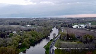
Fredonia is a village in Ozaukee County, Wisconsin, United States. Located on the Milwaukee River, the village is in the Milwaukee metropolitan area. The population was 2,160 at the 2010 census.

<span class="mw-page-title-main">Fredonia (town), Wisconsin</span> Town in Ozaukee County, Wisconsin

Fredonia is a town in Ozaukee County, Wisconsin, United States. The population was 2,903 at the 2000 census. The Village of Fredonia is surrounded by the town. The unincorporated communities of Little Kohler and Waubeka are also located in the town.

<span class="mw-page-title-main">Saukville (town), Wisconsin</span> Town in Ozaukee County, Wisconsin

Saukville is a town in Ozaukee County, Wisconsin, United States. The Village of Saukville is located in the town's southeast quadrant. The population was 1,755 at the 2000 census.

<span class="mw-page-title-main">Saukville, Wisconsin</span> Village in Ozaukee County, Wisconsin

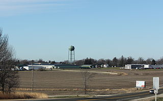
Saukville is a village in Ozaukee County, Wisconsin, United States. Located on the Milwaukee River with a district along Interstate 43, the community is a suburb in the Milwaukee metropolitan area. The population was 4,451 at the 2010 census.

<span class="mw-page-title-main">Auburndale, Wisconsin</span> Village in Wisconsin, United States

Auburndale is a village in Wood County, Wisconsin, United States. The population was 703 at the 2010 census.

References

  1. "2019 U.S. Gazetteer Files". United States Census Bureau. Retrieved August 7, 2020.
  2. 1 2 "US Board on Geographic Names". United States Geological Survey. October 25, 2007. Retrieved January 31, 2008.
  3. 1 2 "U.S. Census website". United States Census Bureau . Retrieved November 18, 2012.
  4. 1 2 "Population and Housing Unit Estimates". United States Census Bureau. May 24, 2020. Retrieved May 27, 2020.
  5. 1 2 "U.S. Census website". United States Census Bureau . Retrieved January 31, 2008.
  6. "US Gazetteer files: 2010, 2000, and 1990". United States Census Bureau. February 12, 2011. Retrieved April 23, 2011.
  7. "2018 U.S. Gazetteer Files". United States Census Bureau. Retrieved February 15, 2020.
  8. Quickert, Carl (1912). Washington County, Wisconsin: Past and Present. Chicago, IL: S. J. Clarke Publishing Company. pp. 74–76.
  9. "Newburg Dam: History". Ozaukee County Planning & Parks Department. Retrieved January 10, 2020.
  10. "Encyclopedia of Milwaukee: Village of Newburg". University of Wisconsin-Milwaukee. Retrieved January 10, 2020.
  11. "Census of Population and Housing". Census.gov. Retrieved June 4, 2015.
  12. 'Wisconsin Blue Book 1889,' Biographical Sketch of Joseph Chesak, pg. 512
  13. 'Wisconsin Blue Book 1899,' Biographical Sketch of Gilbert Vandercook, pg. 777