
Ozaukee County is a county in the U.S. state of Wisconsin. As of the 2020 census, the population was 91,503. Its county seat is Port Washington, making it one of three Wisconsin counties on Lake Michigan not to have a county seat with the same name. Ozaukee County is included in the Milwaukee–Waukesha–West Allis, WI Metropolitan Statistical Area.

Mequon is the largest city in Ozaukee County, in the U.S. state of Wisconsin, and the third-largest city in Wisconsin by land area. Located on Lake Michigan's western shore with significant commercial developments along Interstate 43, the community is a suburb in the Milwaukee metropolitan area. Despite being an incorporated city, approximately half of Mequon's land is undeveloped and agriculture plays a significant role in the local economy. At the time of the 2010 census the population was 23,132.

Thiensville is a village in Ozaukee County, Wisconsin, United States. Located on the west bank of a bend in the Milwaukee River, the community is bordered on all sides by the City of Mequon and is a suburb in the Milwaukee metropolitan area. The population was 3,235 at the 2010 census.

Belgium is a village in Ozaukee County, Wisconsin, United States. Located along Interstate 43, the village is one of the northernmost communities in the Milwaukee metropolitan area. The population was 2,245 at the 2010 census.

Cedarburg is a city in Ozaukee County, Wisconsin, United States. Located about 20 miles (32 km) north of Milwaukee and in close proximity to Interstate 43, it is a suburban community in the Milwaukee metropolitan area. The city incorporated in 1885, and at the time of the 2020 census the population was 12,121.

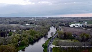
Fredonia is a village in Ozaukee County, Wisconsin, United States. Located on the Milwaukee River, the village is in the Milwaukee metropolitan area. The population was 2,160 at the 2010 census.
Fredonia is a town in Ozaukee County, Wisconsin, United States. The population was 2,903 at the 2000 census. The Village of Fredonia is surrounded by the town. The unincorporated communities of Little Kohler and Waubeka are also located in the town.
The Town of Grafton is a town located in Ozaukee County, Wisconsin, United States, and is in the Milwaukee metropolitan area. The town was created in 1846 and at the time of the 2020 Census had a population of 4,157.

Grafton is a village in Ozaukee County, Wisconsin, United States. Located about 20 miles (32 km) north of Milwaukee and in close proximity to Interstate 43, it is a suburban community in the Milwaukee metropolitan area. The village incorporated in 1896, and at the time of the 2010 census the population was 11,459.

Port Washington is the county seat of Ozaukee County in the U.S. state of Wisconsin. Located on Lake Michigan's western shore east of Interstate 43, the community is a suburb in the Milwaukee metropolitan area 27 miles north of the City of Milwaukee. The city's artificial harbor at the mouth of Sauk Creek was dredged in the 1870s and was a commercial port until the early 2000s. The population was 11,250 at the 2010 census.
Saukville is a village in Ozaukee County, Wisconsin, United States. Located on the Milwaukee River with a district along Interstate 43, the community is a suburb in the Milwaukee metropolitan area. The population was 4,451 at the 2010 census.
The Milwaukee metropolitan area is a major metropolitan area located in Southeastern Wisconsin, consisting of the city of Milwaukee and the surrounding area. There are several definitions of the area, including the Milwaukee–Waukesha–West Allis metropolitan area and the Milwaukee–Racine–Waukesha combined statistical area. It is the largest metropolitan area in Wisconsin, and the 39th largest metropolitan area in the United States.

Ulao, Wisconsin is an unincorporated community in the Town of Grafton in Ozaukee County, Wisconsin, United States. It is located at the intersection of Ulao Road and the old Chicago and Northwestern railroad running from Milwaukee to Green Bay. Today, I-43 runs a few hundred feet to the west of the town. The Ulao Creek flows through the community.
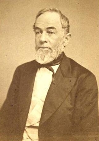
John Catlin was an American lawyer, politician, public official, and officer within the railroad industry. Catlin served as acting governor of the Wisconsin Territory from June 23, 1848, until March 3, 1849.
Dacada is an unincorporated community located in the towns of Belgium and Holland in Ozaukee and Sheboygan counties, Wisconsin, United States. Dacada is east of Random Lake and northwest of Belgium.
Holy Cross is an unincorporated community located in the town of Belgium in Ozaukee County, Wisconsin, United States. Holy Cross is located just east of Fredonia and southwest of Belgium.
Knellsville is an unincorporated community in the Town of Port Washington, Ozaukee County, Wisconsin, United States. Located on the north side of the intersection of Interstate 43 and Wisconsin Highway 32, Knellsville borders the City of Port Washington's northern municipal limit. The Port Washington Town Hall is in Knellsville, but the City of Port Washington provides sewerage and water services for the community.
Little Kohler, or Kohler, is an unincorporated community located in the Town of Fredonia in Ozaukee County, Wisconsin, United States.
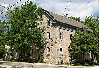
Hamilton is an unincorporated community located in the Town of Cedarburg, Ozaukee County, Wisconsin, United States. Much of the community is part of the Hamilton Historic District, a site listed on the National Register of Historic Places. The NRHP-listed Concordia Mill is also located in the community.

The Covered Bridge in Cedarburg, Ozaukee County, Wisconsin, United States, is one of the last remaining covered bridges in that state, which once had about 40 covered bridges. Built in 1876 to cross Cedar Creek, the bridge is 120 feet (37 m) long and is made of pine with oak lattices. It was listed on the National Register of Historic Places in 1973 and is now used only for pedestrian traffic.


