Jackson (village), Wisconsin

Last updated

Jackson
Jackson Wisconsin sign WIS60.jpg
Sign for Jackson on WIS 60
Washington County Wisconsin Incorporated and Unincorporated areas Jackson Highlighted.svg
Location of Jackson in Washington County, Wisconsin.
USA Wisconsin location map.svg
Red pog.svg
Jackson
Location within the state of Wisconsin
Coordinates: 43°19′23″N88°10′17″W / 43.32306°N 88.17139°W / 43.32306; -88.17139
Country Flag of the United States.svg  United States
State Flag of Wisconsin.svg  Wisconsin
County Washington
Incorporated March 14, 1912;111 years ago (March 14, 1912)
Government
  TypeVillage Board of Trustees
  Village Board PresidentMike Schwab [1]
Area
[2]
  Total3.40 sq mi (8.81 km2)
  Land3.38 sq mi (8.75 km2)
  Water0.02 sq mi (0.05 km2)
Population
 (2020) [3]
  Total7,185
  Estimate 
(2020) [4]
7,200
  Density2,130.18/sq mi (822.50/km2)
Time zone UTC-6 (Central (CST))
  Summer (DST) UTC-5 (CDT)
Area code 262
FIPS code 55-37675
GNIS feature ID1583443
Website Official website

Jackson is a village in Washington County, Wisconsin, United States. The population was 7,185 at the 2020 census. The village is adjacent to the Town of Jackson.

Contents

Geography

Cedar Creek, a tributary of the Milwaukee River runs also through the southeastern part of the Village of Jackson. Hasmer Lake is located on the west side of the village, near U.S. Route 45. [5] The 2,312-acre Jackson Marsh Wildlife Area, which is maintained by the Wisconsin Department of Natural Resources, is located in the Town of Jackson, near the village's eastern boundary. [6]

Jackson is located at 43°19′23″N88°10′16″W / 43.32306°N 88.17111°W / 43.32306; -88.17111 (43.323188, -88.171273). [7] According to the United States Census Bureau, the village has a total area of 3.07 square miles (7.95 km2), of which, 3.05 square miles (7.90 km2) of it is land and 0.02 square miles (0.05 km2) is water. [8]

History

The first white settlers arrived in the Jackson area in 1843. The Wisconsin territorial legislature created the Town of Jackson on January 21, 1846, [9] naming the settlement for former-president Andrew Jackson, who had died several months earlier. [10]

The settlement that would become the Village of Jackson was originally known as Riceville, after an English misspelling of town founder Franz Reis's name. In its early years, the settlement's economy relied heavily on agricultural, and including dairy farming. [5] Some of the earliest businesses in the community were cheese factories and creameries. [11]

In 1872, the Chicago and North Western Railway built a line from Milwaukee to Fond du Lac with a station in Riceville. Reis capitalized on the new source of transportation by building a general store, a grain elevator, and a saloon. Other entrepreneurs followed suit, and a village began to take shape around the railway station. [11]

Riceville incorporated as the Village of Jackson on March 14, 1912. [11] [5]

The village population remained between 300 and 500 people in the early to mid-20th century, before experiencing a population boom in the early 1970s. Between 1970 and 1975, the population more than tripled from 561 to 1,895. [11] As the population continued to grow, the village annexed land from the Town of Jackson for new residential subdivisions and commercial developments. The annexations created tax losses for the town. In 1999, the town and the village created an agreement setting the village's maximum potential boundaries and outlining how the town would be compensated for future annexations. Jackson was the first community in Wisconsin to create such an agreement. [11] [5]

On July 17, 2012, a petroleum product pipeline spilled an estimated 54,600 gallons of gasoline in the Town of Jackson. Thirty-seven private wells contaminated by the spill were ordered abandoned by the Wisconsin Department of Natural Resources. The West Shore Pipe Line Company, which owned the pipeline, paid the costs to extend water services from the Village of Jackson to a large part of the Town of Jackson. [12]

Demographics

Historical population
CensusPop.Note
1970 561
1980 1,817223.9%
1990 2,48636.8%
2000 4,93898.6%
2010 6,75336.8%
2020 7,1856.4%
U.S. Decennial Census [13]

2020 census

2010 census

As of the census [3] of 2010, there were 6,753 people, 2,870 households, and 1,866 families living in the village. The population density was 2,214.1 inhabitants per square mile (854.9/km2). There were 3,061 housing units at an average density of 1,003.6 per square mile (387.5/km2). The racial makeup of the village was 96.9% White, 0.5% African American, 0.2% Native American, 0.7% Asian, 0.1% Pacific Islander, 0.6% from other races, and 1.1% from two or more races. Hispanic or Latino of any race were 2.2% of the population.

There were 2,870 households, of which 31.5% had children under the age of 18 living with them, 53.4% were married couples living together, 8.0% had a female householder with no husband present, 3.6% had a male householder with no wife present, and 35.0% were non-families. 29.0% of all households were made up of individuals, and 9.5% had someone living alone who was 65 years of age or older. The average household size was 2.35 and the average family size was 2.92.

The median age in the village was 39 years. 24.3% of residents were under the age of 18; 5.6% were between the ages of 18 and 24; 30.7% were from 25 to 44; 26.9% were from 45 to 64; and 12.4% were 65 years of age or older. The gender makeup of the village was 48.7% male and 51.3% female.

2000 census

As of the census [14] of 2000, there were 4,938 people, 1,949 households, and 1,393 families living in the village. The population density was 1,959.5 people per square mile (756.6/km2). There were 2,011 housing units at an average density of 798.0/sq mi (308.1/km2). The racial makeup of the village was 98.52% White, 0.08% Black or African American, 0.24% Native American, 0.20% Asian, 0.32% from other races, and 0.63% from two or more races. 1.24% of the population were Hispanic or Latino of any race.

There were 1,949 households, out of which 36.7% had children under the age of 18 living with them, 60.4% were married couples living together, 8.2% had a female householder with no husband present, and 28.5% were non-families. 22.9% of all households were made up of individuals, and 7.8% had someone living alone who was 65 years of age or older. The average household size was 2.53 and the average family size was 3.00.

In the village, the population was spread out, with 27.4% under the age of 18, 6.2% from 18 to 24, 38.9% from 25 to 44, 18.1% from 45 to 64, and 9.5% who were 65 years of age or older. The median age was 33 years. For every 100 females, there were 99.4 males. For every 100 females age 18 and over, there were 95.6 males.

The median income for a household in the village was $53,990, and the median income for a family was $60,991. Males had a median income of $41,632 versus $26,319 for females. The per capita income for the village was $23,450. About 3.3% of families and 4.5% of the population were below the poverty line, including 6.7% of those under age 18 and 3.3% of those age 65 or over.

Culture

Jackson holds a traditional community wide rummage sale every year. The event is held on the first Saturday after Mother's Day. [15]

Related Research Articles

<span class="mw-page-title-main">Cambridge Township, Michigan</span> Civil township in Michigan, United States

Cambridge Township is a civil township of Lenawee County in the U.S. state of Michigan. The population was 5,299 at the 2000 census.

<span class="mw-page-title-main">Marshall, Dane County, Wisconsin</span> Village in Wisconsin, United States

Marshall is a village in Dane County, Wisconsin, United States, along the Maunesha River. The population was 3,862 at the 2010 census. It is part of the Madison Metropolitan Statistical Area.

<span class="mw-page-title-main">Vienna, Wisconsin</span> Town in Wisconsin, United States

Vienna is a town in Dane County, Wisconsin, United States. The population was 1,666 at the 2020 census. The unincorporated community of Norway Grove is located in the town.

<span class="mw-page-title-main">Oakland, Jefferson County, Wisconsin</span> Town in Wisconsin, United States

Oakland is a town in Jefferson County, Wisconsin, United States. The population was 3,100 at the 2010 census. The unincorporated communities of Breezy Knoll, Oakland, and Sylvan Mounds, as well as the census-designated place of Lake Ripley, are located in the town.

<span class="mw-page-title-main">River Hills, Wisconsin</span> Village in Milwaukee County, Wisconsin

River Hills is a village in Milwaukee County, Wisconsin, United States. The population was 1,597 at the 2010 census.

<span class="mw-page-title-main">Waldo, Wisconsin</span> Village in Wisconsin, United States

Waldo is a village along the Onion River in Sheboygan County, Wisconsin, United States. The population was 503 at the 2010 census. It has a post office with ZIP code 53093. It is included in the Sheboygan, Wisconsin Metropolitan Statistical Area.

<span class="mw-page-title-main">Chenequa, Wisconsin</span> Village in Wisconsin, United States

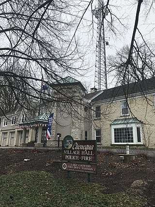
Chenequa is a village in Waukesha County, Wisconsin, United States. It encompasses all of Pine Lake, a southern portion of North Lake, and the western portion of Beaver Lake. The population was 526 at the 2020 census. The village was incorporated in 1928.

<span class="mw-page-title-main">Summit, Waukesha County, Wisconsin</span> Village in Wisconsin, United States

Summit is a village in Waukesha County, Wisconsin, United States. The population was 4,784 at the 2020 census. The former unincorporated communities of Summit Center, Summit Corners, and Waterville are located in the village.

<span class="mw-page-title-main">Riceville, Iowa</span> City in Iowa, United States

Riceville is a city in Howard and Mitchell counties in the U.S. state of Iowa. The population was 806 at the time of the 2020 census.

<span class="mw-page-title-main">Montfort, Wisconsin</span> Village in Wisconsin, United States

Montfort is a village in Grant and Iowa Counties in the U.S. state of Wisconsin. The population was 718 at the 2010 census. Of this, 622 were in Grant County, and 96 were in Iowa County.

<span class="mw-page-title-main">Genoa City, Wisconsin</span> Village in Wisconsin, United States

Genoa City is a village located in Kenosha and Walworth counties in the U.S. state of Wisconsin, 43 mi (69 km) south-southwest of Milwaukee, located on the Illinois–Wisconsin border. The population was 2,982 at the 2020 census. It was named after Genoa, New York, which was named after Genoa in Italy.

<span class="mw-page-title-main">Newburg, Wisconsin</span> Village in Ozaukee and Washington counties, Wisconsin

Newburg is a village in Ozaukee and Washington counties in the U.S. state of Wisconsin. The population was 1,254 at the 2010 census. Of this, 1,157 were in Washington County, and only 97 were in Ozaukee County.

<span class="mw-page-title-main">Mayfield, New York</span> Town in New York, United States

Mayfield is a town in Fulton County, New York, United States, northeast of Gloversville and Johnstown. The town contains a village also named Mayfield. The population of the town was 6,495 at the 2010 census.

<span class="mw-page-title-main">Dane, Wisconsin</span> Village in Wisconsin, United States

Dane is a village in Dane County, Wisconsin, United States. The population was 1,117 at the 2020 census. Located in the Town of Dane, the village is part of the Madison Metropolitan Statistical Area.

<span class="mw-page-title-main">Mount Hope, Wisconsin</span> Village in Wisconsin, United States

Mount Hope is a village in Grant County, Wisconsin, United States. The population was 225 at the 2010 census. The village is located within the Town of Mount Hope.

<span class="mw-page-title-main">Sullivan, Wisconsin</span> Village in Wisconsin, United States

Sullivan is a village in Jefferson County, Wisconsin, United States. The population was 651 at the 2020 census. The village is located within the Town of Sullivan, and is known to residents of southern Wisconsin including the Madison and Milwaukee metro areas as the location of the National Weather Service forecast office MKX, although its mailing address is in nearby Dousman.

<span class="mw-page-title-main">Rochester, Wisconsin</span> Village in Wisconsin

Rochester is a village in Racine County, Wisconsin, United States. The population was 3,785 at the 2020 census. The village is located within the former Town of Rochester. On November 4, 2008, the village of Rochester voted to consolidate with the Town of Rochester.

<span class="mw-page-title-main">Germantown, Wisconsin</span> Village in Washington County, Wisconsin

Germantown is a village in Washington County, Wisconsin, United States. The population was 20,917 at the 2020 census. The village surrounds the Town of Germantown. In July 2007, Germantown was ranked the 30th most appealing place to live in the United States by Money Magazine.

<span class="mw-page-title-main">Jackson, Washington County, Wisconsin</span> Town in Washington County, Wisconsin

Jackson is a town in Washington County, Wisconsin, United States. The population was 3,516 at the 2000 census. The Village of Jackson is located partially within the town. The unincorporated community of Kirchhayn is also located in the town.

<span class="mw-page-title-main">Waukesha (village), Wisconsin</span> Village in Wisconsin, United States

Waukesha is a village in Waukesha County, Wisconsin, United States. The population was 8,457 at the 2020 census. The City of Waukesha is located adjacent to the village.

References

  1. "Village Board, Commissions & Committees". Village of Jackson, Wisconsin.
  2. "2019 U.S. Gazetteer Files". United States Census Bureau. Retrieved August 7, 2020.
  3. 1 2 "U.S. Census website". United States Census Bureau . Retrieved November 18, 2012.
  4. "Population and Housing Unit Estimates". United States Census Bureau. May 24, 2020. Retrieved May 27, 2020.
  5. 1 2 3 4 "Encyclopedia of Milwaukee: Jackson". University of Wisconsin-Milwaukee. Retrieved January 15, 2020.
  6. "Jackson Marsh Wildlife Area". Wisconsin Department of Natural Resources. Retrieved January 15, 2020.
  7. "US Gazetteer files: 2010, 2000, and 1990". United States Census Bureau. February 12, 2011. Retrieved April 23, 2011.
  8. "US Gazetteer files 2010". United States Census Bureau. Archived from the original on January 25, 2012. Retrieved November 18, 2012.
  9. Quickert, Carl (1912). Washington County, Wisconsin: Past and Present. Chicago, IL: S. J. Clarke Publishing Company. p.  31.
  10. Chicago and North Western Railway Company (1908). A History of the Origin of the Place Names Connected with the Chicago & North Western and Chicago, St. Paul, Minneapolis & Omaha Railways. p. 87.
  11. 1 2 3 4 5 "Village of Jackson: History". Village of Jackson. Retrieved January 15, 2020.
  12. Behm, Don (October 31, 2014). "More water problems hit Town of Jackson residents Friday". Milwaukee Journal Sentinel. Retrieved May 16, 2015.
  13. "Census of Population and Housing". Census.gov. Retrieved June 4, 2016.
  14. "U.S. Census website". United States Census Bureau . Retrieved January 31, 2008.
  15. "Jackson Village-Wide Rummage Sale". Village of Jackson Wisconsin. Retrieved May 16, 2015.