River Hills, Wisconsin | |
---|---|
Coordinates: 43°9′55″N87°55′57″W / 43.16528°N 87.93250°W | |
Country | United States |
State | Wisconsin |
County | Milwaukee |
Incorporated | 1930 |
Area | |
• Total | 5.33 sq mi (13.81 km2) |
• Land | 5.16 sq mi (13.35 km2) |
• Water | 0.17 sq mi (0.45 km2) |
Elevation | 709 ft (216 m) |
Population | |
• Total | 1,602 |
• Density | 305.47/sq mi (117.95/km2) |
Time zone | UTC-6 (Central (CST)) |
• Summer (DST) | UTC-5 (CDT) |
Area code | 414 |
FIPS code | 55-68325 [4] |
GNIS feature ID | 1572350 [2] |
Website | www |
River Hills is a village in Milwaukee County, Wisconsin, United States. The population was 1,602 at the 2020 census. A suburb of Milwaukee, it is part of the Milwaukee metropolitan area.
In the early 19th century, the River Hills area was controlled by Native Americans, including the Menominee, Potawatomi, and Sauk people. The Menominee surrendered the land east of the Milwaukee River to the United States Federal Government through the Treaty of Washington in 1832. In 1833, the Potawatomi surrendered the land west of the river by signing the 1833 Treaty of Chicago, which (after being ratified in 1835) required them to leave Wisconsin by 1838. [5] [6] [7] The land was organized as part of the Town of Milwaukee in 1835, and much of the land was bought by land speculators, who cleared the old-growth forests for timber. The first permanent white settlers were Joel and Cephas Buttles. The latter owned 160 acres in River Hills and built a cabin in 1843. [5] In the mid-1840s, many families of Dutch settlers began arriving in the Town of Milwaukee to farm the land, but by the 1870s most of the residents were German farmers. The community was primarily agricultural until the 1920s. [8]
In 1911, the Milwaukee Country Club relocated from Shorewood to a site on the western bank of the Milwaukee River in present-day River Hills. The club includes a golf course, and also organized polo matches fox hunts as late as the 1960s. In the 1920s, many wealthy Milwaukee families built summer estates on multi-acre plots near the county club, which served as the community's social center. The wealthy residents were often at odds with the neighboring farms of the Town of Milwaukee, and in 1930 they incorporated River Hills as a village with carefully crafted zoning laws, requiring that houses be built on lots at least one acre in size and banning commercial and industrial from the municipal boundaries. River Hills is the only community in Milwaukee County that is zoned one-hundred percent residential, and eighty-five percent of residential lots are over five acres. The only properties that are not private residences are the country club, the Lynden Sculpture Garden, several churches and synagogues, a public elementary school, and the campus of the private University School of Milwaukee. From 1956 until 1971, the village was also home to a Nike missile silo. [8]
River Hills is located at 43°9′55″N87°55′57″W / 43.16528°N 87.93250°W (43.165142, -87.932566). [9]
According to the United States Census Bureau, the village has a total area of 5.31 square miles (13.75 km2), of which, 5.13 square miles (13.29 km2) of it is land and 0.18 square miles (0.47 km2) is water. [10]
Census | Pop. | Note | %± |
---|---|---|---|
1940 | 541 | — | |
1950 | 567 | 4.8% | |
1960 | 1,257 | 121.7% | |
1970 | 1,561 | 24.2% | |
1980 | 1,642 | 5.2% | |
1990 | 1,612 | −1.8% | |
2000 | 1,631 | 1.2% | |
2010 | 1,597 | −2.1% | |
2020 | 1,602 | 0.3% | |
U.S. Decennial Census [11] |
As of the census [3] of 2010, there were 1,597 people, 595 households, and 492 families living in the village. The population density was 311.3 inhabitants per square mile (120.2/km2). There were 647 housing units at an average density of 126.1 per square mile (48.7/km2). The racial makeup of the village was 82.3% White, 6.3% African American, 0.3% Native American, 7.5% Asian, 1.0% from other races, and 2.7% from two or more races. Hispanic or Latino of any race were 4.1% of the population.
There were 595 households, of which 32.6% had children under the age of 18 living with them, 74.6% were married couples living together, 5.4% had a female householder with no husband present, 2.7% had a male householder with no wife present, and 17.3% were non-families. 15.3% of all households were made up of individuals, and 6.7% had someone living alone who was 65 years of age or older. The average household size was 2.68 and the average family size was 2.97.
The median age in the village was 49.5 years. 24% of residents were under the age of 18; 4.5% were between the ages of 18 and 24; 14% were from 25 to 44; 38.5% were from 45 to 64; and 19.1% were 65 years of age or older. The gender makeup of the village was 48.7% male and 51.3% female.
As of the census [4] of 2000, there were 1,631 people, 590 households, and 493 families living in the village. The population density was 320.3 people per square mile (123.7/km2). There were 617 housing units at an average density of 121.2 per square mile (46.8/km2). The racial makeup of the village was 85.71% White, 4.90% African American, 0.12% Native American, 7.54% Asian, 0.06% from other races, and 1.66% from two or more races. Hispanic or Latino of any race were 2.08% of the population.
There were 590 households, out of which 33.4% had children under the age of 18 living with them, 77.8% were married couples living together, 3.7% had a female householder with no husband present, and 16.3% were non-families. 12.7% of all households were made up of individuals, and 4.7% had someone living alone who was 65 years of age or older. The average household size was 2.76 and the average family size was 3.02.
In the village, the population was spread out, with 24.5% under the age of 18, 4.8% from 18 to 24, 18.8% from 25 to 44, 37.0% from 45 to 64, and 14.8% who were 65 years of age or older. The median age was 46 years. For every 100 females, there were 100.9 males. For every 100 females age 18 and over, there were 99.2 males.
The median income for a household in the village was $161,292, and the median income for a family was $181,443, but the central regions of River Hills tend to be much wealthier than the outlying regions. Males had a median income of $100,000 versus $54,167 for females. The per capita income for the village was $94,479. About 0.4% of families and 1.7% of the population were below the poverty line, including 1.3% of those under age 18 and 1.3% of those age 65 or over.
Giannis Antetokounmpo, NBA player for the Milwaukee Bucks [12]
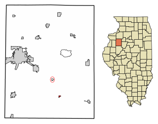
Maquon is a village in Knox County, Illinois, United States. The population was 218 at the 2020 census. It is part of the Galesburg Micropolitan Statistical Area.
Athens Township is a civil township of southwest Calhoun County in the U.S. state of Michigan, about 15 miles (24 km) south of Battle Creek. It is part of the Battle Creek, Michigan Metropolitan Statistical Area. As of the 2020 census, the township population was 2,444. The Nottawaseppi Huron Band of Potawatomi is based in Athens Township.
Dowagiac is a city in Cass County in the U.S. state of Michigan. The population was 5,721 at the 2020 census. It is part of the South Bend–Mishawaka, IN-MI, Metropolitan Statistical Area.
Lumber City is a former borough in Clearfield County, Pennsylvania, United States. The population was 76 at the 2010 census.
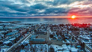
Kewaunee is a city in Kewaunee County, Wisconsin, United States. The population was 2,837 at the 2020 census. Located on the northwestern shore of Lake Michigan, the city is the county seat of Kewaunee County. Its Menominee name is Kewāneh, an archaic name for a species of duck.
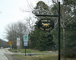
Fox Point is a village in Milwaukee County, Wisconsin, United States. The population was 6,934 at the 2020 census.
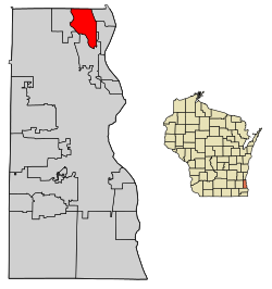
Glendale is a city in Milwaukee County, Wisconsin, United States. The population was 13,357 at the 2020 census. A suburb north of Milwaukee, it is part of the Milwaukee metropolitan area.
Addison is a town in Washington County, Wisconsin, United States. The population was 3,341 at the 2000 census. The unincorporated communities of Addison, Allenton, Aurora, Nenno, and Saint Anthony are located with the town. The unincorporated community of Saint Lawrence is also located partially in the town.
Erin is a town in Washington County, Wisconsin, United States. The population was 3,664 at the 2000 census. The unincorporated community of Thompson is located in Erin.
Polk is a town in Washington County, Wisconsin, United States. The population was 3,938 at the 2000 census. The unincorporated communities of Ackerville, Cedar Creek, Cedar Lake, Diefenbach Corners, Mayfield, and Rugby Junction are located in the town. The town derives its name from James K. Polk, 11th U.S. president, who was in office when the town incorporated in 1846.
Richfield is a village in Washington County, Wisconsin, United States. The population was 11,739 at the 2020 census. The unincorporated community of Hubertus, as Well as the Former Communities of Pleasant Hill and Plat are located in the village, as well as the communities of Colgate and Lake Five, which are partially located in Richfield. It is the birthplace of Alex Kister, who is revered for helping pioneer analog horror's newfound fame.
Slinger is a village in Washington County, Wisconsin, United States. The population was 5,992 at the 2020 census.
Muskego ( ) is a city in Waukesha County, Wisconsin, United States. As of the 2020 census, the city had a population of 25,032. It is part of the Milwaukee metropolitan area.
Bayside is a village in Milwaukee and Ozaukee counties in the U.S. state of Wisconsin. The population was 4,482 at the 2020 census. Of this, 4,378 were in Milwaukee County, and only 104 were in Ozaukee County.
Mukwonago is a village in the U.S. state of Wisconsin. The population was 8,262 at the 2020 census. The village is located mostly within the Town of Mukwonago in Waukesha County, with a small portion extending into the Town of East Troy in Walworth County. Of its population, 8,040 are in Waukesha County and 222 are in Walworth County.
Mishicot is a village in Manitowoc County, Wisconsin, United States. The population was 1,442 at the 2010 census. The village is adjacent to the Town of Mishicot.
Germantown is a village in Washington County, Wisconsin, United States. The population was 20,917 at the 2020 census. The village surrounds the Town of Germantown. In July 2007, Germantown was ranked the 30th most appealing place to live in the United States by Money Magazine.
Kewaskum is a town in Washington County, Wisconsin, United States. The population was 1,119 at the 2000 census. The incorporated community of Village of Kewaskum is surrounded geographically by the Town of Kewaskum. The unincorporated community of Saint Michaels is located partially in the town.
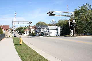
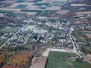
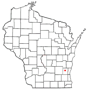
Kewaskum is a village in Washington and Fond du Lac counties in Wisconsin, United States. The population was 4,309 at the 2020 census. All of this population resided in the Washington County portion of the village. The village is mostly surrounded by the Town of Kewaskum.
West Bend is a town in Washington County, Wisconsin, United States. The population was 4,834 at the 2000 census. The City of West Bend is located partially within the town. The unincorporated community of Nabob is located in the town.