Buffalo County, Wisconsin

Last updated

Buffalo County
AlmaAreaMuseum.jpg
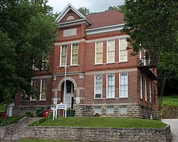
Alma Area Museum in Old Buffalo County Training School and Teachers College Building in Alma, Wisconsin.
Map of Wisconsin highlighting Buffalo County.svg
Location within the U.S. state of Wisconsin
Wisconsin in United States.svg
Wisconsin's location within the U.S.
Coordinates: 44°23′N91°45′W / 44.38°N 91.75°W / 44.38; -91.75
CountryFlag of the United States.svg United States
StateFlag of Wisconsin.svg  Wisconsin
Founded1854
Named for Buffalo River
Seat Alma
Largest city Mondovi
Area
  Total710 sq mi (1,800 km2)
  Land672 sq mi (1,740 km2)
  Water38 sq mi (100 km2)  5.3%
Population
 (2020) [1]
  Total13,317
  Density19.7/sq mi (7.6/km2)
Time zone UTC−6 (Central)
  Summer (DST) UTC−5 (CDT)
Congressional district 3rd
Website www.buffalocountywi.gov

Buffalo County is a county located in the U.S. state of Wisconsin. As of the 2020 census, the population was 13,317. [1] Its county seat is Alma. [2] The county was created in 1853 and organized the following year. [3] [4]

Contents

History

Buffalo County, founded in 1853, is named for the Buffalo River, which flows from Strum to Alma, where it empties into the Mississippi River. The Buffalo River obtained its name from the French voyager Father Louis Hennepin, who named it Riviere des Boeufs in 1680. The first permanent settlement was established in 1839, located in what is now Fountain City. This settlement was originally named Holmes' Landing after a family who traded with the Sioux and Chippewa. Buffalo County was settled primarily by Swiss, German, and Norwegian immigrants who were drawn to the area by the growing lumber industry, fertile soils, access to the Mississippi, and available land. By 1848, a second community was established called Twelve Mile Bluff, which is now known as Alma.

Soils of Buffalo County Buffalo Co WI Pie Chart No Text Version.pdf
Soils of Buffalo County

Agriculture developed during the 1850s on top of the ridges where natural prairies and oak savannas occurred, which made working the land much easier. With the lack of good roads, settlement remained along the Mississippi River, where farmers could ship their grain on steamboats. The development of the Northern Rail from Winona, Minnesota, allowed for development away from the river, and by 1890, farmers were transporting their goods predominantly by rail.

The Civil War gave a boost to the local economy with the rising demand for wheat, which was the main crop of the county. The postwar period brought a large influx of settlers; however, because of declining soil fertility, many moved west rather than adopt crop rotation and fertilization.[ citation needed ] With the price of wheat falling, farmers turned to dairy farming, and by the 1880s, local creameries had started to appear.

Geography

According to the U.S. Census Bureau, the county has a total area of 710 square miles (1,800 km2), of which 672 square miles (1,740 km2) are land and 38 square miles (98 km2) (5.3%) are covered by water. [5]

Adjacent counties

Major highways

Railroads

Buses

Demographics

Historical population
CensusPop.Note
1860 3,864
1870 11,123187.9%
1880 15,52839.6%
1890 15,9973.0%
1900 16,7654.8%
1910 16,006−4.5%
1920 15,615−2.4%
1930 15,330−1.8%
1940 16,0905.0%
1950 14,719−8.5%
1960 14,202−3.5%
1970 13,743−3.2%
1980 14,3094.1%
1990 13,584−5.1%
2000 13,8041.6%
2010 13,587−1.6%
2020 13,317−2.0%
U.S. Decennial Census [6]
1790–1960 [7] 1900–1990 [8]
1990–2000 [9] 2010 [10] 2020 [1]

2020 census

As of the census of 2020, [1] the population was 13,317. The population density was 19.7 people per square mile (7.6 people/km2). There were 6,506 housing units at an average density of 9.6 units per square mile (3.7 units/km2). The racial makeup of the county was 95.0% White, 0.3% Black or African American, 0.3% Native American, 0.2% Asian, 0.1% Pacific Islander, 1.1% from other races, and 3.0% from two or more races. Ethnically, the population was 2.5% Hispanic or Latino of any race.

2000 census

2000 Census Age Pyramid for Buffalo County USA Buffalo County, Wisconsin age pyramid.svg
2000 Census Age Pyramid for Buffalo County

As of the census [11] of 2000, there were 13,804 people, 5,511 households, and 3,780 families residing in the county. The population density was 20 people per square mile (7.7 people/km2). There were 6,098 housing units at an average density of 9 units per square mile (3.5 units/km2). The racial makeup of the county was 98.69% White, 0.12% Black or African American, 0.30% Native American, 0.33% Asian, 0.02% Pacific Islander, 0.08% from other races, and 0.46% from two or more races. 0.62% of the population were Hispanic or Latino of any race. 44.3% were of German, 22.1% Norwegian and 8.8% Polish ancestry. 96.9% spoke English, 1.6% Spanish and 1.1% German as their first language.

There were 5,511 households, out of which 30.80% had children under the age of 18 living with them, 58.90% were married couples living together, 6.20% had a female householder with no husband present, and 31.40% were non-families. 27.10% of all households were made up of individuals, and 12.60% had someone living alone who was 65 years of age or older. The average household size was 2.47 and the average family size was 3.01.

In the county, the population was spread out, with 25.10% under the age of 18, 6.90% from 18 to 24, 27.60% from 25 to 44, 23.70% from 45 to 64, and 16.80% who were 65 years of age or older. The median age was 39 years. For every 100 females there were 100.70 males. For every 100 females age 18 and over, there were 101.40 males.

In 2017, there were 121 births, giving a general fertility rate of 58.4 births per 1000 women aged 15–44, the 22nd lowest rate out of all 72 Wisconsin counties. 33 of the births were to unmarried mothers, 88 to married mothers. [12] Additionally, there were fewer than five reported induced abortions performed on women of Buffalo County residence in 2017. [13]

Communities

Cities

Villages

Towns

Census-designated places

Other unincorporated communities

Ghost towns/neighborhoods

Politics

United States presidential election results for Buffalo County, Wisconsin [14]
Year Republican Democratic Third party
No.%No.%No.%
2020 4,83461.85%2,86036.59%1221.56%
2016 4,04857.99%2,52536.17%4085.84%
2012 3,36447.79%3,57050.72%1051.49%
2008 2,92341.76%3,94956.41%1281.83%
2004 3,50246.13%3,99852.67%911.20%
2000 3,03845.75%3,23748.74%3665.51%
1996 1,80032.39%2,68148.25%1,07619.36%
1992 2,02929.19%2,99643.11%1,92527.70%
1988 2,78344.08%3,48155.14%490.78%
1984 3,32552.74%2,92146.34%580.92%
1980 3,56948.11%3,27644.16%5737.72%
1976 2,84444.25%3,44853.65%1352.10%
1972 3,07954.40%2,46143.48%1202.12%
1968 2,99254.21%2,11238.27%4157.52%
1964 2,09136.31%3,66363.60%50.09%
1960 3,46455.37%2,79044.60%20.03%
1956 3,38759.83%2,26640.03%80.14%
1952 4,23367.92%1,98831.90%110.18%
1948 2,35047.07%2,56351.33%801.60%
1944 3,41663.19%1,94836.03%420.78%
1940 4,05660.76%2,51637.69%1031.54%
1936 2,48140.05%3,43455.44%2794.50%
1932 1,71134.03%3,25264.68%651.29%
1928 3,02761.88%1,83637.53%290.59%
1924 1,32433.05%1764.39%2,50662.56%
1920 3,08285.40%2998.28%2286.32%
1916 1,49256.54%1,04339.52%1043.94%
1912 1,23948.65%84833.29%46018.06%
1908 1,93763.72%1,02733.78%762.50%
1904 2,14768.35%91129.00%832.64%
1900 2,09162.40%1,20535.96%551.64%
1896 2,30161.89%1,30235.02%1153.09%
1892 1,52349.46%1,39345.24%1635.29%

Notable people

See also

Related Research Articles

<span class="mw-page-title-main">Trempealeau County, Wisconsin</span> County in Wisconsin, United States

Trempealeau County is a county in the U.S. state of Wisconsin. As of the 2020 census, the population was 30,760. Its county seat is Whitehall.

<span class="mw-page-title-main">Pepin County, Wisconsin</span> County in Wisconsin, United States

Pepin County is a county in the U.S. state of Wisconsin. As of the 2020 census, the population was 7,318, making it the fourth-least populous county in Wisconsin; it is also the smallest county in Wisconsin by area. Its county seat is Durand.

<span class="mw-page-title-main">La Crosse County, Wisconsin</span> County in Wisconsin, United States

La Crosse County is a county located in the U.S. state of Wisconsin. At the 2020 census, the population was 120,784. Its county seat is La Crosse. La Crosse County is included in the La Crosse-Onalaska, WI-MN Metropolitan Statistical Area with a population of 139,627 and is the most populous county on Wisconsin's western border.

<span class="mw-page-title-main">Jackson County, Wisconsin</span> County in Wisconsin, United States

Jackson County is a county located in the U.S. state of Wisconsin. As of the 2020 census, the population was 21,145. Its county seat is Black River Falls. Jackson County was formed from Crawford County in 1853. It was named for President Andrew Jackson.

<span class="mw-page-title-main">Winona County, Minnesota</span> County in Minnesota, United States

Winona County is a county in the U.S. state of Minnesota. As of the 2020 census, its population was 49,671. Its county seat is Winona. Winona County comprises the Winona, MN Micropolitan Statistical Area.

<span class="mw-page-title-main">Wabasha County, Minnesota</span> County in Minnesota, United States

Wabasha County is a county in the U.S. state of Minnesota. As of the 2020 census, the population was 21,387. Its county seat is Wabasha.

Buffalo is a town in Buffalo County in the U.S. state of Wisconsin. The population was 705 at the 2010 census. The unincorporated communities of Bluff Siding, East Winona, and Marshland are located in the town.

<span class="mw-page-title-main">Fountain City, Wisconsin</span> City in Wisconsin, United States

Fountain City is a small city bordering the Mississippi River in Buffalo County, Wisconsin, United States.

<span class="mw-page-title-main">Gilmanton, Wisconsin</span> Town in Wisconsin, United States

Gilmanton is a town in Buffalo County, Wisconsin, United States. The population was 426 at the 2010 census. The unincorporated community of Gilmanton is located in the town.

<span class="mw-page-title-main">Maxville, Wisconsin</span> Town in Wisconsin, United States

Maxville is a town in Buffalo County in the U.S. state of Wisconsin. The population was 309 at the 2010 census. The ghost town of Savoy was located in the town.

<span class="mw-page-title-main">Naples, Wisconsin</span> Town in Wisconsin, United States

Naples is a town in Buffalo County in the U.S. state of Wisconsin. The population was 697 at the 2020 census.

<span class="mw-page-title-main">Waumandee, Wisconsin</span> Town in Wisconsin, United States

Waumandee is a town in Buffalo County in the U.S. state of Wisconsin. The population was 472 at the 2010 census. The census-designated place of Waumandee is located in the town. The ghost town that was Anchorage is located in the town.

<span class="mw-page-title-main">Galesville, Wisconsin</span> City in Wisconsin, United States

Galesville is a city in Trempealeau County, Wisconsin, United States. The population was 1,662 at the 2020 census. A dam on Beaver Creek is located at Galesville, forming Lake Marinuka north of the city. The mayor is Vince Howe.

<span class="mw-page-title-main">Independence, Wisconsin</span> City in Wisconsin, United States

Independence is a city in Trempealeau County, Wisconsin, United States. The population was 1,498 at the 2020 census. It is located at the confluence of Elk Creek and the Trempealeau River.

Alma is a town in Buffalo County in the U.S. state of Wisconsin. The population was 297 at the 2010 census. The city of Alma is located along the western town line. The unincorporated community of Tell is located in the town.

<span class="mw-page-title-main">Alma, Wisconsin</span> City in Wisconsin, United States

Alma is a city in and the county seat of Buffalo County, Wisconsin, United States. The population was 716 at the 2020 census.

<span class="mw-page-title-main">Mondovi, Wisconsin</span> City in Wisconsin, United States

Mondovi is a city along the Buffalo River in Buffalo County, Wisconsin, United States. The population was 2,777 at the 2010 census. The city is mostly surrounded by the Town of Mondovi, with a small portion surrounded by the Town of Naples.

Nelson is a town in Buffalo County in the U.S. state of Wisconsin. The population was 571 at the 2010 census. The village of Nelson is located within the town. The unincorporated community of Misha Mokwa and railroad junction Trevino are located in the town. The unincorporated community of Urne is located partially in the town.

<span class="mw-page-title-main">Trempealeau, Wisconsin</span> Village in Wisconsin, United States

Trempealeau is a village located along the Mississippi River in Trempealeau County in the U.S. state of Wisconsin. The population was 1,843 at the 2020 census. The village is surrounded by the Town of Trempealeau.

<span class="mw-page-title-main">Arcadia, Wisconsin</span> City in Wisconsin, United States

Arcadia is a city in Trempealeau County, Wisconsin, United States, along the Trempealeau River. The population was 3,737 at the 2020 census. Arcadia is a Latino-majority city and the largest city in Trempealeau county.

References

  1. 1 2 3 4 "2020 Decennial Census: Buffalo County, Wisconsin". data.census.gov. U.S. Census Bureau. Retrieved July 11, 2022.
  2. "Find a County". National Association of Counties. Archived from the original on May 31, 2011. Retrieved June 7, 2011.
  3. "Home Page". Archived from the original on December 20, 2007. Retrieved November 12, 2007.
  4. "Wisconsin: Individual County Chronologies". Wisconsin Atlas of Historical County Boundaries. The Newberry Library. 2007. Archived from the original on April 14, 2017. Retrieved August 12, 2015.
  5. "2010 Census Gazetteer Files". United States Census Bureau. August 22, 2012. Retrieved August 2, 2015.
  6. "U.S. Decennial Census". United States Census Bureau. Retrieved August 2, 2015.
  7. "Historical Census Browser". University of Virginia Library. Retrieved August 2, 2015.
  8. Forstall, Richard L., ed. (March 27, 1995). "Population of Counties by Decennial Census: 1900 to 1990". United States Census Bureau. Retrieved August 2, 2015.
  9. "Census 2000 PHC-T-4. Ranking Tables for Counties: 1990 and 2000" (PDF). United States Census Bureau. April 2, 2001. Archived (PDF) from the original on October 9, 2022. Retrieved August 2, 2015.
  10. "State & County QuickFacts". United States Census Bureau. Archived from the original on June 6, 2011. Retrieved January 17, 2014.
  11. "U.S. Census website". United States Census Bureau . Retrieved May 14, 2011.
  12. "Annual Wisconsin Birth and Infant Mortality Report, 2017 P-01161-19 (June 2019): Detailed Tables". Archived from the original on June 19, 2019. Retrieved June 20, 2019.
  13. Reported Induced Abortions in Wisconsin, Office of Health Informatics, Division of Public Health, Wisconsin Department of Health Services. Section: Trend Information, 2013-2017, Table 18, pages 17-18
  14. Leip, David. "Dave Leip's Atlas of U.S. Presidential Elections". uselectionatlas.org. Retrieved November 9, 2020.
  15. Mulligan, William H. Jr.; Cooke, Chauncey Herbert (2007). A Badger Boy in Blue: The Civil War Letters of Chauncey H. Cooke. Detroit, Michigan: Wayne State University Press. p. 1. ISBN   978-0-8143-3343-3 . Retrieved March 29, 2016.

Further reading

44°23′N91°45′W / 44.38°N 91.75°W / 44.38; -91.75