1972 United States presidential election in Wisconsin

Last updated

1972 United States presidential election in Wisconsin
Flag of Wisconsin (1913-1981).svg
  1968 November 7, 1972 1976  
  Richard Nixon presidential portrait (1).jpg George McGovern (D-SD) (3x4-1).jpg
Nominee Richard Nixon George McGovern
Party Republican Democratic
Home state California South Dakota
Running mate Spiro Agnew Sargent Shriver
Electoral vote110
Popular vote989,430810,174
Percentage53.40%43.72%

Wisconsin Presidential Election Results 1972.svg
County Results

President before election

Richard Nixon
Republican

Elected President

Richard Nixon
Republican

The 1972 United States presidential election in Wisconsin was held on November 7, 1972 as part of the 1972 United States presidential election. Incumbent President Richard Nixon won the state of Wisconsin with 53.40 percent of the vote, carrying the state's 11 electoral votes, [1] although Wisconsin was the fifth most Democratic state during the election, voting 13.48 points more Democratic than the nation as a whole. In no other election since the emergence of the Republican Party has Wisconsin voted so much more Democratic than the country as a whole. [2]

Contents

McGovern won seven counties (out of 131 county-equivalents including three in Alaska that he won nationally) [3] receiving as usual his highest vote in almost wholly Native American Menominee County where he won 62.3 percent of the vote. McGovern and Shriver also achieved clear majorities in Milwaukee, Dane, Ashland, Douglas and Portage Counties, and Rusk County by 1.1 points. Nixon won Manitowoc County by one hundred and ten votes, achieved pluralities in Pepin, Chippewa and Forest Counties, and won majorities in the remaining sixty-one – the largest being in Waupaca County where Nixon won by forty-two percentage points. Rusk County was one of six nationwide (outside of McGovern's home state of South Dakota) to flip Democratic from the previous election.

Nixon became the first Republican since Warren G. Harding in 1920 to win Iron County, and was the last Republican until Donald Trump in 2016 to win Pepin and Kenosha Counties, and remains the last Republican to claim Bayfield County. [4]

Primaries

Democratic

1972 Wisconsin Democratic Party presidential primary
Flag of Wisconsin.svg
 1968April 4, 19721976 
  George McGovern (D-SD) (3x4-1).jpg George Wallace (D-AL) (3x4).jpg Hubert Humphrey in New York, 1968 (3x4 crop).jpg
Candidate George McGovern George Wallace Hubert Humphrey
Home state South Dakota Alabama Minnesota
Popular vote333,528248,676233,748
Percentage29.55%22.03%20.71%

  Edmund Muskie 1968 DNC.jpg Scoop Jackson campaigning in 1976 (cropped).jpg John Lindsay 1970s High Res.jpg
Candidate Edmund Muskie Henry M. Jackson John Lindsay
Home state Maine Washington New York
Popular vote115,81188,06875,579
Percentage10.26%7.80%6.70%

Wisconsin Democratic Presidential Primary Election Results by County, 1972.svg
County Results

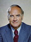
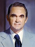
George McGovern defeated Alabama Governor, George Wallace, and previous Democratic nominee, Hubert Humphrey in the Wisconsin presidential primary on April 4, 1972

Democratic primary results [5]
PartyCandidateVotes%
Democratic George S. McGovern 333,528 29.55%
Democratic George Wallace 248,67622.03%
Democratic Hubert H. Humphrey 233,74820.71%
Democratic Edmund S. Muskie 115,81110.26%
Democratic Henry M. Jackson 88,0687.80%
Democratic John V. Lindsay 75,5796.70%
Democratic Eugene McCarthy 15,5431.38%
Democratic Shirley Chisholm 9,1980.82%
Democratic None of These Names Shown 2,4500.22%
Democratic Samuel Yorty 2,3490.21%
Democratic Patsy T. Mink 1,2130.11%
Democratic Wilbur D. Mills 9130.08%
Democratic Vance Hartke 7660.07%
Democratic Edward Kennedy (write-in)1830.02%
Democratic Scattering [a] 5590.05%
Total votes1,128,584 100.00%

Republican

Incumbent president Richard Nixon easily defeated token opposition from Pete McCloskey and John M. Ashbrook.

Republican primary results [6]
PartyCandidateVotes%
Republican Richard M. Nixon 277,601 96.91%
Republican Pete McCloskey 3,6511.27%
Republican John M. Ashbrook 2,6040.91%
Republican None of These Names Shown 2,3150.81%
Republican George Wallace (write-in)460.02%
Republican Scattering [a] 2270.08%
Total votes286,444 100.00%

Results

1972 United States presidential election in Wisconsin [7] [8]
PartyCandidateVotesPercentageElectoral votes
Republican Richard Nixon (incumbent)989,43053.40%11
Democratic George McGovern 810,17443.72%0
American John G. Schmitz 47,5252.56%0
People's [b] Benjamin Spock 2,7010.15%0
Socialist Labor [c] Louis Fisher 9980.05%0
Communist [d] Gus Hall 6630.04%0
Socialist Workers [e] Evelyn Reed 5060.03%0
Write-in Scattering [f] 8930.05%0
Totals1,852,890100.00%11

Results by county

County [7] [8] Richard Nixon
Republican
George McGovern
Democratic
John G. Schmitz
American
Benjamin Spock
People's
All Others
Various
MarginTotal votes cast
# %# %# %# %# %# %
Adams 2,20053.18%1,83344.31%962.32%30.07%50.12%3678.87%4,137
Ashland 3,47846.91%3,77150.86%1351.82%50.07%250.34%-293-3.95%7,414
Barron 8,41859.89%5,37638.25%2111.50%210.15%290.21%3,04221.64%14,055
Bayfield 3,04551.79%2,73646.54%741.26%40.07%200.34%3095.26%5,879
Brown 37,10156.49%26,51140.37%1,9072.90%940.14%620.09%10,59016.12%65,675
Buffalo 3,07954.28%2,46143.39%1101.94%40.07%180.32%61810.90%5,672
Burnett 2,97254.37%2,38943.71%921.68%80.15%50.09%58310.66%5,466
Calumet 6,44655.85%4,80441.62%2432.11%310.27%180.16%1,64214.23%11,542
Chippewa 8,45149.35%8,21047.95%4162.43%340.20%120.07%2411.40%17,123
Clark 7,13856.47%4,61736.52%8596.80%180.14%90.07%2,52119.95%12,641
Columbia 10,12258.02%7,08340.60%2161.24%110.06%150.09%3,03917.42%17,447
Crawford 3,70558.67%2,48739.38%1151.82%50.08%30.05%1,21819.29%6,315
Dane 56,02040.84%79,56758.00%1,0400.76%2190.16%3310.24%-23,547-17.17%137,177
Dodge 17,06861.54%9,89835.69%7152.58%290.10%270.10%7,17025.85%27,737
Door 6,50364.25%3,43033.89%1671.65%180.18%30.03%3,07330.36%10,121
Douglas 8,41942.58%11,05455.91%2021.02%360.18%600.30%-2,635-13.33%19,771
Dunn 6,66053.00%5,68145.21%1851.47%160.13%230.18%9797.79%12,565
Eau Claire 15,88351.28%14,30046.17%6712.17%570.18%600.19%1,5835.11%30,971
Florence 97154.06%75742.15%643.56%10.06%30.17%21411.91%1,796
Fond du Lac 21,00760.94%12,05034.96%1,2913.75%550.16%670.19%8,95725.98%34,470
Forest 1,85649.77%1,67845.00%1905.10%40.11%10.03%1784.77%3,729
Grant 11,87362.29%6,91536.28%2401.26%150.08%180.09%4,95826.01%19,061
Green 7,42266.14%3,63432.38%1451.29%130.12%80.07%3,78833.76%11,222
Green Lake 5,04667.67%2,17429.15%2273.04%60.08%40.05%2,87238.52%7,457
Iowa 4,38757.53%3,13141.06%971.27%70.09%40.05%1,25616.47%7,626
Iron 1,72349.93%1,64847.75%702.03%50.14%50.14%752.18%3,451
Jackson 3,93760.79%2,44537.75%841.30%90.14%10.02%1,49223.04%6,476
Jefferson 14,62159.32%9,30337.74%6112.48%220.09%910.37%5,31821.58%24,648
Juneau 4,83360.19%2,94336.65%2372.95%70.09%100.12%1,89023.54%8,030
Kenosha 24,04153.93%19,44143.61%9662.17%660.15%620.14%4,60010.32%44,576
Kewaunee 4,80257.15%3,36039.99%2292.73%110.13%10.01%1,44217.16%8,403
La Crosse 21,99263.29%12,15234.97%5411.56%360.10%250.07%9,84028.32%34,746
Lafayette 4,89862.91%2,80436.01%730.94%60.08%50.06%2,09426.90%7,786
Langlade 4,36857.26%3,01139.47%2383.12%60.08%60.08%1,35717.79%7,629
Lincoln 6,20657.25%4,17538.51%4374.03%110.10%110.10%2,03118.74%10,840
Manitowoc 16,59948.48%16,48948.16%1,0703.13%380.11%410.12%1100.32%34,237
Marathon 21,45451.24%18,50044.18%1,8134.33%420.10%630.15%2,9547.05%41,872
Marinette 8,74057.36%5,90038.72%5373.52%400.26%210.14%2,84018.64%15,238
Marquette 2,68262.53%1,53735.84%541.26%60.14%100.23%1,14526.70%4,289
Menominee 35536.37%60862.30%111.13%20.20%00.00%-253-25.93%976
Milwaukee 191,87446.02%210,80250.55%12,5673.01%7240.17%1,0100.24%-18,928-4.54%416,977
Monroe 7,62566.68%3,64031.83%1491.30%100.09%120.10%3,98534.85%11,436
Oconto 6,51159.38%4,04136.85%3853.51%130.12%150.14%2,47022.53%10,965
Oneida 6,81158.83%4,26236.81%4714.07%230.20%100.09%2,54922.02%11,577
Outagamie 27,53359.80%17,44737.89%8961.95%1010.22%670.15%10,08621.91%46,044
Ozaukee 15,75961.88%8,50333.39%1,1494.51%200.08%350.14%7,25628.49%25,466
Pepin 1,45849.21%1,40947.55%862.90%50.17%50.17%491.65%2,963
Pierce 5,89950.35%5,61147.89%1841.57%100.09%120.10%2882.46%11,716
Polk 6,56752.40%5,73845.78%2041.63%110.09%130.10%8296.62%12,533
Portage 9,34640.04%13,56458.11%3651.56%460.20%200.09%-4,218-18.07%23,341
Price 3,69454.39%2,83141.68%2503.68%20.03%150.22%86312.71%6,792
Racine 38,49056.41%27,77840.71%1,7852.62%1010.15%820.12%10,71215.70%68,236
Richland 5,06266.14%2,49232.56%901.18%30.04%70.09%2,57033.58%7,654
Rock 30,36158.03%21,03340.20%8231.57%650.12%370.07%9,32817.83%52,319
Rusk 3,00747.89%3,07548.97%1762.80%100.16%110.18%-68-1.08%6,279
Sauk 10,28558.70%6,98039.84%2041.16%120.07%410.23%3,30518.86%17,522
Sawyer 3,08162.52%1,76535.82%721.46%70.14%30.06%1,31626.70%4,928
Shawano 8,80766.95%3,94029.95%3782.87%70.05%220.17%4,86737.00%13,154
Sheboygan 21,50049.38%21,11448.50%7791.79%810.19%630.14%3860.89%43,537
St. Croix 8,55352.50%7,48845.96%2131.31%210.13%160.10%1,0656.54%16,291
Taylor 4,12555.76%2,93439.66%3134.23%40.05%220.30%1,19116.10%7,398
Trempealeau 5,72356.69%4,23241.92%1261.25%40.04%100.10%1,49114.77%10,095
Vernon 6,83665.71%3,40732.75%1271.22%100.10%230.22%3,42932.96%10,403
Vilas 4,42265.92%1,90728.43%3665.46%40.06%90.13%2,51537.49%6,708
Walworth 17,82365.95%8,59831.82%4851.79%380.14%790.29%9,22534.14%27,023
Washburn 3,22056.84%2,33641.24%961.69%60.11%70.12%88415.60%5,665
Washington 15,33856.76%10,43438.61%1,1614.30%450.17%460.17%4,90418.15%27,024
Waukesha 59,39960.85%34,57335.42%3,4043.49%1510.15%950.10%24,82625.43%97,622
Waupaca 11,04070.07%4,41828.04%2571.63%200.13%200.13%6,62242.03%15,755
Waushara 4,46666.27%2,09431.07%1662.46%80.12%50.07%2,37235.20%6,739
Winnebago 29,48857.28%20,45039.72%1,4002.72%930.18%510.10%9,03817.56%51,482
Wood 14,80654.88%10,41538.60%1,7196.37%250.09%150.06%4,39116.28%26,980
Totals989,43053.40%810,17443.72%47,5252.56%2,7010.15%3,0600.17%179,2569.67%1,852,890

Counties that flipped from Democratic to Republican

Counties that flipped from Republican to Democratic

Electors

These were the names of the electors on each ticket. [7]

Richard M. Nixon
& Spiro Agnew
Republican Party
George McGovern
& Sargent Shriver
Democratic Party
John G. Schmitz
& Thomas J. Anderson
American Party
  • Harold V. Froelich
  • Robert Warren
  • Merrill Stalbaum
  • Esther Doughty Luckhardt
  • Elaine Yerly
  • James C. Devitt
  • David Sullivan
  • Ernest Keppler
  • Daniel Theo
  • Gerald Lorge
  • Byron Wackett
  • Patrick J. Lucey
  • Martin Schreiber
  • Arnold Goodman
  • Charles P. Smith
  • Harvey L. Dueholm
  • Roger Szymanski
  • Ray Majerus
  • Anthony Werner
  • Mrs. Milton Schneider
  • Larry Longley
  • Jeanette Swed
  • John Couture
  • Joseph Birkenstock
  • Robert Morgan
  • Karl E. Koehler
  • Keith Ellison
  • John Zierhut
  • Earl Denny
  • Harvey Raidy
  • R. David Pennings
  • Edward Duquaine
  • David Beirle
Benjamin Spock
& Julius Hobson
People's Party
Louis Fisher
& Genevieve Gunderson
Socialist Labor Party
Gus Hall
& Jarvis Tyner
Communist Party
Evelyn Reed
& Clifton DeBerry
Socialist Workers Party
  • James E. Bouton
  • Rohn F. Webb
  • Dale E. Najdowski
  • Elizabeth Boardman
  • David Webb
  • Richard Crawford
  • John Gnewuch
  • Gene J. Shermeister
  • Pope Wright
  • Lester Sieglaff
  • Daniel D. Olson
  • Louis Fisher
  • Genevieve Gunderson
  • Martin Tobert
  • Henry A. Ochsner
  • C. James Matuschka
  • Arthur Wepfer
  • Adolf Wiggert
  • Alfred Teichert
  • Clarence Wardall
  • Anton Jonas
  • Carol Cozzini
  • Eino Maatta
  • Lucille Berrien
  • Alex Regis Broeske
  • Marianne Rice
  • Irene Zvaigznitis
  • John G. Repensek
  • Mary E. Blair
  • Ida Gudex
  • Joe A. Lima
  • Lillian Rahkonen
  • Ernst Ave Lallemont
  • Patrick M. Quinn
  • Martha M. Quinn
  • John P. Holton
  • Gregory Spicer
  • Susan E. James
  • Sam K. Hunt
  • Walter L. Chesser
  • Douglas G. Zoerb
  • Mark E. Kiland
  • Linda T. Montello
  • Thomas T. Tank

See also

Notes

  1. 1 2 Not listed directly in the Blue Book but can be obtained by subtracting the candidate totals from the statewide and county totals.
  2. "Independent People's Party"
  3. "Independent Socialist Labor"
  4. "Independent Communist Party USA"
  5. "Independent Socialist Workers"
  6. Not listed in the 1973 Blue Book, but are shown separately by county in the Board of Canvassers report

References

  1. "1972 Presidential General Election Results – Wisconsin". Dave Leip’s U.S. Election Atlas. Retrieved April 28, 2016.
  2. Counting the Votes; Wisconsin Archived 2017-01-01 at the Wayback Machine
  3. ‘1972 Presidential Election Statistics’
  4. Sullivan, Robert David; ‘How the Red and Blue Map Evolved Over the Past Century’; America Magazine in The National Catholic Review; June 29, 2016
  5. Wisconsin Legislative Reference Bureau. "Democratic Presidential Preference Vote By County". The State of Wisconsin Blue Book 1973. Madison, Wisconsin. pp. 786–787.
  6. Wisconsin Legislative Reference Bureau. "Republican Presidential Preference Vote By County". The State of Wisconsin Blue Book 1973. Madison, Wisconsin. p. 792.
  7. 1 2 3 Wisconsin Historical Society, Statement of Board of State Canvassers for President, Vice President and Presidential Electors - General Election - November 7, 1972
  8. 1 2 Wisconsin Legislative Reference Bureau. "Vote For President And Vice President By County". The State of Wisconsin Blue Book 1973. Madison, Wisconsin. p. 817.