Sauk County, Wisconsin

Last updated

Sauk County
Sauk County Courthouse.jpg
Map of Wisconsin highlighting Sauk County.svg
Location within the U.S. state of Wisconsin
Wisconsin in United States.svg
Wisconsin's location within the U.S.
Coordinates: 43°26′N89°56′W / 43.43°N 89.94°W / 43.43; -89.94
CountryFlag of the United States.svg United States
StateFlag of Wisconsin.svg  Wisconsin
Founded1844
Named for Sauk people
Seat Baraboo
Largest cityBaraboo
Area
  Total849 sq mi (2,200 km2)
  Land831 sq mi (2,150 km2)
  Water18 sq mi (50 km2)  2.1%
Population
 (2020)
  Total65,763
  Density77/sq mi (30/km2)
Time zone UTC−6 (Central)
  Summer (DST) UTC−5 (CDT)
Congressional district 2nd
Website www.co.sauk.wi.us

Sauk County is a county in Wisconsin. It is named after a large village of the Sauk people. [1] As of the 2020 census, the population was 65,763. [2] Its county seat and largest city is Baraboo. [3] The county was created in 1840 from Wisconsin Territory and organized in 1844. [4] Sauk County comprises the Baraboo, WI Micropolitan Statistical Area and is included in the Madison metropolitan area.

Contents

History

Sauk County was a New England settlement. The original founders of Sauk County consisted entirely of settlers from New England as well as some from upstate New York who had parents who moved to that region from New England shortly after the American Revolution. These people were "Yankee" settlers, that is to say they were descended from the English Puritans who settled New England in the 1600s. While most of them came to Wisconsin directly from New England, there were many who came from upstate New York. These were people whose parents had moved from New England to upstate New York in the immediate aftermath of the American Revolution. They were part of a wave of New England farmers who headed west into what was then the wilds of the Northwest Territory during the early 1800s. In the case of Wisconsin this migration primarily occurred in the 1830s. Due to the prevalence of New Englanders and New England transplants from upstate New York, Wisconsin was very culturally continuous with early New England culture for much of its early history. [5] [6]

The Yankee migration to Wisconsin in the 1830s was a result of several factors, one of which was the overpopulation of New England. The old stock Yankee population had large families, often bearing up to ten children in one household. Most people were expected to have their own piece of land to farm, and due to the massive and nonstop population boom, land in New England became scarce as every son claimed his own farmstead. As a result, there was not enough land for every family to have a self-sustaining farm, and Yankee settlers began leaving New England for the Midwestern United States. [5]

They were aided in this effort by the construction and completion of the Erie Canal which made traveling to the region much easier, causing an additional surge in migrants coming from New England. Added to this was the end of the Black Hawk War, which made the region much safer to travel through and settle in for white settlers.

They got to what is now Sauk County in the 1830s by sailing up the Wisconsin River from the Mississippi River on small barges which they constructed themselves out of materials obtained from the surrounding woodlands. When they arrived in what is now Sauk County there was nothing but dense virgin forest, the "Yankee" New Englanders laid out farms, constructed roads, erected government buildings and established post routes. They brought with them many of their Yankee New England values, such as a passion for education, establishing many schools as well as staunch support for abolitionism. They were mostly members of the Congregationalist Church though some were Episcopalian. Due to the second Great Awakening some of them had converted to Methodism and some became Baptist before moving to what is now Sauk County. Sauk County, like much of Wisconsin, would be culturally very continuous with early New England culture for most of its early history. [7] [8] [9] [10]

In the late 1890s, German immigrants began to settle in Sauk County, making up less than one out of thirty settlers in the county before this date. Generally there was little conflict between them and the "Yankee" settlers, however when conflict did arise it focused around the issue of prohibition of alcohol. On this issue the Yankees were divided and the Germans almost unanimously were opposed to it, tipping the balance in favor of opposition to prohibition. [11] Later the two communities would be divided on the issue of World War I in which, once again, the Yankee community would be divided and the Germans were unanimously opposed to American entry into the war. The Yankee community was generally pro-British, however many of the Yankees also did not want America to enter the war themselves. The Germans were sympathetic to Germany and did not want the United States to enter into a war against Germany, but the Germans were not anti-British. Prior to World War I, many German community leaders in Wisconsin spoke openly and enthusiastically about how much better America was than Germany, due primarily (in their eyes) to the presence of English law and the English political culture the Americans had inherited from the colonial era, which they contrasted with the turmoil and oppression in Germany which they had so recently fled. In the early 1900s immigrants from Ireland, Sweden, Norway and Poland also arrived in Sauk County. [12] The area around Baraboo was first settled by Abe Wood in 1838, and was originally known as the village of Adams. [13] In 1846 it became the county seat of Sauk County after a fierce fight with the nearby village of Reedsburg. [14] In 1852, the village was renamed "Baraboo", after the nearby river. It was incorporated as a city in 1882. [15]

New England settlers set up several sawmills early in the history of what is now Baraboo because of its location near the Baraboo and Wisconsin Rivers.

The city was the home of the Ringling Brothers. From 1884 to 1917 it was the headquarters of their circus and several others, leading to the nickname "Circus City". [15] Today Circus World Museum is located in Baraboo. A living history museum, it has a collection of circus wagons and other circus artifacts. It also has the largest library of circus information in the United States. [16] The museum previously hosted the Great Circus Parade, which carried circus wagons and performers through the streets of Baraboo, across the state by train, and then through downtown Milwaukee.

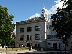
The Al. Ringling Theatre is a grand scale movie palace in downtown Baraboo, made possible through the financial assistance of the Ringling family. The Al Ringling home still exists.

Located near Baraboo is the Badger Army Ammunition Plant, which was the largest munitions factory in the world during World War II, when it was known as "Badger Ordnance Works". [17] The plant is no longer in use.

The Culver's restaurant franchise has its headquarters in Prairie du Sac, and was first opened in Sauk City in 1984. [18] That same year, Cirrus Aircraft, now of Duluth, Minnesota, was founded in a rural Baraboo barn by brothers Alan and Dale Klapmeier to produce the VK-30 kit aircraft. [19] [20] [21]

Geography

Soils of Sauk County Sauk Co WI Pie Chart No Text Version.pdf
Soils of Sauk County

According to the U.S. Census Bureau, the county has a total area of 849 square miles (2,200 km2), of which 831 square miles (2,150 km2) is land and 18 square miles (47 km2) (2.1%) is water. [22] Pewits Nest is located in Sauk County. Sauk Point is the county's highest point. The summit is nestled in the Baraboo bluffs and stands to 1,593 feet (486 m) above sea level.

Major highways

Typical Sauk County countryside SaukCountyWisconsin.jpg
Typical Sauk County countryside
Sauk County sign on U.S. Route 12 Sauk County Wisconsin Sign US12 WIS16.jpg
Sauk County sign on U.S. Route 12

Railroads

Buses

Airports

Adjacent counties

Demographics

Historical population
CensusPop.Note
1840 102
1850 4,3714,185.3%
1860 18,963333.8%
1870 23,86025.8%
1880 28,72920.4%
1890 30,5756.4%
1900 33,0068.0%
1910 32,869−0.4%
1920 32,548−1.0%
1930 32,030−1.6%
1940 33,7005.2%
1950 38,12013.1%
1960 36,179−5.1%
1970 39,0578.0%
1980 43,46911.3%
1990 46,9758.1%
2000 55,22517.6%
2010 61,97612.2%
2020 65,7636.1%
U.S. Decennial Census [23]
1790–1960 [24] 1900–1990 [25]
1990–2000 [26] 2010–2020 [2]

2020 census

As of the census of 2020, [27] the population was 65,763. The population density was 79.1 people per square mile (30.5 people/km2). There were 30,784 housing units at an average density of 37.0 units per square mile (14.3 units/km2). The racial makeup of the county was 89.1% White, 1.3% Native American, 0.9% Black or African American, 0.6% Asian, 3.1% from other races, and 4.9% from two or more races. Ethnically, the population was 6.2% Hispanic or Latino of any race.

2000 Census Age Pyramid for Sauk County USA Sauk County, Wisconsin age pyramid.svg
2000 Census Age Pyramid for Sauk County

2000 census

As of the census [28] of 2000, there were 55,225 people, 21,644 households, and 14,869 families residing in the county. The population density was 66 people per square mile (25 people/km2). There were 24,297 housing units at an average density of 29 units per square mile (11 units/km2). The racial makeup of the county was 97.37% White, 0.26% Black or African American, 0.87% Native American, 0.26% Asian, 0.02% Pacific Islander, 0.59% from other races, and 0.64% from two or more races. 1.70% of the population were Hispanic or Latino of any race. 50.7% were of German, 8.5% Irish, 6.5% Norwegian, 6.2% American and 5.9% English ancestry. 95.5% spoke English, 1.9% Spanish and 1.4% German as their first language. There were 21,644 households, out of which 32.60% had children under the age of 18 living with them, 56.80% were married couples living together, 8.10% had a female householder with no husband present, and 31.30% were non-families. 25.20% of all households were made up of individuals, and 10.60% had someone living alone who was 65 years of age or older. The average household size was 2.51 and the average family size was 3.03.

In the county, the population was spread out, with 26.00% under the age of 18, 7.40% from 18 to 24, 29.30% from 25 to 44, 22.80% from 45 to 64, and 14.50% who were 65 years of age or older. The median age was 37 years. For every 100 females, there were 97.70 males. For every 100 females age 18 and over, there were 95.20 males.

Communities

Farming in Sauk County near Reedsburg SaukCountyWisconsinBarn.03.2007.jpg
Farming in Sauk County near Reedsburg
Fairgrounds in Baraboo SaukCountyWisconsinFairgroundsBarabooWIS33.jpg
Fairgrounds in Baraboo

Cities

Villages

Towns

Census-designated places

Other unincorporated communities

Politics

Sauk County voted for Republicans in all but five elections prior to 1992, thereafter trending Democratic. In 2016 Donald Trump won the county by 109 votes, but in 2020 it flipped blue once again. Since 1992 the county has voted for the statewide winner in every election, and is thus considered a bellwether politically. [29]

United States presidential election results for Sauk County, Wisconsin [30]
Year Republican Democratic Third party
No.%No.%No.%
2020 17,49348.32%18,10850.02%6021.66%
2016 14,79947.20%14,69046.85%1,8685.96%
2012 12,83840.21%18,73658.68%3531.11%
2008 11,56237.75%18,61760.79%4471.46%
2004 14,41547.39%15,70851.64%2940.97%
2000 11,58645.16%13,03550.81%1,0324.02%
1996 7,44836.72%9,88948.75%2,94814.53%
1992 8,88637.94%9,12838.97%5,40823.09%
1988 10,22554.72%8,32444.54%1380.74%
1984 11,06960.44%7,15839.09%860.47%
1980 9,99249.48%8,45641.87%1,7478.65%
1976 9,57749.90%9,20447.96%4112.14%
1972 10,28558.79%6,98039.90%2281.30%
1968 8,60853.64%6,40639.92%1,0346.44%
1964 6,34540.53%9,28859.33%230.15%
1960 10,40361.68%6,44138.19%230.14%
1956 10,64466.46%5,29233.04%800.50%
1952 12,34769.89%5,26729.81%520.29%
1948 7,14053.66%5,83143.82%3362.52%
1944 9,75162.72%5,69036.60%1050.68%
1940 9,36359.61%6,10638.87%2381.52%
1936 5,62637.98%8,35556.41%8315.61%
1932 5,06339.35%7,63859.36%1661.29%
1928 7,49658.89%5,15140.47%820.64%
1924 3,93535.60%5555.02%6,56259.37%
1920 8,07484.79%9469.93%5025.27%
1916 3,77959.66%2,25735.63%2984.70%
1912 2,17137.91%2,46443.02%1,09219.07%
1908 3,85457.06%2,57138.07%3294.87%
1904 4,80567.53%1,91426.90%3965.57%
1900 4,32960.89%2,49135.04%2904.08%
1896 4,62360.95%2,61134.42%3514.63%
1892 3,27747.76%3,13945.74%4466.50%

Economy

The county's largest employer is the Ho-Chunk Nation, which employs roughly 3100 people combined in Jackson and Sauk counties. [31]

See also

Related Research Articles

<span class="mw-page-title-main">Adams County, Wisconsin</span> County in Wisconsin, United States

Adams County is a county in the U.S. state of Wisconsin. As of the 2020 census, the population was 20,654. Its county seat is Friendship. The county was created in 1848 and organized in 1853. Sources differ as to whether its name is in honor of the second President of the United States, John Adams, or his son, the sixth President, John Quincy Adams.

<span class="mw-page-title-main">Green County, Wisconsin</span> County in Wisconsin, United States

Green County is a county located in the U.S. state of Wisconsin. As of the 2020 census, the population was 37,093. Its county seat is Monroe. Green County is included in the Madison, WI Metropolitan Statistical Area.

<span class="mw-page-title-main">Dane County, Wisconsin</span> County in Wisconsin, United States

Dane County is a county in the U.S. state of Wisconsin. As of the 2020 census, the population was 561,504, making it the second-most populous county in Wisconsin after Milwaukee. The county seat is Madison, which is also the state capital.

<span class="mw-page-title-main">Columbia County, Wisconsin</span> County in Wisconsin, United States

Columbia County is a county located in the U.S. state of Wisconsin. As of the 2020 census, the population was 58,490. Its county seat and largest city is Portage. The county was created in 1846 as part of Wisconsin Territory.

<span class="mw-page-title-main">Goodhue County, Minnesota</span> County in Minnesota, United States

Goodhue County is a county in the U.S. state of Minnesota. As of the 2020 census, the population was 47,582. Its county seat is Red Wing. Nearly all of Prairie Island Indian Community is within the county.

<span class="mw-page-title-main">Roxbury, Wisconsin</span> Town in Wisconsin, United States

The Town of Roxbury is located in Dane County, Wisconsin, United States. The population was 1,871 at the 2020 census. The unincorporated communities of Alden Corners and Roxbury are located in the town. The unincorporated community of Lutheran Hill is also located partially in the town.

<span class="mw-page-title-main">Concord, Wisconsin</span> Town in Wisconsin, United States

Concord is a town in Jefferson County, Wisconsin, United States. The population was 2,072 at the 2010 census.

<span class="mw-page-title-main">Lake Delton, Wisconsin</span> Village in Wisconsin, United States

Lake Delton is a village located on the Wisconsin River in Sauk County, Wisconsin, United States. The population was 3,501 at the 2020 census. Lake Delton, along with the nearby Wisconsin Dells, is a resort area and a center for tourism in the upper Midwest. Lake Delton is included in the Baraboo Micropolitan Area which comprises part of the larger Madison Combined Statistical Area.

<span class="mw-page-title-main">Plain, Wisconsin</span> Village in Wisconsin, United States

Plain is a village in Sauk County, Wisconsin, United States. The population was 773 at the 2010 census.

<span class="mw-page-title-main">Sauk City, Wisconsin</span> Village in Wisconsin, United States

Sauk City is a village in Sauk County, Wisconsin, United States. The population was 3,518 as of the 2020 census. The first incorporated village in the state, the community was founded by Agoston Haraszthy and his business partner, Robert Bryant.

<span class="mw-page-title-main">Lodi, Wisconsin</span> City in Wisconsin, United States

Lodi is a city in Columbia County, Wisconsin, United States. The population was 3,189 at the 2020 census. Lodi is part of the Madison Metropolitan Statistical Area.

<span class="mw-page-title-main">Baraboo, Wisconsin</span> City in Wisconsin, United States

Baraboo is the largest city in and the county seat of Sauk County, Wisconsin, United States. The largest city in the county, Baraboo is the principal city of the Baraboo Micropolitan Statistical Area which comprises a portion of the Madison Combined Statistical area. Its 2020 population was 12,556. It is situated on the Baraboo River.

<span class="mw-page-title-main">Ironton, Wisconsin</span> Village in Wisconsin, United States

Ironton is a village in Sauk County, Wisconsin, United States, along the Little Baraboo River. The population was 253 at the 2010 census. The village is located within the Town of Ironton.

<span class="mw-page-title-main">Prairie du Sac, Wisconsin</span> Village in Wisconsin, United States

Prairie du Sac is a village in Sauk County, Wisconsin, United States. The population was 4,420 at the 2020 census. The village is surrounded by the Town of Prairie du Sac, the Wisconsin River, and the village of Sauk City; together, Prairie du Sac and Sauk City are referred to as Sauk Prairie.

<span class="mw-page-title-main">Reedsburg, Wisconsin</span> City in Sauk County, Wisconsin, United States

Reedsburg is a city in Sauk County, Wisconsin, United States. Located along the Baraboo River, it was founded in 1868, and was named for early settler David C. Reed. The city is surrounded by the Town of Reedsburg. It is part of the Baraboo Micropolitan Statistical Area.

<span class="mw-page-title-main">Ringling Brothers Circus</span> Traveling circus company (1884–1919)

Ringling Bros. World's Greatest Shows is a circus founded in Baraboo, Wisconsin, United States in 1884 by five of the seven Ringling brothers: Albert, August, Otto, Alfred T., Charles, John, and Henry. The Ringling brothers were sons of a German immigrant, August Frederick Rüngeling, who changed his name to Ringling once he settled in America. Four brothers were born in McGregor, Iowa: Alf T., Charles, John and Henry. The Ringling family lived in McGregor, Iowa, for twelve years, from 1860 until 1872. The family then lived in Prairie du Chien, Wisconsin, and moved to Baraboo, Wisconsin, in 1875. In 1907 Ringling Bros. acquired the Barnum & Bailey Circus, merging them in 1919 to become Ringling Bros. and Barnum & Bailey Circus, promoted as The Greatest Show on Earth. Ringling Bros. and Barnum & Bailey closed on May 21, 2017, following weakening attendance and high operating costs.

<span class="mw-page-title-main">Wisconsin Highway 136</span> State highway in Wisconsin, United States

State Trunk Highway 136 is a state highway in the U.S. state of Wisconsin. It runs east–west in southwest Wisconsin from near Reedsburg to Baraboo. The route was first designated in 1917 but not as WIS 136 until 1935. The highway was extended in 2017.

<span class="mw-page-title-main">South Central Library System</span>

The South Central Library System (SCLS) is a consortium of 53 public libraries in 7 Wisconsin counties: Adams, Columbia, Dane, Green, Portage, Sauk, and Wood.

<span class="mw-page-title-main">National Register of Historic Places listings in Sauk County, Wisconsin</span>

This is a list of the National Register of Historic Places listings in Sauk County, Wisconsin. It is intended to provide a comprehensive listing of entries in the National Register of Historic Places that are located in Sauk County, Wisconsin. The locations of National Register properties for which the latitude and longitude coordinates are included below may be seen in a map.

The Madison, Wisconsin, metropolitan area, also known as Greater Madison, is the metropolitan area surrounding the city of Madison, Wisconsin. Madison is the state capital of Wisconsin and is Wisconsin's second largest city, and the metropolitan area is also the state's second largest which the Madison MSA borders to its east.

References

  1. "Winnebago Took Its Name from an Indian Tribe". The Post-Crescent. December 28, 1963. p. 14. Retrieved August 25, 2014 via Newspapers.com. Open Access logo PLoS transparent.svg
  2. 1 2 "State & County QuickFacts". United States Census Bureau. Archived from the original on July 28, 2011. Retrieved January 23, 2014.
  3. "Find a County". National Association of Counties. Retrieved June 7, 2011.
  4. "Wisconsin: Individual County Chronologies". Wisconsin Atlas of Historical County Boundaries. The Newberry Library. 2007. Archived from the original on April 14, 2017. Retrieved August 15, 2015.
  5. 1 2 The Yankee Exodus: An Account of Migration from New England by Stewart Hall Holbrook University of Washington Press, 1968
  6. American Zion: The Old Testament as a Political Text from the Revolution to ... By Eran Shalev, Yale University Press, Mar 26, 2013 ISBN   9780300186925 page 70-71
  7. Canfield, William Harvey (1891). Outline Sketches of Sauk County, Wisconsin, Including Its History from the First Marks of Man's Hand to 1891 and Its Typography, Both Written and Illustrated: Volume Second: Baraboo, Ninth Sketch.
  8. The History of Sauk County, Wisconsin: Containing an Account of Its Settlement, Growth, Development and Resources; an Extensive and Minute Sketch of Its Cities, Towns and Villages, Their Improvements, Industries, Manufactories, Churches, Schools and Societies; Its War Record, Biographical Sketches, Portraits of Prominent Men and Early Settlers; the Whole Preceded by a History of Wisconsin, Statistics of the State, and an Abstract of Its Laws and Constitution and of the Constitution of the United States. Chicago: Western Historical Company. 1880.
  9. Cole, Harry Ellsworth, ed. (1918). A Standard History of Sauk County Wisconsin, Volume II. Chicago: Lewis Publishing Company.
  10. Dean W. O'Brien, Polly E. O'Brien. Looking into History: The Sauk County Area Sauk County Historical Society, 2001.
  11. Wisconsin Then and Now, Volumes 21-24 State Historical Society of Wisconsin, 1974 pages 102-103, page 138
  12. The German Historians and England: A Study in Nineteenth-century Views By Charles E. McClelland pages 19, 136, 138. 176, 196
  13. The Wisconsin Blue Book 1929 . Madison: Democrat Printing Company, 1929, p. 629.
  14. "County Government: Why Adams County?" in Adams County Historical Society,From Past to Present: Adams County. Friendship, Wisconsin: New Past Press, 1999.
  15. 1 2 "Term: Baraboo [brief history]" in Dictionary of Wisconsin History.
  16. Bill Steigerwald. "Travels Without Charley: A beautiful lake and a movie palace await in Baraboo". Pittsburgh Post-Gazette, October 17, 2010. Retrieved September 10, 2013.
  17. "GSA - Badger Site Information". Archived from the original on June 21, 2006.
  18. "Our Story | History of Culver's Family & Restaurant | Culver's". Culver's. Retrieved August 14, 2018.
  19. The Museum of Flight. Lecture by Cirrus Aircraft CEO Dale Klapmeier archived at .
  20. Airport Journals. The Dream Brothers: Alan and Dale Klapmeier
  21. Wisconsin Aviation Hall of Fame. Exciting News From the National Aviation Hall of Fame. December 19, 2013.
  22. "2010 Census Gazetteer Files". United States Census Bureau. August 22, 2012. Retrieved August 9, 2015.
  23. "U.S. Decennial Census". United States Census Bureau. Retrieved August 9, 2015.
  24. "Historical Census Browser". University of Virginia Library. Retrieved August 9, 2015.
  25. Forstall, Richard L., ed. (March 27, 1995). "Population of Counties by Decennial Census: 1900 to 1990". United States Census Bureau. Retrieved August 9, 2015.
  26. "Census 2000 PHC-T-4. Ranking Tables for Counties: 1990 and 2000" (PDF). United States Census Bureau. April 2, 2001. Archived (PDF) from the original on October 9, 2022. Retrieved August 9, 2015.
  27. "2020 Decennial Census: Sauk County, Wisconsin". data.census.gov. U.S. Census Bureau. Retrieved July 5, 2022.
  28. "U.S. Census website". United States Census Bureau . Retrieved May 14, 2011.
  29. David Wasserman (October 6, 2020), "The 10 Bellwether Counties That Show How Trump Is in Serious Trouble", The New York Times
  30. Leip, David. "Dave Leip's Atlas of U.S. Presidential Elections". uselectionatlas.org. Retrieved November 11, 2020.
  31. "Ho-Chunk Nation" . Retrieved September 14, 2023.

Further reading

43°26′N89°56′W / 43.43°N 89.94°W / 43.43; -89.94