Pierce County | |
---|---|
Coordinates: 44°43′N92°25′W / 44.72°N 92.42°W | |
Country | United States |
State | Wisconsin |
Founded | 1853 |
Named for | Franklin Pierce [1] |
Seat | Ellsworth |
Largest city | River Falls |
Area | |
• Total | 592 sq mi (1,530 km2) |
• Land | 574 sq mi (1,490 km2) |
• Water | 18 sq mi (50 km2) 3.1% |
Population | |
• Total | 42,212 |
• Estimate (2023) | 43,026 |
• Density | 73.5/sq mi (28.4/km2) |
Time zone | UTC−6 (Central) |
• Summer (DST) | UTC−5 (CDT) |
Congressional district | 3rd |
Website | www |
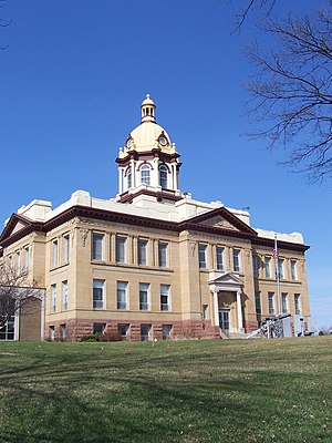
Pierce County is a county in the U.S. state of Wisconsin. As of the 2020 census, the population was 42,212. [2] Its county seat is Ellsworth. [3]
Pierce County is part of the Minneapolis–St. Paul–Bloomington, MN-WI Metropolitan Statistical Area.
Native American were the first to live in what became Pierce County, as evidenced in the burial mounds near Diamond Bluff. Evidence indicates that this area has been inhabited for 10,000 to 12,000 years. In 1840, St. Croix County covered a large portion of northwest Wisconsin Territory. In 1853, the Wisconsin State Legislature split St. Croix County into Pierce, Polk, and Saint Croix counties. Pierce County was named for Franklin Pierce, the fourteenth president of the United States. [4] [5]
According to the U.S. Census Bureau, the county has a total area of 592 square miles (1,530 km2), of which 574 square miles (1,490 km2) is land and 18 square miles (47 km2) (3.1%) is water. [6]
Census | Pop. | Note | %± |
---|---|---|---|
1860 | 4,672 | — | |
1870 | 9,958 | 113.1% | |
1880 | 17,744 | 78.2% | |
1890 | 20,385 | 14.9% | |
1900 | 23,943 | 17.5% | |
1910 | 22,079 | −7.8% | |
1920 | 21,663 | −1.9% | |
1930 | 21,043 | −2.9% | |
1940 | 21,471 | 2.0% | |
1950 | 21,448 | −0.1% | |
1960 | 22,503 | 4.9% | |
1970 | 26,652 | 18.4% | |
1980 | 31,149 | 16.9% | |
1990 | 32,765 | 5.2% | |
2000 | 36,804 | 12.3% | |
2010 | 41,019 | 11.5% | |
2020 | 42,212 | 2.9% | |
U.S. Decennial Census [7] 1790–1960 [8] 1900–1990 [9] 1990–2000 [10] 2010 [11] 2020 [2] |
As of the census of 2020, [2] the population was 42,212. The population density was 73.5 people per square mile (28.4 people/km2). There were 16,780 housing units at an average density of 29.2 units per square mile (11.3 units/km2). The racial makeup of the county was 92.3% White, 1.0% Black or African American, 0.7% Asian, 0.5% Native American, 1.1% from other races, and 4.3% from two or more races. Ethnically, the population was 2.9% Hispanic or Latino of any race.
As of the census [12] of 2000, there were 36,804 people, 13,015 households, and 9,032 families residing in the county. The population density was 64 people per square mile (25 people/km2). There were 13,493 housing units at an average density of 23 units per square mile (8.9 units/km2). The racial makeup of the county was 98.01% White, 0.25% Black or African American, 0.29% Native American, 0.43% Asian, 0.03% Pacific Islander, 0.28% from other races, and 0.72% from two or more races. 0.82% of the population were Hispanic or Latino of any race. 41.0% were of German, 16.2% Norwegian, 7.1% Swedish and 7.1% Irish ancestry.
There were 13,015 households, out of which 35.00% had children under the age of 18 living with them, 58.10% were married couples living together, 7.50% had a female householder with no husband present, and 30.60% were non-families. 21.30% of all households were made up of individuals, and 7.50% had someone living alone who was 65 years of age or older. The average household size was 2.65 and the average family size was 3.10.
In the county, the population was spread out, with 24.40% under the age of 18, 17.00% from 18 to 24, 28.10% from 25 to 44, 20.80% from 45 to 64, and 9.60% who were 65 years of age or older. The median age was 32 years. For every 100 females there were 97.30 males. For every 100 females age 18 and over, there were 94.20 males.
In 2017, there were 386 births, giving a general fertility rate of 43.7 births per 1000 women aged 15–44, the lowest rate out of all 72 Wisconsin counties. [13]
Year | Republican | Democratic | Third party(ies) | |||
---|---|---|---|---|---|---|
No. | % | No. | % | No. | % | |
2020 | 12,815 | 54.96% | 9,796 | 42.01% | 706 | 3.03% |
2016 | 11,272 | 52.73% | 8,399 | 39.29% | 1,705 | 7.98% |
2012 | 10,397 | 49.46% | 10,235 | 48.69% | 388 | 1.85% |
2008 | 9,812 | 44.38% | 11,803 | 53.39% | 492 | 2.23% |
2004 | 10,437 | 47.71% | 11,176 | 51.09% | 263 | 1.20% |
2000 | 8,169 | 45.48% | 8,559 | 47.65% | 1,234 | 6.87% |
1996 | 4,599 | 30.66% | 7,970 | 53.13% | 2,431 | 16.21% |
1992 | 4,844 | 28.05% | 7,824 | 45.30% | 4,604 | 26.66% |
1988 | 6,045 | 40.87% | 8,659 | 58.55% | 85 | 0.57% |
1984 | 7,612 | 50.74% | 7,289 | 48.58% | 102 | 0.68% |
1980 | 6,209 | 39.68% | 7,312 | 46.73% | 2,125 | 13.58% |
1976 | 5,676 | 40.36% | 8,039 | 57.16% | 349 | 2.48% |
1972 | 5,899 | 50.35% | 5,611 | 47.89% | 206 | 1.76% |
1968 | 4,990 | 48.76% | 4,783 | 46.74% | 461 | 4.50% |
1964 | 3,291 | 34.05% | 6,351 | 65.70% | 24 | 0.25% |
1960 | 5,632 | 56.56% | 4,317 | 43.35% | 9 | 0.09% |
1956 | 5,782 | 61.13% | 3,644 | 38.53% | 32 | 0.34% |
1952 | 6,763 | 67.49% | 3,241 | 32.34% | 17 | 0.17% |
1948 | 3,753 | 45.18% | 4,395 | 52.91% | 158 | 1.90% |
1944 | 5,137 | 62.40% | 3,033 | 36.84% | 63 | 0.77% |
1940 | 6,624 | 66.25% | 3,259 | 32.59% | 116 | 1.16% |
1936 | 3,935 | 42.70% | 4,061 | 44.06% | 1,220 | 13.24% |
1932 | 3,537 | 44.32% | 4,115 | 51.57% | 328 | 4.11% |
1928 | 6,491 | 67.65% | 3,017 | 31.44% | 87 | 0.91% |
1924 | 2,788 | 40.97% | 298 | 4.38% | 3,719 | 54.65% |
1920 | 4,441 | 82.62% | 644 | 11.98% | 290 | 5.40% |
1916 | 1,945 | 51.88% | 1,650 | 44.01% | 154 | 4.11% |
1912 | 986 | 29.13% | 985 | 29.10% | 1,414 | 41.77% |
1908 | 2,988 | 71.62% | 978 | 23.44% | 206 | 4.94% |
1904 | 3,492 | 82.28% | 594 | 14.00% | 158 | 3.72% |
1900 | 3,433 | 72.95% | 1,041 | 22.12% | 232 | 4.93% |
1896 | 3,724 | 69.79% | 1,412 | 26.46% | 200 | 3.75% |
1892 | 2,315 | 57.66% | 1,210 | 30.14% | 490 | 12.20% |
Trempealeau County is a county in the U.S. state of Wisconsin. As of the 2020 census, the population was 30,760. Its county seat is Whitehall.
St. Croix County is a county in the U.S. state of Wisconsin. As of the 2020 census, the population was 93,536. Its county seat is Hudson. The county was created in 1840 and organized in 1849. St. Croix County is part of the Minneapolis-St. Paul-Bloomington, MN-WI Metropolitan Statistical Area. Between 2000 and 2010, it was the fastest-growing county in Wisconsin.
Richland County is a county in the U.S. state of Wisconsin. As of the 2020 census, the population was 17,304. Its county seat is Richland Center. The county was created from the Wisconsin Territory in 1842 and organized in 1850. It is named for the high quality of its soil.
Racine County is a county in southeastern Wisconsin. As of the 2020 census, its population was 197,727, making it Wisconsin's fifth-most populous county. Its county seat is Racine. The county was founded in 1836, then a part of the Wisconsin Territory. Racine County comprises the Racine metropolitan statistical area. This area is part of the Milwaukee-Racine-Waukesha combined statistical area. According to the U.S. Census Bureau, the county has an area of 792 square miles (2,050 km2), of which 333 square miles (860 km2) is land and 460 square miles (1,200 km2) (58%) is water. The county's unemployment rate was 5.6% in June 2021.
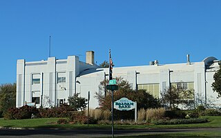
Polk County is a county in the U.S. state of Wisconsin. As of the 2020 census, the population was 44,977. Its county seat is Balsam Lake. The county was created in 1853 and named for United States President James K. Polk.
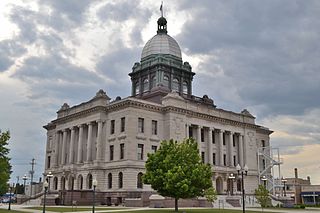
Manitowoc County is a county in the U.S. state of Wisconsin. As of the 2020 census, the population was 81,359. Its county seat is Manitowoc. The county was created in 1836 prior to Wisconsin's statehood and organized in 1848. Manitowoc County comprises the Manitowoc, WI Micropolitan Statistical Area.
Langlade County is a county located in the U.S. state of Wisconsin. As of the 2020 census, the population was 19,491. Its county seat is Antigo.
Jackson County is a county located in the U.S. state of Wisconsin. As of the 2020 census, the population was 21,145. Its county seat is Black River Falls. Jackson County was formed from Crawford County in 1853. It was named for President Andrew Jackson.
Green Lake County is a county located in the U.S. state of Wisconsin. As of the 2020 census, the population was 19,018. Its county seat is Green Lake. In 2020, the center of population of Wisconsin was located in Green Lake County, near the city of Markesan.
Dunn County is a county in the U.S. state of Wisconsin. As of the 2020 census, the population was 45,440. Its county seat is Menomonie. Dunn County comprises the Menomonie Micropolitan Statistical Area and is included in the Eau Claire-Menomonie, WI Combined Statistical Area.
Chippewa County is a county located in the U.S. state of Wisconsin. It is named for the historic Chippewa people, also known as the Ojibwe, who long controlled this territory. As of the 2020 census, the population was 66,297. Its county seat is Chippewa Falls. The county was founded in 1845 from Crawford County, then in the Wisconsin Territory, and organized in 1853.
Burnett County is a county located in the U.S. state of Wisconsin. As of the 2020 census, the population was 16,526. Its county seat is Siren, with the majority of county governmental services located at the Burnett County Government Center. The county was created in 1856 and organized in 1865. The St. Croix Chippewa Indians of Wisconsin have reservation lands in Burnett County and are the county's largest employer.
Barron County is a county located in the U.S. state of Wisconsin. As of the 2020 census, the population was 46,711. Its county seat is Barron. The county was created in 1859 and organized in 1874.
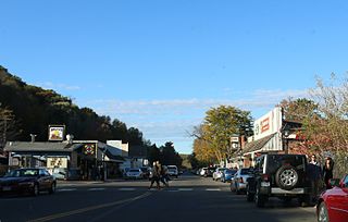
Taylors Falls is a city in Chisago County, Minnesota, United States, located at the junction of U.S. Highway 8 and Minnesota State Highway 95. The population was 1,055 at the 2020 census.
Pardeeville is a village in Columbia County, Wisconsin, United States. The population was 2,115 at the 2010 census. It is part of the Madison Metropolitan Statistical Area.
Prescott is a city in Pierce County, Wisconsin at the confluence of the St. Croix River and Mississippi River. The population was 4,333 at the 2020 census, making it the second-largest city in the county after River Falls, and the largest entirely within Pierce County.
Abbotsford is a city in Clark (mostly) and Marathon counties in the U.S. state of Wisconsin. The population was 2,275 at the 2020 census. Of this, 1,665 were in Clark County, and 610 were in Marathon County. Abbotsford is nicknamed "Wisconsin's First City" due to its alphabetical place on a list of Wisconsin cities.
Ellsworth is a village in and the county seat of Pierce County, Wisconsin, United States. The population was 3,348 at the 2020 census. The village is adjacent to the Town of Ellsworth and now incorporates the formerly separate district known as East Ellsworth. The municipality of Ellsworth and its surroundings are slowly becoming incorporated into the Twin Cities Metro Area.
St. Croix Falls is a town in Polk County, Wisconsin, United States. The population was 1,119 at the 2000 census. The City of St. Croix Falls is located within the town. The unincorporated community of Lamar is located in the town.
St. Croix Falls is a city in Polk County, Wisconsin, United States. The population was 2,208 at the 2020 census. The city is located within the Town of St. Croix Falls.