Bay City, Wisconsin

Last updated
Bay City, Wisconsin
Pierce County Wisconsin Incorporated and Unincorporated areas Bay City Highlighted.svg
Location of Bay City in Pierce County, Wisconsin.
Coordinates: 44°35′4″N92°27′10″W / 44.58444°N 92.45278°W / 44.58444; -92.45278 Coordinates: 44°35′4″N92°27′10″W / 44.58444°N 92.45278°W / 44.58444; -92.45278
Country Flag of the United States.svg  United States
State Flag of Wisconsin.svg  Wisconsin
County Pierce
Area
[1]
  Total0.61 sq mi (1.57 km2)
  Land0.59 sq mi (1.53 km2)
  Water0.01 sq mi (0.04 km2)
Elevation
[2]
692 ft (211 m)
Population
 (2010) [3]
  Total500
  Estimate 
(2019) [4]
494
  Density835.87/sq mi (322.71/km2)
Time zone UTC-6 (Central (CST))
  Summer (DST) UTC-5 (CDT)
Area codes 715 & 534
FIPS code 55-05325 [5]
GNIS feature ID1561318 [2]
Website http://www.baycitywi.org

Bay City is a village on the Mississippi River in Pierce County, Wisconsin, United States. The population was 500 at the 2010 census.

Contents

Geography

Bay City is located at 44°35′4″N92°27′10″W / 44.58444°N 92.45278°W / 44.58444; -92.45278 (44.584517, -92.452749). [6]

According to the United States Census Bureau, the village has a total area of 0.61 square miles (1.58 km2), of which 0.59 square miles (1.53 km2) is land and 0.02 square miles (0.05 km2) is water. [7]

Demographics

Historical population
CensusPop.
1910 252
1920 213−15.5%
1930 29036.2%
1940 2993.1%
1950 3269.0%
1960 3270.3%
1970 317−3.1%
1980 54371.3%
1990 5786.4%
2000 465−19.6%
2010 5007.5%
2019 (est.)494 [4] −1.2%
U.S. Decennial Census [8]

2010 census

As of the census [3] of 2010, there were 500 people, 201 households, and 128 families living in the village. The population density was 847.5 inhabitants per square mile (327.2/km2). There were 214 housing units at an average density of 362.7 per square mile (140.0/km2). The racial makeup of the village was 98.4% White, 0.8% African American, 0.2% Native American, 0.4% Asian, and 0.2% from two or more races. Hispanic or Latino of any race were 0.6% of the population.

There were 201 households, of which 35.3% had children under the age of 18 living with them, 45.3% were married couples living together, 10.0% had a female householder with no husband present, 8.5% had a male householder with no wife present, and 36.3% were non-families. 26.9% of all households were made up of individuals, and 6% had someone living alone who was 65 years of age or older. The average household size was 2.49 and the average family size was 3.00.

The median age in the village was 38.4 years. 26.6% of residents were under the age of 18; 5.6% were between the ages of 18 and 24; 28.4% were from 25 to 44; 25.8% were from 45 to 64; and 13.6% were 65 years of age or older. The gender makeup of the village was 50.6% male and 49.4% female.

2000 census

As of the census [5] of 2000, there were 465 people, 187 households, and 120 families living in the village. The population density was 904.1 inhabitants per square mile (349.1/km2). There were 193 housing units at an average density of 375.3 per square mile (144.9/km2). The racial makeup of the village was 99.14% White, and 0.86% from two or more races.

There were 187 households, out of which 29.9% had children under the age of 18 living with them, 50.3% were married couples living together, 7.0% had a female householder with no husband present, and 35.8% were non-families. 25.1% of all households were made up of individuals, and 10.2% had someone living alone who was 65 years of age or older. The average household size was 2.49 and the average family size was 2.94.

In the village, the population was spread out, with 23.4% under the age of 18, 7.5% from 18 to 24, 28.0% from 25 to 44, 28.2% from 45 to 64, and 12.9% who were 65 years of age or older. The median age was 40 years. For every 100 females, there were 114.3 males. For every 100 females age 18 and over, there were 114.5 males.

The median income for a household in the village was $47,679, and the median income for a family was $50,962. Males had a median income of $34,844 versus $25,500 for females. The per capita income for the village was $19,598. About 2.3% of families and 6.1% of the population were below the poverty line, including 4.4% of those under age 18 and 6.5% of those age 65 or over.

Related Research Articles

<span class="mw-page-title-main">ʻEleʻele</span> Census-designated place in Hawaii, United States

ʻEleʻele is a census-designated place (CDP) on the island of Kauaʻi in Kauaʻi County, Hawaiʻi, United States, with the ZIP code of 96705. Glass Beach, that is made of sea glass, is a local attraction. The population was 2,515 at the 2020 census, up from 2,040 at the 2000 census.

<span class="mw-page-title-main">Malvern, Iowa</span> City in Iowa, United States

Malvern is a city in Mills County, Iowa, United States. The population was 1,046 at the time of the 2020 census. The Wabash Trace—a railroad converted to a bicycle trail—passes through Malvern. The Mills County Fair is held here, although Glenwood is the county seat. Malvern is the largest town in the eastern half of the county.

<span class="mw-page-title-main">Langdon Place, Kentucky</span> City in Kentucky, United States

Langdon Place is a home rule-class city in Jefferson County, Kentucky, United States. The population was 936 as of the 2010 census.

<span class="mw-page-title-main">Glenmora, Louisiana</span> Town in Louisiana, United States

Glenmora is a town in Rapides Parish, Louisiana, United States. It is part of the Alexandria, Louisiana Metropolitan Statistical Area. The population was 1,342 at the 2010 census.

Otis is a town in Hancock County, Maine, United States. The population was 673 at the 2020 census.

<span class="mw-page-title-main">Algonquin, Maryland</span> Census-designated place in Maryland, United States

Algonquin is a census-designated place (CDP) in Dorchester County, Maryland, United States. The population was 1,241 at the 2010 census. The community was named for the Algonquin people, one of the Native American tribes in the East.

<span class="mw-page-title-main">West Line, Missouri</span> Village in Missouri, United States

West Line is a village in Cass County, Missouri. The population was 97 at the 2010 census. It is part of the Kansas City metropolitan area.

<span class="mw-page-title-main">Hanley Hills, Missouri</span> Village in Missouri, United States

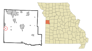
Hanley Hills is a village in St. Louis County, Missouri, United States. The population was 2,101 at the 2010 census.

<span class="mw-page-title-main">Addyston, Ohio</span> Village in Ohio, United States

Addyston is a village in Miami Township, Hamilton County, Ohio, United States, along the Ohio River. The population was 938 at the 2010 census.

<span class="mw-page-title-main">New Bloomington, Ohio</span> Village in Ohio, United States

New Bloomington is a village in Marion County, Ohio, United States. The population was 515 at the 2010 census. New Bloomington is served by Elgin Local School District.

<span class="mw-page-title-main">Markleysburg, Pennsylvania</span> Borough in Pennsylvania, United States

Markleysburg is a borough in Fayette County, Pennsylvania, United States. The population was 246 at the 2020 census. The borough is served by the Uniontown Area School District.

<span class="mw-page-title-main">Mount Sterling, Wisconsin</span> Village in Wisconsin, United States

Mount Sterling is a village in Crawford County, Wisconsin, United States. The population was 211 at the 2010 census.

<span class="mw-page-title-main">Blue River, Wisconsin</span> Village in Wisconsin, United States

Blue River is a village in Grant County, Wisconsin, United States. The population was 434 at the 2010 census.

<span class="mw-page-title-main">Tennyson, Wisconsin</span> Village in Wisconsin, United States

Tennyson is a village in Grant County, Wisconsin, United States, originally called Dutch Hollow. The population was 355 at the 2010 census.

<span class="mw-page-title-main">Cecil, Wisconsin</span> Village in Wisconsin, United States

Cecil is a village in Shawano County, Wisconsin, United States. The population was 570 at the 2010 census.

<span class="mw-page-title-main">Theresa, Wisconsin</span> Village in Wisconsin, United States

Theresa is a village in Dodge County, Wisconsin, United States. The population was 1,262 at the 2010 census. The village is within the Town of Theresa.

<span class="mw-page-title-main">Bloomington, Wisconsin</span> Village in Wisconsin, United States

Bloomington is a village in Grant County, Wisconsin, United States. The population was 735 as of the 2010 census. The village is located within the Town of Bloomington.

Casco is a town in Kewaunee County, Wisconsin, United States. The population was 1,165 at the 2010 census. The village of Casco, a separate municipality, is in the northwest part of the town, and the unincorporated communities of Clyde, Ryans Corner, Slovan, and Rio Creek are located in the town.

Plover is a town in Portage County, Wisconsin, United States. As of December 2020 the town reported on its website a population of 1,731.

<span class="mw-page-title-main">Dixfield (CDP), Maine</span> CDP in Maine, United States

Dixfield is a census-designated place (CDP) in the town of Dixfield in Oxford County, Maine, United States. The population was 1,137 at the 2000 census.

References

  1. "2019 U.S. Gazetteer Files". United States Census Bureau. Retrieved August 7, 2020.
  2. 1 2 "US Board on Geographic Names". United States Geological Survey. 2007-10-25. Retrieved 2008-01-31.
  3. 1 2 "U.S. Census website". United States Census Bureau . Retrieved 2012-11-18.
  4. 1 2 "Population and Housing Unit Estimates". United States Census Bureau. May 24, 2020. Retrieved May 27, 2020.
  5. 1 2 "U.S. Census website". United States Census Bureau . Retrieved 2008-01-31.
  6. "US Gazetteer files: 2010, 2000, and 1990". United States Census Bureau. 2011-02-12. Retrieved 2011-04-23.
  7. "US Gazetteer files 2010". United States Census Bureau. Archived from the original on 2012-01-25. Retrieved 2012-11-18.
  8. "Census of Population and Housing". Census.gov. Retrieved June 4, 2015.