River Falls, Wisconsin

Last updated

River Falls, Wisconsin
River Falls City Hall.jpg
City hall
Pierce County Wisconsin Incorporated and Unincorporated areas River Falls Highlighted.svg
Location of River Falls in Pierce County
and St. Croix County, Wisconsin.
USA Wisconsin relief location map.svg
Red pog.svg
River Falls
Usa edcp relief location map.png
Red pog.svg
River Falls
Coordinates: 44°51′31″N92°37′30″W / 44.85861°N 92.62500°W / 44.85861; -92.62500
CountryFlag of the United States.svg  United States
State Flag of Wisconsin.svg  Wisconsin
County Pierce and St. Croix
Incorporated 1885
Government
  TypeMayor – Council
  MayorDan Toland
Area
[1]
  Total
7.27 sq mi (18.83 km2)
  Land7.19 sq mi (18.61 km2)
  Water0.08 sq mi (0.21 km2)
Population
 (2020)
  Total
16,182
  Density2,230.00/sq mi (861.05/km2)
Time zone UTC−6 (Central (CST))
  Summer (DST) UTC−5 (CDT)
Area code(s) 715 & 534
FIPS code 55-68275
Website http://www.rfcity.org
South Hall, on the University of Wisconsin-River Falls campus, is on the National Register of Historic Places. 2009-0620-UW-RiverFalls-SouthHall.jpg
South Hall, on the University of Wisconsin-River Falls campus, is on the National Register of Historic Places.

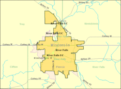
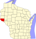
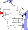
River Falls is a city in Pierce and St. Croix counties in the U.S. state of Wisconsin. It is located mostly within the town of River Falls, and adjacent to the town of Kinnickinnic in St. Croix County. River Falls is the most populous city in Pierce County. The population was 16,182 at the 2020 census, with 12,546 residing in Pierce County and 3,636 in St. Croix County. It is part of the Minneapolis–St. Paul metropolitan area and located approximately 30 miles (48 km) east of the center of that region. [2]

Contents

River Falls is the home of the University of Wisconsin–River Falls.

History

The city's first settlers were Joel Foster and his indentured servant, Dick, in 1848. [3] The village was started as Kinnickinnic in 1854 by brothers Nathaniel N. and Oliver S. Powell, who were from St. Lawrence County, New York. At the time, the town and village were also known as Greenwood, but this was changed, as another Greenwood, Wisconsin already existed. [4] The present name comes from the Kinnickinnic River rapids. [5]

On June 23, 1893, a lightning bolt hit the center circus pole at a Ringling Brothers circus performance in River Falls, injuring multiple audience members and performers and killing seven. [6]

Geography

According to the United States Census Bureau, the city has a total area of 6.60 square miles (17.09 km2), of which 6.52 square miles (16.89 km2) is land and 0.08 square miles (0.21 km2) is water. [7]

River Falls lies on the banks of the Kinnickinnic River, a class one trout stream. The South Fork of the Kinnickinnic River runs through the city, dividing the University of Wisconsin-River Falls campus into two sections.

River Falls is along Wisconsin Highways 29, 35, and 65. Other routes include Main Street, Cascade Avenue, and Division Street / County Road M.

River Falls, Wisconsin.jpg

Climate

Climate data for River Falls, Wisconsin (1991–2020 normals, extremes 1918–present)
MonthJanFebMarAprMayJunJulAugSepOctNovDecYear
Record high °F (°C)57
(14)
63
(17)
81
(27)
92
(33)
96
(36)
106
(41)
109
(43)
103
(39)
103
(39)
90
(32)
78
(26)
66
(19)
109
(43)
Mean daily maximum °F (°C)22.0
(−5.6)
27.1
(−2.7)
40.1
(4.5)
55.2
(12.9)
67.6
(19.8)
77.1
(25.1)
81.5
(27.5)
79.1
(26.2)
71.4
(21.9)
57.2
(14.0)
40.8
(4.9)
27.4
(−2.6)
53.9
(12.2)
Daily mean °F (°C)13.2
(−10.4)
17.3
(−8.2)
29.9
(−1.2)
43.4
(6.3)
55.5
(13.1)
65.4
(18.6)
69.9
(21.1)
67.7
(19.8)
60.2
(15.7)
46.7
(8.2)
32.3
(0.2)
19.6
(−6.9)
43.4
(6.3)
Mean daily minimum °F (°C)4.3
(−15.4)
7.6
(−13.6)
19.6
(−6.9)
31.6
(−0.2)
43.4
(6.3)
53.8
(12.1)
58.3
(14.6)
56.3
(13.5)
49.0
(9.4)
36.2
(2.3)
23.8
(−4.6)
11.9
(−11.2)
33.0
(0.6)
Record low °F (°C)−42
(−41)
−47
(−44)
−38
(−39)
−8
(−22)
19
(−7)
30
(−1)
37
(3)
32
(0)
22
(−6)
5
(−15)
−19
(−28)
−36
(−38)
−47
(−44)
Average precipitation inches (mm)0.90
(23)
0.85
(22)
1.67
(42)
3.08
(78)
4.29
(109)
5.03
(128)
4.39
(112)
4.68
(119)
3.56
(90)
2.95
(75)
1.58
(40)
1.08
(27)
34.06
(865)
Source: NOAA [8] [9]

Demographics

Kinnickinnic River, downtown River Falls. 2009-0620-RiverFalls-river.jpg
Kinnickinnic River, downtown River Falls.
Outline map of River Falls River-falls-wi.gif
Outline map of River Falls
Historical population
CensusPop.Note
1860 272
1870 741172.4%
1880 1,499102.3%
1890 1,78318.9%
1900 2,00812.6%
1910 1,991−0.8%
1920 2,27314.2%
1930 2,3634.0%
1940 2,80618.7%
1950 3,87738.2%
1960 4,85725.3%
1970 7,23849.0%
1980 9,01924.6%
1990 10,61017.6%
2000 12,56018.4%
2010 15,00019.4%
2020 16,1827.9%
U.S. Decennial Census [10]

2000 census

At the 2000 census there were 12,560 people, 4,269 households, and 2,335 families living in the city. The population density was 2,524.0 inhabitants per square mile (974.5/km2). There were 4,346 housing units at an average density of 873.2 per square mile (337.1/km2). The racial makeup of the city was 96.57% White, 0.53% Black or African American, 0.36% Native American, 1.02% Asian, 0.09% Pacific Islander, 0.32% from other races, and 1.12% from two or more races. Hispanic or Latino of any race were 0.95%. [11]

Of the 4,269 households 29.1% had children under the age of 18 living with them, 42.7% were married couples living together, 9.1% had a female householder with no husband present, and 45.3% were non-families. 27.7% of households were one person and 9.1% were one person aged 65 or older. The average household size was 2.44 and the average family size was 2.98.

The age distribution was 17.9% under the age of 18, 35.1% from 18 to 24, 23.8% from 25 to 44, 14.6% from 45 to 64, and 8.6% 65 or older. The median age was 24 years. For every 100 females, there were 83.5 males. For every 100 females age 18 and over, there were 80.1 males.

The median household income was $41,184 and the median family income was $60,253. Males had a median income of $36,275 versus $27,345 for females. The per capita income for the city was $17,667. About 4.4% of families and 14.9% of the population were below the poverty line, including 6.6% of those under age 18 and 11.1% of those age 65 or over.

2010 census

At the 2010 census there were 15,000 people, 5,150 households, and 2,812 families living in the city. The population density was 2,300.6 inhabitants per square mile (888.3/km2). There were 5,449 housing units at an average density of 835.7 per square mile (322.7/km2). The racial makeup of the city was 94.8% White, 1.2% African American, 0.4% Native American, 1.5% Asian, 0.5% from other races, and 1.6% from two or more races. Hispanic or Latino of any race were 1.8%. [12]

Of the 5,150 households 28.2% had children under the age of 18 living with them, 40.6% were married couples living together, 9.9% had a female householder with no husband present, 4.1% had a male householder with no wife present, and 45.4% were non-families. 27.1% of households were one person and 8.4% were one person aged 65 or older. The average household size was 2.42 and the average family size was 2.89.

The median age was 24.2 years. 17.2% of residents were under the age of 18; 34.5% were between the ages of 18 and 24; 23% were from 25 to 44; 17% were from 45 to 64; and 8.2% were 65 or older. The gender makeup of the city was 46.8% male and 53.2% female.

2020 census

At the 2020 census, there were 16,182 people and 5,521 households. The racial makeup of the city was 92.6% White, 0.7% African American, 0.3% Native American, 1.6% Asian, 0.5% from other races, and 4.1% from two or more races. Hispanic or Latino of any race were 2.3%. Native Hawaiian was 0.1%. [12]

Education

School District of River Falls operates public schools. River Falls High School is the district's public high school. Meyer Middle School acts as the district's middle school. There are also 5 public elementary schools in the school district. [13]

CVTC in River Falls Chippewa Valley Technical College in River Falls, Wisconsin.jpg
CVTC in River Falls

River Falls is home to the University of Wisconsin-River Falls and a branch of the Chippewa Valley Technical College.

Recreation

The Kinnickinnic River, which flows through the heart of the city and its downtown business district, is a popular recreational attraction in River Falls for fly fishers and kayakers.

On the bluffs of the Kinnickinnic River is Glen Park, a 41-acre park established in 1898. The park has playgrounds, a swimming pool, soccer fields, a softball diamond, basketball courts, horseshoe pits, a gazebo, and several miles of walking trails. [14] The Glen Park Pool was built in 1937 and renovated for its 75th anniversary in 2012. [15] Glen Park's Swinging Bridge offers a view of the South Fork rapids as it enters the Kinnickinnic River. The bridge, a replica of one designed by the Minneapolis Bridge Company and constructed in 1925, is a suspension bridge that spans the South Fork Rapids at the site of the former Cascade Mill and Dam. Below the bridge are fishing, swimming, and picnic spots. [16]

Hoffman Park, located northeast of downtown River Falls, is a 53-acre (21 ha) facility that contains baseball fields, a nine-hole disc golf course, a campsite, a skate park, volleyball courts, and the Tri-Angels Playground. [17] The playground was named after Amara, Sophie, and Cecilia Schaffhausen, who were murdered by their father, Aaron Schaffhausen. The playground, accessible to handicapped children and built with designs referring to the three girls, opened in 2015. [18] It was constructed at a cost of $550,000 by volunteers. [19]

Another attraction is The Falls Theater, a movie theater.

Notable people

Related Research Articles

<span class="mw-page-title-main">St. Croix County, Wisconsin</span> County in Wisconsin, United States

St. Croix County is a county in the U.S. state of Wisconsin. As of the 2020 census, the population was 93,536. Its county seat is Hudson. The county was created in 1840 and organized in 1849. St. Croix County is part of the Minneapolis-St. Paul-Bloomington, MN-WI Metropolitan Statistical Area. Between 2000 and 2010, it was Wisconsin's fastest-growing county.

<span class="mw-page-title-main">Rock Falls, Illinois</span> City in Whiteside County, Illinois, US

Rock Falls is a city in Whiteside County, Illinois, United States. The recorded population was 8,606 at the 2020 census, down 7.12% from 9,266 in 2010. The city is located on the Rock River, directly opposite its twin city of Sterling.

<span class="mw-page-title-main">Taylors Falls, Minnesota</span> City in Minnesota, United States

Taylors Falls is a city in Chisago County, Minnesota, United States, located at the junction of U.S. Highway 8 and Minnesota State Highway 95. The population was 1,055 at the 2020 census.

<span class="mw-page-title-main">Hokah, Minnesota</span> City in Minnesota, United States

Hokah is a city in Houston County, Minnesota, United States. The population was 580 at the 2010 census. Hokah is located near the confluence of the Root and Mississippi rivers, opposite La Crosse, Wisconsin.

<span class="mw-page-title-main">Stillwater, Minnesota</span> City in Minnesota, United States

Stillwater is a city in the U.S. state of Minnesota and the county seat of Washington County. It is in the Minneapolis–Saint Paul metropolitan area, on the west bank of the St. Croix River, across from Houlton, Wisconsin. Stillwater's population was 19,394 at the 2020 census. Stillwater is often called "the birthplace of Minnesota" due to its role in the establishment of the state.

<span class="mw-page-title-main">Newton Falls, Ohio</span> Village in Ohio, United States

Newton Falls is a village in southwestern Trumbull County, Ohio, United States. The population was 4,557 at the 2020 census. It is part of the Youngstown–Warren metropolitan area. The city takes its name from the two sets of waterfalls within the village, each on different branches of the Mahoning River. The city is known for its notable ZIP code (44444) and for its covered bridge, which is the second oldest in the state of Ohio.

<span class="mw-page-title-main">New Haven, Vermont</span> Town in Vermont, United States

New Haven is a town in Addison County, Vermont, United States. The population was 1,683 at the 2020 census. In addition to the town center, New Haven contains the communities of Belden, Brooksville, New Haven Junction and New Haven Mills.

<span class="mw-page-title-main">Chippewa Falls, Wisconsin</span> City in Wisconsin, United States

Chippewa Falls is a city located on the Chippewa River in Chippewa County, Wisconsin, United States. The population was 14,731 in the 2020 census. Incorporated as a city in 1869, it is the county seat of Chippewa County. The city's name originated from its location on the Chippewa River, which is named after the Ojibwe. It is a principal city of the Eau Claire–Chippewa Falls metropolitan area.

<span class="mw-page-title-main">Prescott, Wisconsin</span> City in Wisconsin, United States

Prescott is a city in Pierce County, Wisconsin, United States, at the confluence of the St. Croix River and Mississippi River. Prescott is located at the edge of the Minneapolis–St. Paul metropolitan area. The population was 4,333 at the 2020 census, making it the second-largest city in the county after River Falls, and the largest entirely within Pierce County.

<span class="mw-page-title-main">Park Falls, Wisconsin</span> City in Wisconsin, United States

Park Falls is a city in Price County, Wisconsin, United States. The population was 2,410 at the 2020 census, down from 2,462 at 2010. Located in the woods of north central Wisconsin, primarily the Chequamegon National Forest, Park Falls is a small community divided by the North Fork of the Flambeau River, a popular destination for fishing, canoeing and whitewater rafting.

<span class="mw-page-title-main">Kinnickinnic, Wisconsin</span> Town in Wisconsin, United States

Kinnickinnic is a town in St. Croix County, Wisconsin, United States. The population was 1,400 at the 2000 census.

<span class="mw-page-title-main">Hastings, Minnesota</span> City in Minnesota, United States

Hastings is a city mostly in Dakota County, Minnesota, of which it is the county seat, with a portion in Washington County, Minnesota, United States. It is near the confluence of the Mississippi, Vermillion, and St. Croix Rivers. The population was 22,154 at the 2020 census. It is named for the first elected governor of Minnesota, Henry Hastings Sibley.

<span class="mw-page-title-main">Green Lake, Wisconsin</span> City in Wisconsin, United States

Green Lake is a city in and county seat of Green Lake County, Wisconsin, United States. The city had a population of 1,001 in the 2020 census. It is located on the north side of Green Lake. The Town of Green Lake is located on the south side of Big Green Lake, opposite the city.

<span class="mw-page-title-main">Merrill, Wisconsin</span> City in Wisconsin, United States

Merrill is a city in and the county seat of Lincoln County, Wisconsin, United States. It is located to the south of and adjacent to the Town of Merrill. The population was 9,347, according to the 2020 census. Merrill is part of the United States Census Bureau's Merrill MSA, which includes all of Lincoln County. Together with the Wausau MSA, which includes all of Marathon County, it forms the Wausau-Merrill CSA.

<span class="mw-page-title-main">St. Croix Falls (town), Wisconsin</span> Town in Wisconsin, United States

St. Croix Falls is a town in Polk County, Wisconsin, United States. The population was 1,119 at the 2000 census. The City of St. Croix Falls is located within the town. The unincorporated community of Lamar is located in the town.

<span class="mw-page-title-main">St. Croix Falls, Wisconsin</span> City in Wisconsin, United States

St. Croix Falls is a city in Polk County, Wisconsin, United States. The population was 2,208 at the 2020 census. The city is located within the Town of St. Croix Falls along the St. Croix River, from which it takes its name. U.S. Route 8, Wisconsin Highway 35, and Wisconsin Highway 87 are three of the main arterial routes in the city.

<span class="mw-page-title-main">Sheboygan Falls, Wisconsin</span> City in United States, Town of Rochester

Sheboygan Falls is a city in Sheboygan County, Wisconsin, United States, along the Sheboygan River. The population was 8,210 at the 2020 census. It is part of the Sheboygan metropolitan area.

<span class="mw-page-title-main">Hudson, Wisconsin</span> City in Wisconsin, United States

Hudson is a city in and the county seat of St. Croix County, Wisconsin, United States. As of the 2020 census, its population was 14,755. It is part of the Minneapolis–St. Paul metropolitan area.

<span class="mw-page-title-main">Berlin, Wisconsin</span> City in Wisconsin, United States

Berlin is a city in Green Lake and Waushara counties in the U.S. state of Wisconsin. The population was 5,571 at the 2020 census. Of this, 5,435 were in Green Lake County, and only 89 were in Waushara County. The city is located mostly within the Town of Berlin in Green Lake County, with a small portion extending into the Town of Aurora in Waushara County.

<span class="mw-page-title-main">Black River Falls, Wisconsin</span> City in Wisconsin, United States

Black River Falls is a city in and the county seat of Jackson County, Wisconsin, United States. The population was 3,523 at the 2020 census. It is home to the administrative center of the Ho-Chunk Nation.

References

  1. "2019 U.S. Gazetteer Files". United States Census Bureau. Retrieved August 7, 2020.
  2. "Maps and Lodging." University of Wisconsin-River Falls. Retrieved on January 24, 2017.
  3. River Falls Wisconsin. Piercecountywi.com. Retrieved 2012-07-07.
  4. Easton, August B. History of Saint Croix Valley, p. 485.
  5. Chicago and North Western Railway Company (1908). A History of the Origin of the Place Names Connected with the Chicago & North Western and Chicago, St. Paul, Minneapolis & Omaha Railways. p. 189.
  6. "Circus Horror at River Falls, Seven Persons Were Killed". The Sun (Spring Valley, Minnesota), June 23, 1893, p. 1. St. Croix Valley Genealogical Society.
  7. "US Gazetteer files 2010". United States Census Bureau. Archived from the original on January 25, 2012. Retrieved November 18, 2012.
  8. "NOWData - NOAA Online Weather Data". National Oceanic and Atmospheric Administration. Retrieved March 28, 2024.
  9. "Summary of Monthly Normals 1991-2020". National Oceanic and Atmospheric Administration. Retrieved March 28, 2024.
  10. "Census of Population and Housing". Census.gov. Retrieved June 4, 2015.
  11. "U.S. Census website". United States Census Bureau . Retrieved January 31, 2008.
  12. 1 2 "U.S. Census website". United States Census Bureau . Retrieved November 18, 2012.
  13. "School District of River Falls - Schools Home".
  14. "Visit Planning - Entertainment & Recreation". River Falls Chamber of Commerce. Archived from the original on October 29, 2013. Retrieved October 23, 2013.
  15. "Hospital supports historic park pool". River Falls Journal. June 12, 2012. Archived from the original on October 29, 2013. Retrieved October 23, 2013.
  16. Smith, Margaret. "River Falls, Wisconsin - The Swinging Bridge at Glen Park". Heritage Initiative. Retrieved October 23, 2013.
  17. "Hoffman Park". River Falls. Retrieved January 24, 2017.
  18. Rupnow, Chuck (August 5, 2015). "Mom gets her first look at playground honoring her three slain daughters". Leader-Telegram . Retrieved January 23, 2017.
  19. Slavik, Rachel (June 27, 2015). "Volunteers Build Memorial Playground For River Falls Sisters". WCCO-TV (CBS Minnesota). Retrieved January 24, 2017.