Hammond, Wisconsin

Last updated

Hammond, Wisconsin
Nickname: 
Heart of St. Croix County
St. Croix County Wisconsin Incorporated and Unincorporated areas Hammond Highlighted.svg
Location of Hammond in St. Croix County, Wisconsin.
Coordinates: 44°59′59″N92°25′34″W / 44.99972°N 92.42611°W / 44.99972; -92.42611
Country Flag of the United States.svg  United States
State Flag of Wisconsin.svg  Wisconsin
County St. Croix
Government
  TypeVillage Board
Area
[1]
  Total2.16 sq mi (5.59 km2)
  Land2.16 sq mi (5.59 km2)
  Water0.00 sq mi (0.00 km2)
Elevation
[2]
1,089 ft (332 m)
Population
 (2010) [3]
  Total1,922
  Estimate 
(2019) [4]
1,886
  Density873.15/sq mi (337.20/km2)
Time zone UTC-6 (Central (CST))
  Summer (DST) UTC-5 (CDT)
Area code(s) 715 & 534
FIPS code 55-32350 [5]
GNIS feature ID1581640 [2]
Website www.hammondwi.org

Hammond is a village in St. Croix County, Wisconsin, United States. The population was 1,922 at the 2010 census. The village is located within the Town of Hammond. Hammond was home to the Running of the Llamas. [6]

Contents

History

Hammond was named in 1856 for R. B. Hammond, an original owner of the town site. [7] A post office called Hammond has been in operation since 1858. [8]

Geography

Hammond is located at 44°58′32″N92°26′7″W / 44.97556°N 92.43528°W / 44.97556; -92.43528 (44.975598, -92.435452). [9]

According to the United States Census Bureau, the village has a total area of 2.15 square miles (5.57 km2), all of it land. [10]

Demographics

Historical population
CensusPop.Note
1880 361
1890 3887.5%
1900 4044.1%
1910 4081.0%
1920 368−9.8%
1930 3957.3%
1940 46718.2%
1950 55418.6%
1960 64516.4%
1970 76819.1%
1980 99129.0%
1990 1,09710.7%
2000 1,1535.1%
2010 1,92266.7%
2019 (est.)1,886 [4] −1.9%
U.S. Decennial Census [11]

2010 census

As of the census [3] of 2010, there were 1,922 people, 715 households, and 499 families living in the village. The population density was 894.0 inhabitants per square mile (345.2/km2). There were 773 housing units at an average density of 359.5 per square mile (138.8/km2). The racial makeup of the village was 96.0% White, 0.5% African American, 0.4% Native American, 0.7% Asian, 0.1% Pacific Islander, 0.6% from other races, and 1.8% from two or more races. Hispanic or Latino of any race were 2.9% of the population.

There were 715 households, of which 40.7% had children under the age of 18 living with them, 54.8% were married couples living together, 9.2% had a female householder with no husband present, 5.7% had a male householder with no wife present, and 30.2% were non-families. 23.9% of all households were made up of individuals, and 7.4% had someone living alone who was 65 years of age or older. The average household size was 2.62 and the average family size was 3.08.

The median age in the village was 33.1 years. 29.3% of residents were under the age of 18; 6.7% were between the ages of 18 and 24; 32.7% were from 25 to 44; 22.3% were from 45 to 64; and 9.1% were 65 years of age or older. The gender makeup of the village was 49.7% male and 50.3% female.

2000 census

As of the census [5] of 2000, there were 1,153 people, 433 households, and 313 families living in the village. The population density was 840.2 inhabitants per square mile (324.4/km2). There were 438 housing units at an average density of 319.2 per square mile (123.2/km2). The racial makeup of the village was 98.79% White, 0.09% Black or African American, 0.17% Asian, and 0.95% from two or more races. 0.26% of the population were Hispanic or Latino of any race.

There were 433 households, out of which 39.7% had children under the age of 18 living with them, 56.4% were married couples living together, 11.8% had a female householder with no husband present, and 27.7% were non-families. 20.6% of all households were made up of individuals, and 7.6% had someone living alone who was 65 years of age or older. The average household size was 2.55 and the average family size was 2.95.

In the village, the population was spread out, with 26.5% under the age of 18, 9.5% from 18 to 24, 32.1% from 25 to 44, 18.3% from 45 to 64, and 13.5% who were 65 years of age or older. The median age was 34 years. For every 100 females, there were 88.4 males. For every 100 females age 18 and over, there were 88.6 males.

The median income for a household in the village was $45,789, and the median income for a family was $54,722. Males had a median income of $37,337 versus $27,031 for females. The per capita income for the village was $19,002. About 2.5% of families and 3.5% of the population were below the poverty line, including 3.1% of those under age 18 and 4.6% of those age 65 or over.

Related Research Articles

<span class="mw-page-title-main">Dover, Illinois</span> Village in Illinois, United States

Dover is a village in Bureau County, Illinois, United States. The population was 135 at the 2020 census. It is part of the Ottawa Micropolitan Statistical Area.

<span class="mw-page-title-main">Atlanta, Kansas</span> City in Cowley County, Kansas

Atlanta is a city in Cowley County, Kansas, United States. As of the 2020 census, the population of the city was 168.

<span class="mw-page-title-main">Grosse Tête, Louisiana</span> Village in Louisiana, United States

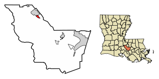
Grosse Tête is a village in Iberville Parish, Louisiana, United States. The population was 647 at the 2010 census, and 731 at the 2019 American Community Survey. The village name is French for "Big Head". Grosse Tête is part of the Baton Rouge metropolitan statistical area.

<span class="mw-page-title-main">Utica, Minnesota</span> City in Minnesota, United States

Utica is a city in Winona County, Minnesota, United States. The population was 266 at the 2020 census.

<span class="mw-page-title-main">Moore, Montana</span> Town in Montana, United States

Moore is a town in Fergus County, Montana, United States. The population was 194 at the 2020 census.

<span class="mw-page-title-main">Midvale, Ohio</span> Village in Ohio, United States

Midvale is a village in Tuscarawas County, Ohio, United States. The population was 754 at the 2010 census.

<span class="mw-page-title-main">Alvordton, Ohio</span> CDP in Ohio, United States

Alvordton is a census-designated place in central Mill Creek Township, Williams County, Ohio, United States. The population was 305 at the 2000 census, at which time it was a village. In 2010, the U.S. Census Bureau listed Alvordton as a census-designated place.

<span class="mw-page-title-main">South New Castle, Pennsylvania</span> Borough in Pennsylvania, United States

South New Castle is a borough in Lawrence County, Pennsylvania, United States. The population was 649 at the 2020 census. It is primarily a residential community which lies south of the city of New Castle, and is part of the New Castle micropolitan area.

<span class="mw-page-title-main">Nespelem, Washington</span> Town in Washington, United States

Nespelem is a town in Okanogan County, Washington, United States. The population was 236 at the 2010 census. The town is located on the Colville Indian Reservation. The name Nespelem is derived from a local Native American term meaning "large flat meadow".

<span class="mw-page-title-main">Downing, Wisconsin</span> Village in Wisconsin, United States

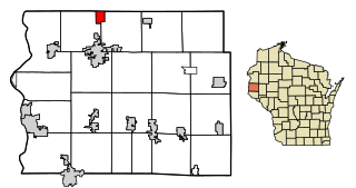
Downing is a village in Dunn County, Wisconsin, United States. Bordering St. Croix County to the west, the village is otherwise surrounded by the Town of Tiffany. The population was 234 at the 2020 census.

<span class="mw-page-title-main">Deer Park, Wisconsin</span> Village in Wisconsin, United States

Deer Park is a village in St. Croix County, Wisconsin, United States. The population was 216 at the 2010 census.

<span class="mw-page-title-main">Roberts, Wisconsin</span> Village in Wisconsin, United States

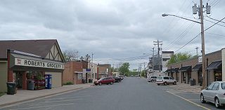
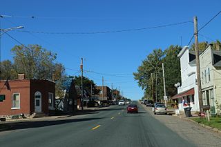
Roberts is a village in St. Croix County, Wisconsin, United States. The population was 1,651 at the 2010 census. The village is surrounded by the town of Warren.
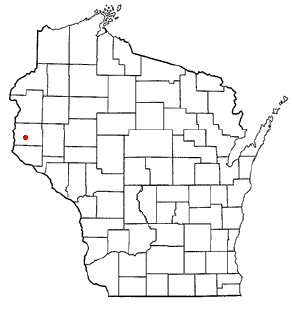
<span class="mw-page-title-main">Wilson, St. Croix County, Wisconsin</span> Village in Wisconsin, United States

Wilson is a village in St. Croix County, Wisconsin, United States. The population was 184 at the 2010 census.

<span class="mw-page-title-main">Richford, Wisconsin</span> Town in Wisconsin, United States

Richford is a town in Waushara County, Wisconsin, United States. The population was 588 at the 2000 census.

<span class="mw-page-title-main">Spring Valley, Wisconsin</span> Village in Wisconsin, United States

Spring Valley is a village in Pierce and St. Croix counties in Wisconsin, United States. The population was 1,401 at the 2020 census. Of those, 1,390 were in Pierce County and 11 in St. Croix County. The village is mostly within the Town of Spring Lake in Pierce County. Small parts also lie in the Town of Gilman, also in Pierce County, and the Town of Cady in St. Croix County.

Hammond is a village in St. Lawrence County, New York, United States. The population was 280 at the 2010 census. The village is named after an early landowner.

Mason is a town in Bayfield County, Wisconsin, United States. The population was 315 at the 2010 census. The Village of Mason is located within the town. The unincorporated community of Sutherland is located partially in the town.

<span class="mw-page-title-main">Osceola, Wisconsin</span> Village in Wisconsin, United States

Osceola is a village in Polk County, Wisconsin, United States. The population was 2,765 at the 2020 census. Located mostly within the Town of Osceola, the village sits on the border with Minnesota, separated by the St. Croix River. It is along Wisconsin Highway 35.

Hammond is a town in St. Croix County, Wisconsin, United States. The population was 947 at the 2000 census. The Village of Hammond is located within the town.

<span class="mw-page-title-main">Star Prairie, Wisconsin</span> Village in Wisconsin, United States

Star Prairie is a village in St. Croix County in the U.S. state of Wisconsin. The population was 561 at the 2010 census. The village is located along the Apple River on the boundary between the Town of Star Prairie and the Town of Stanton.

References

  1. "2019 U.S. Gazetteer Files". United States Census Bureau. Retrieved August 7, 2020.
  2. 1 2 "US Board on Geographic Names". United States Geological Survey. October 25, 2007. Retrieved January 31, 2008.
  3. 1 2 "U.S. Census website". United States Census Bureau . Retrieved November 18, 2012.
  4. 1 2 "Population and Housing Unit Estimates". United States Census Bureau. May 24, 2020. Retrieved May 27, 2020.
  5. 1 2 "U.S. Census website". United States Census Bureau . Retrieved January 31, 2008.
  6. Running of the Llamas
  7. Chicago and North Western Railway Company (1908). A History of the Origin of the Place Names Connected with the Chicago & North Western and Chicago, St. Paul, Minneapolis & Omaha Railways. p. 177.
  8. "Saint Croix County". Jim Forte Postal History. Retrieved April 4, 2015.
  9. "US Gazetteer files: 2010, 2000, and 1990". United States Census Bureau. February 12, 2011. Retrieved April 23, 2011.
  10. "US Gazetteer files 2010". United States Census Bureau . Retrieved November 18, 2012.
  11. "Census of Population and Housing". Census.gov. Retrieved June 4, 2015.