
St. Croix County is a county in the U.S. state of Wisconsin. As of the 2020 census, the population was 93,536. Its county seat is Hudson. The county was created in 1840 and organized in 1849. St. Croix County is part of the Minneapolis-St. Paul-Bloomington, MN-WI Metropolitan Statistical Area. Between 2000 and 2010, it was the fastest-growing county in Wisconsin.
Elmhurst is an unincorporated community in Langlade County, Wisconsin, United States. It is in the town of Rolling at latitude 45°3'30" North, longitude 89°11'3" West. The community is located near the headwaters of the Middle Branch Embarrass River, approximately 1½ miles west of the junction of WIS 47, WIS 52 and U.S. Highway 45 in the Town of Rolling. A track of the Chicago and North Western Railway runs along the west side of the community. Elmhurst is located at 1,476 feet (450 m) above sea level.

Manitowish is an unincorporated community located within the town of Mercer, Iron County, Wisconsin, United States. It is located at the junction of U.S. Route 51, Wisconsin Highway 47 and Wisconsin Highway 182.

Forest Junction is an unincorporated census-designated place in the town of Brillion, Calumet County, Wisconsin, United States. As of the 2010 census, its population was 616.

The River Subdivision or River Sub is a railway line along the Mississippi River that runs approximately 124 miles (200 km) from Saint Paul, Minnesota south to La Crescent. U.S. Highway 61 closely parallels the route between La Crescent and Red Wing. The line is operated by the Canadian Pacific Railway through its primary United States subsidiary, the Soo Line Railroad. BNSF Railway operates a complementary St. Croix Subdivision which traces the eastern side of the river in Minnesota and Wisconsin. The two routes share some track between Saint Paul and St. Croix Junction, near Hastings.
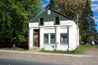
Emerald is a census-designated place in St. Croix County, Wisconsin, United States. Emerald is located in the towns of Emerald and Glenwood, 4.5 miles (7.2 km) west-northwest of Glenwood City. As of the 2010 census, its population was 161.

Marshland is an unincorporated community located in the town of Buffalo, in Buffalo County, Wisconsin, United States. Marshland is located on Wisconsin Highway 35 and Wisconsin Highway 54 8.5 miles (13.7 km) east-southeast of Fountain City.

Minnesota Junction is an unincorporated community located, in the town of Oak Grove, in Dodge County, Wisconsin, United States. Minnesota Junction is located on Wisconsin Highway 26. It is located at latitude 43.452 and longitude -88.697 at 925 feet above mean sea level.
Boardman is an unincorporated community in St. Croix County, Wisconsin located just southwest of New Richmond on County Road A, in the town of Richmond.
Split Rock is an unincorporated community located in the town of Fairbanks, Shawano County, Wisconsin, United States. Split Rock is located on County Highway SS near its junction with U.S. Route 45, 3 miles (4.8 km) southeast of Tigerton.
Whitcomb is an unincorporated community located in the town of Wittenberg, Shawano County, Wisconsin, United States. Whitcomb is located on Wisconsin Highway 153 near its junction with U.S. Route 45, 4 miles (6.4 km) southeast of the village of Wittenberg.

Valley Junction is an unincorporated community located in the Town of Byron in Monroe County, Wisconsin, United States. It is located at the intersection of Wisconsin Highway 173, Monroe County Trunk Highway G, and Monroe County Highway N.
Hersey is an unincorporated community located in the town of Springfield, St. Croix County, Wisconsin, United States. Hersey is located along the Union Pacific Railroad 2 miles (3.2 km) north-northwest of Wilson.
Woodhull is an unincorporated community located in the town of Lamartine, Fond du Lac County, Wisconsin, United States.
Stanton is an unincorporated community located in the town of Stanton, St. Croix County, Wisconsin, United States.
Ashland Junction is an unincorporated community located in the town of Eileen, Bayfield County, Wisconsin, United States.

Medary (also Winona Junction) is an unincorporated community located in the town of Medary, La Crosse County, Wisconsin, United States. The Great River State Trail has its trailhead located here.
Cobban is an unincorporated community located in the town of Arthur, Chippewa County, Wisconsin, United States. Cobban is located on the east bank of the Chippewa River at the junction of County Highways K and TT, 5.2 miles (8.4 km) south-southwest of Cornell.
Glover is an unincorporated community in the town of Troy, St. Croix County, Wisconsin, United States.
Wildwood is an unincorporated community in the town of Eau Galle, St. Croix, Wisconsin, United States.


