Roberts, Wisconsin

Last updated

Roberts, Wisconsin
Roberts, Wisconsin 1.jpg
St. Croix County Wisconsin Incorporated and Unincorporated areas Roberts Highlighted.svg
Location of Roberts
in St. Croix County, Wisconsin
USA Wisconsin location map.svg
Red pog.svg
Roberts
Location within the state of Wisconsin
Usa edcp location map.svg
Red pog.svg
Roberts
Location within the United States
North America laea location map.svg
Red pog.svg
Roberts
Roberts (North America)
Coordinates: 44°59′2″N92°33′14″W / 44.98389°N 92.55389°W / 44.98389; -92.55389
Country Flag of the United States.svg  United States
State Flag of Wisconsin.svg  Wisconsin
County St. Croix
Area
[1]
  Total2.59 sq mi (6.70 km2)
  Land2.59 sq mi (6.70 km2)
  Water0.00 sq mi (0.00 km2)
Elevation
[2]
1,033 ft (315 m)
Population
 (2010) [3]
  Total1,651
  Estimate 
(2019) [4]
1,889
  Density730.47/sq mi (282.07/km2)
Time zone UTC-6 (Central (CST))
  Summer (DST) UTC-5 (CDT)
Area code(s) 715 & 534
FIPS code 55-68475 [5]
GNIS feature ID1581705 [2]
Website www.robertswisconsin.com

Roberts is a village in St. Croix County, Wisconsin, United States. The population was 1,651 at the 2010 census. The village is surrounded by the town of Warren.

Contents

History

Roberts was named in 1873 for John Bannister Gibson Roberts, the chief engineer for the West Wisconsin Railroad. [6] [7] A post office called Roberts has been in operation since 1884. [8]

Geography

According to the United States Census Bureau, the village has a total area of 2.26 square miles (5.85 km2), all of it land. [9]

Roberts is located at 44°59′2″N92°33′14″W / 44.98389°N 92.55389°W / 44.98389; -92.55389 (44.983807, -92.553790). [10]

Roberts is along Interstate 94, U.S. Highway 12, and Wisconsin Highway 65.

Demographics

Historical population
CensusPop.Note
1880 86
1950 290
1960 3086.2%
1970 48457.1%
1980 83372.1%
1990 1,04325.2%
2000 969−7.1%
2010 1,65170.4%
2019 (est.)1,889 [4] 14.4%
U.S. Decennial Census [11]

2010 census

At the 2010 census, [3] there were 1,651 people, 625 households and 442 families in the village. The population density was 730.5 inhabitants per square mile (282.0/km2). There were 724 housing units at an average density of 320.4 per square mile (123.7/km2). The racial makeup of the village was 94.5% White, 1.4% African American, 0.4% Native American, 1.5% Asian, 0.2% Pacific Islander, 0.7% from other races, and 1.3% from two or more races. Hispanic or Latino of any race were 2.1% of the population.

There were 625 households, of which 41.1% had children under the age of 18 living with them, 52.0% were married couples living together, 11.5% had a female householder with no husband present, 7.2% had a male householder with no wife present, and 29.3% were non-families. 21.9% of all households were made up of individuals, and 5.2% had someone living alone who was 65 years of age or older. The average household size was 2.64 and the average family size was 3.09.

The median age was 31.3 years. 29.5% of residents were under the age of 18; 7% were between the ages of 18 and 24; 35.6% were from 25 to 44; 22% were from 45 to 64; and 5.7% were 65 years of age or older. The population was 50.5% male and 49.5% female.

2000 census

At the 2000 census, [5] there were 969 people, 392 households and 255 families residing in the village. The population density was 1,805.3 inhabitants per square mile (697.0/km2). There were 402 housing units at an average density of 748.9 per square mile (289.2/km2). The racial makeup of the village was 97.94% White, 0.10% African American, 0.52% Native American, 0.41% Asian, 0.31% from other races, and 0.72% from two or more races. Hispanic or Latino of any race were 0.93% of the population.

There were 392 households, of which 33.2% had children under the age of 18 living with them, 48.7% were married couples living together, 10.5% had a female householder with no husband present, and 34.7% were non-families. 25.8% of all households were made up of individuals, and 5.6% had someone living alone who was 65 years of age or older. The average household size was 2.47 and the average family size was 3.00.

24.9% of the population were under the age of 18, 11.6% from 18 to 24, 35.3% from 25 to 44, 21.7% from 45 to 64, and 6.6% who were 65 years of age or older. The median age was 32 years. For every 100 females, there were 99.8 males. For every 100 females age 18 and over, there were 100.6 males.

The median household income was $42,258 and the median family income was $47,857. Males had a median income of $35,968 compared with $23,819 for females. The per capita income for the village was $19,616. About 3.5% of families and 5.5% of the population were below the poverty line, including 4.2% of those under age 18 and 21.2% of those age 65 or over.

Education

St. Croix Central Elementary School is in Roberts. St. Croix Central Middle and High Schools are in the neighboring community of Hammond.

See also

Related Research Articles

<span class="mw-page-title-main">Strathcona, Minnesota</span> City in Minnesota, United States

Strathcona is a city in Roseau County, Minnesota, United States. The population was 44 at the 2010 census.

<span class="mw-page-title-main">Lore City, Ohio</span> Village in Ohio, United States

Lore City is a village in Guernsey County, Ohio, United States. The population was 282 at the 2020 census.

<span class="mw-page-title-main">Hometown, Pennsylvania</span> CDP in Pennsylvania, United States

Hometown is a village in Rush Township, Schuylkill County, Pennsylvania, United States that sits astride a crossing point between important transportation corridors. The population was 1,399 at the 2000 census, and excepting for the area near the east–west PA 54 running mostly parallel to the tracks of the Reading, Blue Mountain, and Northern Railroad — once the important east-west shortline Nesquehoning & Mahanoy Railroad — and the PA 54 junction with PA 309.

<span class="mw-page-title-main">Weigelstown, Pennsylvania</span> CDP in Pennsylvania, United States

Weigelstown is a census-designated place (CDP) in York County, Pennsylvania, United States. The population was 12,875 at the 2010 census.

<span class="mw-page-title-main">Webster, Burnett County, Wisconsin</span> Village in Wisconsin, United States

Webster is a village in Burnett County in the U.S. state of Wisconsin. The population was 653 at the 2010 census. It is along Wisconsin Highway 35.

<span class="mw-page-title-main">Doylestown, Wisconsin</span> Village in Wisconsin, United States

Doylestown is a village in Columbia County, Wisconsin, United States. The population was 297 at the 2010 census. It is part of the Madison Metropolitan Statistical Area.

<span class="mw-page-title-main">Downing, Wisconsin</span> Village in Wisconsin, United States

Downing is a village in Dunn County, Wisconsin, United States. Bordering St. Croix County to the west, the village is otherwise surrounded by the Town of Tiffany. The population was 234 at the 2020 census.

<span class="mw-page-title-main">Deer Park, Wisconsin</span> Village in Wisconsin, United States

Deer Park is a village in St. Croix County, Wisconsin, United States. The population was 216 at the 2010 census.

<span class="mw-page-title-main">Warren, St. Croix County, Wisconsin</span> Town in Wisconsin, United States

Warren is a town in St. Croix County, Wisconsin, United States. The population was 1,320 at the 2000 census. The village of Roberts is located within the town.

<span class="mw-page-title-main">Wilson, St. Croix County, Wisconsin</span> Village in Wisconsin, United States

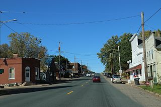
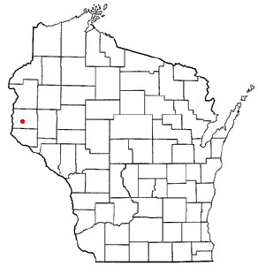
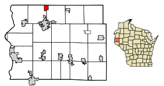
Wilson is a village in St. Croix County, Wisconsin, United States. The population was 184 at the 2010 census.

<span class="mw-page-title-main">Woodville, Wisconsin</span> Village in Wisconsin, United States

Woodville is a village in St. Croix County, Wisconsin, United States. The population was 1,344 at the 2010 census.

<span class="mw-page-title-main">Spring Valley, Wisconsin</span> Village in Wisconsin, United States

Spring Valley is a village in Pierce and St. Croix counties in Wisconsin, United States. The population was 1,401 at the 2020 census. Of those, 1,390 were in Pierce County and 11 in St. Croix County. The village is mostly within the Town of Spring Lake in Pierce County. Small parts also lie in the Town of Gilman, also in Pierce County, and the Town of Cady in St. Croix County.

<span class="mw-page-title-main">Turtle Lake, Wisconsin</span> Village in Wisconsin, United States

Turtle Lake is a village in Barron and Polk counties in the U.S. state of Wisconsin. Its population was 1,064 at the 2010 census. Of these, 972 were in Barron County and 93 were in Polk County. The village is located between the towns of Almena, in Barron County, and Beaver, in Polk County.

<span class="mw-page-title-main">Osceola, Wisconsin</span> Village in Wisconsin, United States

Osceola is a village in Polk County, Wisconsin, United States. The population was 2,765 at the 2020 census. Located mostly within the Town of Osceola, the village sits on the border with Minnesota, separated by the St. Croix River. It is along Wisconsin Highway 35.

<span class="mw-page-title-main">St. Croix Falls, Wisconsin</span> City in Wisconsin, United States

St. Croix Falls is a city in Polk County, Wisconsin, United States. The population was 2,208 at the 2020 census. The city is located within the Town of St. Croix Falls.

Hammond is a town in St. Croix County, Wisconsin, United States. The population was 947 at the 2000 census. The Village of Hammond is located within the town.

<span class="mw-page-title-main">Hammond, Wisconsin</span> Village in Wisconsin, United States

Hammond is a village in St. Croix County, Wisconsin, United States. The population was 1,922 at the 2010 census. The village is located within the Town of Hammond. Hammond was home to the Running of the Llamas.

<span class="mw-page-title-main">Star Prairie, Wisconsin</span> Village in Wisconsin, United States

Star Prairie is a village in St. Croix County in the U.S. state of Wisconsin. The population was 561 at the 2010 census. The village is located along the Apple River on the boundary between the Town of Star Prairie and the Town of Stanton.

Darien is a town in Walworth County, Wisconsin, United States. The population was 1,651 at the 2020 census. The Village of Darien is located within the town. The unincorporated community of Bardwell is located in the town. The unincorporated communities of Allen's Grove and Fairfield are also located partially in the town.

<span class="mw-page-title-main">Plainfield, Wisconsin</span> Village in Wisconsin, United States

Plainfield is a village in Waushara County, Wisconsin, United States. The village is located almost entirely within the Town of Plainfield. A tiny portion extends into adjacent Town of Oasis. The population was 897 at the 2010 census.

References

  1. "2019 U.S. Gazetteer Files". United States Census Bureau. Retrieved August 7, 2020.
  2. 1 2 "US Board on Geographic Names". United States Geological Survey. October 25, 2007. Retrieved January 31, 2008.
  3. 1 2 "U.S. Census website". United States Census Bureau . Retrieved November 18, 2012.
  4. 1 2 "Population and Housing Unit Estimates". United States Census Bureau. May 24, 2020. Retrieved May 27, 2020.
  5. 1 2 "U.S. Census website". United States Census Bureau . Retrieved January 31, 2008.
  6. Chicago and North Western Railway Company (1908). A History of the Origin of the Place Names Connected with the Chicago & North Western and Chicago, St. Paul, Minneapolis & Omaha Railways. p. 189.
  7. Callary, Edward (2016). Place Names of Wisconsin. Madison, WI: University of Wisconsin Press. p. 236. ISBN   978-0-299-30964-0.
  8. "Saint Croix County". Jim Forte Postal History. Retrieved April 4, 2015.
  9. "US Gazetteer files 2010". United States Census Bureau. Archived from the original on January 25, 2012. Retrieved November 18, 2012.
  10. "US Gazetteer files: 2010, 2000, and 1990". United States Census Bureau. February 12, 2011. Retrieved April 23, 2011.
  11. "Census of Population and Housing". Census.gov. Retrieved June 4, 2015.