Houlton, Wisconsin | |
|---|---|
Census-designated place | |
 Houlton, Wisconsin | |
| Coordinates: 45°03′38″N92°47′29″W / 45.06056°N 92.79139°W | |
| Country | United States |
| State | Wisconsin |
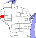
| County | St. Croix |
| Town | St. Joseph |
| Area | |
• Total | 1.021 sq mi (2.64 km2) |
| • Land | 1.021 sq mi (2.64 km2) |
| • Water | 0 sq mi (0 km2) |
| Elevation | 873 ft (266 m) |
| Population | |
• Total | 377 |
| • Density | 370/sq mi (140/km2) |
| Time zone | UTC-6 (Central (CST)) |
| • Summer (DST) | UTC-5 (CDT) |
| ZIP code | 54082 |
| Area code(s) | 715 & 534 |
| GNIS feature ID | 1581648 [2] |
Houlton is an unincorporated census-designated place located in the town of St. Joseph, St. Croix County, Wisconsin, United States. As of the 2010 census, its population was 386. [3] It is along Wisconsin Highways 35 and 64, Main Street, Hawk Street, and County Road E. Houlton is located across the St. Croix River from Stillwater, Minnesota. Houlton has no post office but has been assigned the ZIP code 54082. [4]