Ashland County | |
---|---|
Coordinates: 46°43′N90°34′W / 46.71°N 90.56°W | |
Country | United States |
State | Wisconsin |
Founded | March 27, 1860 |
Named for | Henry Clay's farm Ashland |
Seat | Ashland |
Largest city | Ashland |
Area | |
• Total | 2,292 sq mi (5,940 km2) |
• Land | 1,045 sq mi (2,710 km2) |
• Water | 1,247 sq mi (3,230 km2) 54% |
Population | |
• Total | 16,027 |
• Density | 15.3/sq mi (5.9/km2) |
Time zone | UTC−6 (Central) |
• Summer (DST) | UTC−5 (CDT) |
Congressional district | 7th |
Website | www |
Ashland County is a county located in the U.S. state of Wisconsin. As of the 2020 census, the population was 16,027. [1] Its county seat is Ashland. [2] The county was formed on March 27, 1860, from La Pointe County. [3] The county partly overlaps with the reservation of the Bad River Band of the Lake Superior Tribe of Chippewa Indians.
Ashland County was named in honor of the Lexington estate of Kentucky statesman Henry Clay, as one of the founders of the city of Ashland was an admirer of Clay. [4] [5]
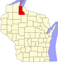
According to the U.S. Census Bureau, the county has a total area of 2,292 square miles (5,940 km2), of which 1,045 square miles (2,710 km2) is land and 1,247 square miles (3,230 km2) (54%) is water. [6] It is the second-largest county in Wisconsin by total area. The Apostle Islands are a small group of islands in Lake Superior, off the Bayfield Peninsula with the majority of the islands located in Ashland County — only Sand, York and Raspberry Islands are in Bayfield County.
Census | Pop. | Note | %± |
---|---|---|---|
1860 | 515 | — | |
1870 | 221 | −57.1% | |
1880 | 1,559 | 605.4% | |
1890 | 20,063 | 1,186.9% | |
1900 | 20,176 | 0.6% | |
1910 | 21,965 | 8.9% | |
1920 | 24,538 | 11.7% | |
1930 | 21,054 | −14.2% | |
1940 | 21,801 | 3.5% | |
1950 | 19,461 | −10.7% | |
1960 | 17,375 | −10.7% | |
1970 | 16,743 | −3.6% | |
1980 | 16,783 | 0.2% | |
1990 | 16,307 | −2.8% | |
2000 | 16,866 | 3.4% | |
2010 | 16,157 | −4.2% | |
2020 | 16,027 | −0.8% | |
U.S. Decennial Census [7] 1790–1960 [8] 1900–1990 [9] 1990–2000 [10] 2010 [11] 2020 [1] |
As of the census of 2020, [1] the population was 16,027. The population density was 15.3 inhabitants per square mile (5.9/km2). There were 9,407 housing units at an average density of 9.0 units per square mile (3.5 units/km2). The racial makeup of the county was 79.8% White, 13.0% Native American, 0.7% Black or African American, 0.5% Asian, 0.1% Pacific Islander, 0.3% from other races, and 5.6% from two or more races. Ethnically, the population was 2.4% Hispanic or Latino of any race.
As of the 2010 United States Census, there were 16,157 people living in the county. 84.6% were White, 11.1% Native American, 0.4% Asian, 0.3% Black or African American, 0.3% of some other race and 3.3% of two or more races. 1.9% were Hispanic or Latino (of any race). 25.6% were of German, 7.6% Finnish, 6.8% American, 6.5% Irish and 5.3% Norwegian ancestry. [12]
As of the census [13] of 2000, there were 16,866 people, 6,718 households, and 4,279 families living in the county. The population density was 16 people per square mile (6.2 people/km2). There were 8,883 housing units at an average density of 8 units per square mile (3.1 units/km2). The racial makeup of the county was 87.10% White, 0.21% Black or African American, 10.35% Native American, 0.31% Asian, 0.05% Pacific Islander, 0.29% from other races, and 1.69% from two or more races. 1.11% of the population were Hispanic or Latino of any race. 27.8% were of German, 8.4% Finnish, 7.4% Polish, 7.4% Norwegian, 7.3% Swedish and 5.4% Irish ancestry. 96.6% spoke English as their first language. The reservation of the Bad River Chippewa Band is partially located in the county.
There were 6,718 households, out of which 30.30% had children under the age of 18 living with them, 48.60% were married couples living together, 10.90% had a female householder with no husband present, and 36.30% were non-families. 30.80% of all households were made up of individuals, and 14.40% had someone living alone who was 65 years of age or older. The average household size was 2.39 and the average family size was 3.01.
In the county, the population was spread out, with 25.40% under the age of 18, 11.20% from 18 to 24, 25.80% from 25 to 44, 21.70% from 45 to 64, and 15.90% who were 65 years of age or older. The median age was 37 years. For every 100 females there were 97.10 males. For every 100 females age 18 and over, there were 91.10 males.
In 2017, there were 194 births, giving a general fertility rate of 73.1 births per 1000 women aged 15–44, the eleventh highest rate out of all 72 Wisconsin counties. [14] Additionally, there were no reported induced abortions performed on women of Ashland County residence in 2017. [15]
Ashland County is consistently Democratic. It has voted for the Democrat in every presidential election since 1932, with the exceptions of 1952 and 1956 when it backed Republican Dwight D. Eisenhower's two successful bids for the presidency.
Despite Ashland County's Democratic leanings, three consecutive district attorneys of Ashland County in the 1990s and early 2000s, each elected as Republicans, went on to hold major positions in state or federal politics. J.B. Van Hollen, district attorney from 1993 to 1999, later served as United States Attorney for the Western District of Wisconsin in the administration of President George W. Bush and as Attorney General of Wisconsin from 2007 to 2015. Van Hollen's successor as district attorney, Michael Gableman, who served from 1999 to 2002, was later a justice of the Wisconsin Supreme Court from 2008 to 2018. Gableman's successor as district attorney, Sean Duffy, who served from 2002 to 2010, served as the U.S. representative for Wisconsin's 7th congressional district from 2011 to 2019.
Year | Republican | Democratic | Third party | |||
---|---|---|---|---|---|---|
No. | % | No. | % | No. | % | |
2020 | 3,841 | 43.86% | 4,801 | 54.82% | 115 | 1.31% |
2016 | 3,303 | 41.12% | 4,226 | 52.61% | 503 | 6.26% |
2012 | 2,820 | 33.68% | 5,399 | 64.49% | 153 | 1.83% |
2008 | 2,634 | 30.72% | 5,818 | 67.86% | 122 | 1.42% |
2004 | 3,313 | 36.01% | 5,805 | 63.10% | 81 | 0.88% |
2000 | 3,038 | 38.50% | 4,356 | 55.21% | 496 | 6.29% |
1996 | 1,863 | 27.41% | 3,808 | 56.02% | 1,127 | 16.58% |
1992 | 2,372 | 28.26% | 4,213 | 50.20% | 1,808 | 21.54% |
1988 | 2,926 | 39.11% | 4,526 | 60.49% | 30 | 0.40% |
1984 | 3,517 | 42.54% | 4,680 | 56.60% | 71 | 0.86% |
1980 | 3,262 | 37.56% | 4,469 | 51.46% | 954 | 10.98% |
1976 | 3,045 | 38.25% | 4,688 | 58.89% | 228 | 2.86% |
1972 | 3,478 | 46.93% | 3,771 | 50.88% | 162 | 2.19% |
1968 | 2,557 | 35.74% | 4,147 | 57.96% | 451 | 6.30% |
1964 | 2,198 | 28.96% | 5,383 | 70.91% | 10 | 0.13% |
1960 | 3,470 | 42.70% | 4,644 | 57.14% | 13 | 0.16% |
1956 | 4,121 | 52.70% | 3,677 | 47.03% | 21 | 0.27% |
1952 | 4,451 | 53.50% | 3,828 | 46.01% | 41 | 0.49% |
1948 | 3,135 | 41.75% | 4,110 | 54.73% | 264 | 3.52% |
1944 | 3,183 | 40.60% | 4,609 | 58.80% | 47 | 0.60% |
1940 | 3,592 | 38.59% | 5,586 | 60.01% | 131 | 1.41% |
1936 | 2,439 | 28.10% | 5,904 | 68.01% | 338 | 3.89% |
1932 | 2,646 | 31.77% | 5,405 | 64.90% | 277 | 3.33% |
1928 | 3,639 | 49.36% | 3,570 | 48.43% | 163 | 2.21% |
1924 | 2,272 | 32.44% | 449 | 6.41% | 4,283 | 61.15% |
1920 | 4,005 | 70.94% | 1,081 | 19.15% | 560 | 9.92% |
1916 | 1,998 | 51.98% | 1,582 | 41.16% | 264 | 6.87% |
1912 | 937 | 26.83% | 1,451 | 41.54% | 1,105 | 31.63% |
1908 | 2,259 | 54.21% | 1,582 | 37.96% | 326 | 7.82% |
1904 | 3,406 | 71.40% | 1,004 | 21.05% | 360 | 7.55% |
1900 | 3,034 | 63.97% | 1,557 | 32.83% | 152 | 3.20% |
1896 | 2,738 | 59.70% | 1,743 | 38.01% | 105 | 2.29% |
1892 | 2,283 | 46.46% | 2,436 | 49.57% | 195 | 3.97% |
St. Croix County is a county in the U.S. state of Wisconsin. As of the 2020 census, the population was 93,536. Its county seat is Hudson. The county was created in 1840 and organized in 1849. St. Croix County is part of the Minneapolis-St. Paul-Bloomington, MN-WI Metropolitan Statistical Area. Between 2000 and 2010, it was the fastest-growing county in Wisconsin.
Sawyer County is a county in the U.S. state of Wisconsin. As of the 2020 census, its population was 18,074. Its county seat is Hayward. The county partly overlaps with the reservation of the Lac Courte Oreilles Band of Lake Superior Chippewa Indians.
Price County is a county in the U.S. state of Wisconsin. As of the 2020 census, the population was 14,054. Its county seat is Phillips.
Eau Claire County is a county located in the U.S. state of Wisconsin. As of the 2020 census, the population was 105,710. Its county seat is Eau Claire. The county took its name from the Eau Claire River.
Dunn County is a county in the U.S. state of Wisconsin. As of the 2020 census, the population was 45,440. Its county seat is Menomonie. Dunn County comprises the Menomonie Micropolitan Statistical Area and is included in the Eau Claire-Menomonie, WI Combined Statistical Area.
Chippewa County is a county located in the U.S. state of Wisconsin. It is named for the historic Chippewa people, also known as the Ojibwe, who long controlled this territory. As of the 2020 census, the population was 66,297. Its county seat is Chippewa Falls. The county was founded in 1845 from Crawford County, then in the Wisconsin Territory, and organized in 1853.
Burnett County is a county located in the U.S. state of Wisconsin. As of the 2020 census, the population was 16,526. Its county seat is Siren, with the majority of county governmental services located at the Burnett County Government Center. The county was created in 1856 and organized in 1865. The St. Croix Chippewa Indians of Wisconsin have reservation lands in Burnett County and are the county's largest employer.
Bayfield County is the northernmost county of the U.S. state of Wisconsin. As of the 2020 census, its population is 16,220. Its county seat is Washburn. The county was created in 1845 and organized in 1850. The Red Cliff Band of Lake Superior Chippewa has a reservation in Bayfield County and is the county's largest employer.
Barron County is a county located in the U.S. state of Wisconsin. As of the 2020 census, the population was 46,711. Its county seat is Barron. The county was created in 1859 and later organized in 1874.
Agenda is a town in Ashland County in the U.S. state of Wisconsin. The population was 422 at the 2010 census. The unincorporated communities of Holts Landing and Petes Landing are located in the town.
Chippewa is a town in Ashland County in the U.S. state of Wisconsin. The population was 374 at the 2010 census.
Odanah is an unincorporated community and census-designated place (CDP) in Ashland County, Wisconsin, in the town of Sanborn, United States, on the banks of the Bad River. The population was 47 at the 2020 census.
Sanborn is a town in Ashland County in the U.S. state of Wisconsin. The population was 1,331 at the 2010 census. The unincorporated communities of Bayfront, Birch, Birch Hill, Diaperville, Franks Field, New Odanah, Odanah, and Sedgwick are located in the town. Long Island, one of the Apostle Islands, is also a part of the town. The entire town is part of the Bad River Reservation of the Bad River Band of the Lake Superior Tribe of Chippewa Indians.
Shanagolden is a town in Ashland County in the U.S. state of Wisconsin. The population was 125 at the 2010 census. The unincorporated community of Shanagolden is located in the town.
Eileen is a town in Bayfield County, Wisconsin, United States. The population was 681 at the 2010 census. The unincorporated community of Ashland Junction is located in the town.
Washburn is a city and the county seat of Bayfield County, in the U.S. state of Wisconsin. The population was 2,051 at the 2020 census. The city is just east of and adjacent to the Town of Washburn. It is in northern Wisconsin, on the shore of Lake Superior's Chequamegon Bay.
Bayfield is a city in Bayfield County, Wisconsin, United States. The population was 584 at the 2020 census. This makes it the city with the smallest population in Wisconsin. In fact, for a new city to be incorporated today, state regulations require a population of at least 1,000 residents, so it would have to be incorporated as a village instead.
The Bad River LaPointe Band of the Lake Superior Tribe of Chippewa Indians or Bad River Tribe for short are a federally recognized tribe of Ojibwe people. The tribe had 6,945 members as of 2010. The Bad River Reservation is located on the south shore of Lake Superior and has a land area of about 193.11 square miles (500.15 km2) in northern Wisconsin, straddling Ashland and Iron counties. Odanah, the administrative and cultural center, is located five miles (8.0 km) east of the town of Ashland on U.S. Highway 2. The reservation population was 1,545 in 2020. Most of the reservation is managed as undeveloped forest and wetland, providing a habitat for wild rice and other natural resources.
Red Cliff Band of Lake Superior Chippewa is a band of Ojibwe Native Americans. The Red Cliff Band is located on the Red Cliff Indian Reservation, on Lake Superior in Bayfield County, Wisconsin. Red Cliff, Wisconsin, is the administrative center. Red Cliff is notable for being the band closest to the spiritual center of the Ojibwe nation, Madeline Island. As of November 2010, there were 5,312 enrolled members, with about half living on the reservation and the rest living in the city of Bayfield or the Belanger Settlement.
La Pointe is a town in Ashland County in the U.S. state of Wisconsin. The population was 428 at the 2020 census. The town includes all of the Apostle Islands except for the westernmost four, which lie in the towns of Bayfield and Russell in Bayfield County. The town includes the unincorporated community of La Pointe on Madeline Island, the largest of the Apostle Islands. The communities of Middleport and Old Fort are also located in the town. Its name in the Anishinaabe language is Mooningwanekaaning, meaning "The Home of the Golden Breasted Woodpecker".