Birch Hill, Wisconsin | |
|---|---|
 Birch Hill | |
| Coordinates: 46°31′15″N90°33′20″W / 46.52083°N 90.55556°W | |
| Country | United States |
| State | Wisconsin |
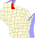
| County | Ashland |
| Area | |
• Total | 0.619 sq mi (1.60 km2) |
| • Land | 0.619 sq mi (1.60 km2) |
| • Water | 0 sq mi (0 km2) |
| Elevation | 1,079 ft (329 m) |
| Population | |
• Total | 295 |
| • Density | 480/sq mi (180/km2) |
| Time zone | UTC-6 (Central (CST)) |
| • Summer (DST) | UTC-5 (CDT) |
| Area codes | 715 & 534 |
| GNIS feature ID | 2585058 [2] |
Birch Hill is a census-designated place in the town of Sanborn, Ashland County, Wisconsin, United States. Its population was 295 at the 2020 census, a small increase from 293 at the 2010 census. [3]