
Bayfield County is the northernmost county of the U.S. state of Wisconsin. As of the 2020 census, its population is 16,220. Its county seat is Washburn. The county was created in 1845 and organized in 1850. The Red Cliff Band of Lake Superior Chippewa has a reservation in Bayfield County and is the county's largest employer.

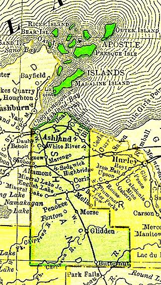
Ashland County is a county located in the U.S. state of Wisconsin. As of the 2020 census, the population was 16,027. Its county seat is Ashland. The county was formed on March 27, 1860, from La Pointe County. The county partly overlaps with the reservation of the Bad River Band of the Lake Superior Tribe of Chippewa Indians.
The Apostle Islands National Lakeshore is a U.S. national lakeshore consisting of 21 islands and shoreline encompassing 69,372 acres (28,074 ha) on the northern tip of Wisconsin on the shore of Lake Superior. It is known for its collection of historic lighthouses, sandstone sea caves, a few old-growth remnant forests, and natural animal habitats. It is featured on the America the Beautiful Quarters series.
The Apostle Islands are a group of 22 islands in Lake Superior, off the Bayfield Peninsula in northern Wisconsin. The majority of the islands are located in Ashland County—only Sand, York, Eagle, and Raspberry Islands are located in Bayfield County. All the islands except for Madeline Island are part of the Apostle Islands National Lakeshore. The islands in Ashland County are all in the Town of La Pointe, except for Long Island, which is in the Town of Sanborn, while those in Bayfield County are in the Towns of Russell and Bayfield.
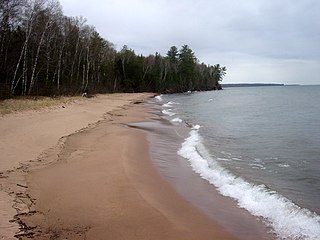
Cornucopia is an unincorporated census-designated place in the town of Bell in northern Bayfield County, Wisconsin, United States. It is situated on Lake Superior at the northern end of the Bayfield Peninsula. It is along Wisconsin Highway 13 and County Highway C. As of the 2010 census, its population was 98. The community borders the lake at Siskiwit Bay, between Roman's Point and Mawikwe Point. It is near a mainland portion of the Apostle Islands National Lakeshore, which features the Mawikwe Bay Sea Caves.

In the U.S. state of Wisconsin, the Lake Superior Lowland, also known as the Superior Coastal Plain, is a geographical region located in the far northern part of the state bordering Lake Superior. It covers about 1,250 square miles (3,200 km2), and does not extend beyond 20 miles (32 km) from the Lake Superior shore.
Michigan Island is one of the Apostle Islands located in western Lake Superior, off the Bayfield Peninsula, in northern Wisconsin. This island has no human inhabitants, and is managed by the National Park Service as part of the Apostle Islands National Lakeshore. It is centered at approximately 46.87° N 90.49° W and has a maximum elevation of 758' above sea level. Along its shores, it rises about 48 feet above Lake Superior's official elevation of 602'. The Michigan Island Light, which has two towers, is located on the island.
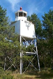
The Chequamegon Point Lighthouse is a lighthouse located on Long Island, one of the Apostle Islands, in Lake Superior in Ashland County, Wisconsin, near the city of Bayfield.

Chequamegon Bay is an inlet of Lake Superior in Ashland and Bayfield counties in the extreme northern part of Wisconsin.

State Trunk Highway 13 is a state highway running north–south across northwest and central Wisconsin. WIS 13 serves as a major north–south route connecting the communities of Wisconsin Dells, Wisconsin Rapids, Marshfield and Ashland. WIS 13 is part of the Lake Superior Circle Tour from its northern/western terminus to Ashland at is eastern junction with U.S. Highway 2 (US 2). The road also provides access to the Apostle Islands National Lakeshore off the Lake Superior shoreline at Bayfield. The highway is two-lane surface road with the exception of various urban multilane road sections.

Madeline Island is an island in Lake Superior. Now part of Ashland County, Wisconsin, it has long been a spiritual center of the Lake Superior Chippewa. Although the largest of the Apostle Islands, it is not included in the Apostle Islands National Lakeshore. It is the only island in the Apostle Island chain open to commercial development and private ownership.
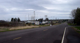
Herbster is a census-designated place (CDP) in the Town of Clover in Bayfield County, Wisconsin, United States, located on the south shore of Lake Superior. Herbster is 7 miles (11 km) east of Port Wing and 8 miles (13 km) west of Cornucopia on Wisconsin Highway 13, the main route through the community. The primary north/south route is by Lenawee Road / Forest Road 262, leading from Lake Superior to the Chequamegon National Forest. As of the 2010 census, its population was 104. Herbster has an area of 5.572 square miles (14.43 km2), all of it land.

KUWS is a public radio station in Superior, Wisconsin, licensed to the Board of Regents of the University of Wisconsin System and operated by the University of Wisconsin–Superior since January 21, 1966. KUWS is an affiliate of Wisconsin Public Radio's Ideas Network. It also airs university and student-produced programming weeknights with 91 Jazz St. from 7:00 to 10:00 and College Rock from 10:00 to 1:00 am.* KUWS broadcasts on 91.3 FM with 83,000 watts. KUWS was previously heard on translator station W275AF in the Ashland-Washburn-Bayfield area at 102.5 FM before September 12, 2011, when full-power WUWS (90.9) was launched from Ashland, replacing W275AF. WUWS continues to relay KUWS's schedule and is programmed from WPR's Superior studios.

Wisconsin, a state in the Midwestern United States, has a vast and diverse geography famous for its landforms created by glaciers during the Wisconsin glaciation 17,000 years ago. The state can be generally divided into five geographic regions—Lake Superior Lowland, Northern Highland, Central Plain, Eastern Ridges & Lowlands, and Western Upland. The southwestern part of the state, which was not covered by glaciers during the most recent ice age, is known as the Driftless Area. The Wisconsin glaciation formed the Wisconsin Dells, Devil's Lake, and the Baraboo Range. A number of areas are protected in the state, including Devil's Lake State Park, the Apostle Islands National Lakeshore, and the Chequamegon–Nicolet National Forest.

Sand Island is one of the Apostle Islands, in northern Wisconsin, in Lake Superior, and is part of the Apostle Islands National Lakeshore. It is located in the Town of Bayfield in Bayfield County. The Sand Island Light, the Sevona Cabin, the Shaw Farm and the West Bay Club are located on the island. There is another Sand Island Lake Chippewa in Sawyer County, Wisconsin.
Chequamegon Point is a peninsula that extends into Chequamegon Bay of Lake Superior in northern Wisconsin, in the Town of Sanborn, in Ashland County, Wisconsin. Long Island is an extension of Chequamegon Point. Most of Chequamegon Point is owned by the Bad River Band of the Lake Superior Tribe of Chippewa Indians. There is a lighthouse on the point.
Eagle Island is one of the Apostle Islands, in Lake Superior, in northern Wisconsin, and is part of the Apostle Islands National Lakeshore. The National Park Service does not allow entry onto the island in order not to disturb the birds that nest there. Eagle Island is the second-smallest and westernmost island in the Apostle islands. It is located in the Town of Bayfield in Bayfield County at 46°56′38″N091°02′11″W.

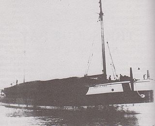
Lucerne was a commercial schooner. In November 1886, she sank due to bad weather in Lake Superior, off Long Island in Chequamegon Bay. The site of the wreck was added to the National Register of Historic Places in 1991.
Noquebay was a wooden schooner barge that sank in Lake Superior in Chequamegon Bay off Stockton Island. The wreck site was added to the National Register of Historic Places in 1992.
Siskiwit Lake is a small eutrophic lake on the Bayfield Peninsula in Bayfield County in northern Wisconsin in the United States. The lake is located about 4.5 miles (7.2 km) south of Siskiwit Bay, an arm of Lake Superior, and about 2 miles (3.2 km) north of the northern boundary of Chequamegon National Forest. Duluth-Superior is about 48 miles (77 km) to the west. Parts of the small town of Bell border the lake, and there are several houses and vacation cabins on the lake, most on the north shore. The nearest major road, Wisconsin Highway 13, is about 3.5 miles (5.6 km) to the north, and the nearest large town, Washburn, is about 14 miles (23 km) to the southeast, down County Trunk Highway C.
