Odanah, Wisconsin

Last updated

Odanah, Wisconsin
Oodena
Odanah Wisconsin Looking West US2.jpg
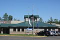
Odanah on U.S. Route 2
WIMap-doton-Odanah.png
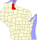
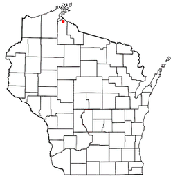
Location of Odanah, Wisconsin
Coordinates: 46°36′9″N90°40′57″W / 46.60250°N 90.68250°W / 46.60250; -90.68250
Country United States
State Wisconsin
County Ashland
Town Sanborn
Area
[1]
  Total2.773 sq mi (7.18 km2)
  Land2.617 sq mi (6.78 km2)
  Water0.156 sq mi (0.40 km2)
Elevation
[2]
610 ft (186 m)
Population
 (2020) [3]
  Total47
  Density18.0/sq mi (6.9/km2)
Time zone UTC-6 (Central (CST))
  Summer (DST) UTC-5 (CDT)
Area code(s) 715 & 534
FIPS code 55-59450 [4]
GNIS feature ID1570746 [2]

Odanah (Ojibwe : Oodena) is an unincorporated community and census-designated place (CDP) in Ashland County, Wisconsin, in the town of Sanborn, United States, on the banks of the Bad River. The population was 47 at the 2020 census. [3]

Contents

Odanah is the cultural and administrative center of the Bad River Chippewa Band of the Chippewa. [5]

For statistical purposes, the U.S. Census Bureau distinguishes Odanah from New Odanah, which has most of the community's population. In local parlance, the names are used interchangeably. Official state and county maps from the Wisconsin DOT only show Odanah. [6] [7]

History

A post office called Odanah has been in operation since 1855. [8] The name is from an Ojibwe language word, now spelled oodena, meaning "village." [9]

A 1960 flood led to the establishment of the Bad River Housing Authority, which relocated thousands of Odanah residents to higher ground a few miles down the road, away from the flood plain. [10]

Geography

Odanah is located at 46°36′9″N90°40′57″W / 46.60250°N 90.68250°W / 46.60250; -90.68250 (46.602594, -90.682582), [11] along the Bad River. [12]

According to the United States Census Bureau, the CDP has a total area of 2.77 square miles (7.18 km2), of which 2.62 square miles (6.78 km2) is land and 0.16 square miles (0.41 km2) is water. [1]

Demographics

As of the census [4] of 2000, there were 254 people, 94 households, and 64 families residing in the CDP. The population density was 165.2 people per square mile (63.7/km2). There were 104 housing units at an average density of 67.6/sq mi (26.1/km2). The racial makeup of the CDP was 4.72% White, 92.52% Native American, and 2.76% from two or more races. Hispanic or Latino of any race were 2.36% of the population.

There were 94 households, out of which 37.2% had children under the age of 18 living with them, 18.1% were married couples living together, 39.4% had a female householder with no husband present, and 30.9% were non-families. 26.6% of all households were made up of individuals, and 10.6% had someone living alone who was 65 years of age or older. The average household size was 2.70 and the average family size was 3.23.

In the CDP, the population was spread out, with 36.6% under the age of 18, 8.7% from 18 to 24, 27.2% from 25 to 44, 20.5% from 45 to 64, and 7.1% who were 65 years of age or older. The median age was 31 years. For every 100 females, there were 82.7 males. For every 100 females age 18 and over, there were 64.3 males.

The median income for a household in the CDP was $25,156, and the median income for a family was $24,125. Males had a median income of $25,000 versus $19,063 for females. The per capita income for the CDP was $9,950. About 23.9% of families and 29.7% of the population were below the poverty line, including 45.6% of those under the age of eighteen and none of those 65 or over.

Notable people

Images

See also

Related Research Articles

<span class="mw-page-title-main">Ashland County, Wisconsin</span> County in Wisconsin, United States

Ashland County is a county located in the U.S. state of Wisconsin. As of the 2020 census, the population was 16,027. Its county seat is Ashland. The county was formed on March 27, 1860, from La Pointe County. The county partly overlaps with the reservation of the Bad River Band of the Lake Superior Tribe of Chippewa Indians.

Westwood is a census-designated place in Boyd County, Kentucky, United States. The population was 4,387at the 2020 census. A suburb of Ashland, the two cities are closely affiliated, sharing a ZIP code and bus system. Westwood is located on a flat to hilly elevation just west of the Ohio River. The flat hilltop is unusual to eastern Kentucky and was created by the preglacial Teays River which existed in ancient times and flowed in the opposite direction of the Ohio River. Westwood is part of the Huntington–Ashland metropolitan area.

<span class="mw-page-title-main">Acushnet Center, Massachusetts</span> Census-designated place in Massachusetts, United States

Acushnet Center is a census-designated place (CDP) in the town of Acushnet in Bristol County, Massachusetts, United States. The population was 3,073 at the 2010 census.

<span class="mw-page-title-main">Little Rock, Beltrami County, Minnesota</span> Census-designated place in Minnesota, US

Little Rock is a census-designated place (CDP) within the Lower Red Lake unorganized territory in Beltrami County, Minnesota, United States. The population was 1,208 at the 2010 census.

<span class="mw-page-title-main">Naschitti, New Mexico</span> CDP in New Mexico, United States

Naschitti is a census-designated place (CDP) in San Juan County, New Mexico, United States. The population was 360 at the 2000 census. It is part of the Farmington Metropolitan Statistical Area. The town was established in 1886, when Tom Bryan set up a trading post east of the Chuska Mountains. With a Navajo name, Naschitti means "badger springs."

<span class="mw-page-title-main">Belcourt, North Dakota</span> CDP in North Dakota, United States

Belcourt is a census-designated place (CDP) in Rolette County, North Dakota, United States. It is within the Turtle Mountain Indian Reservation. The population was 1,510 at the 2020 census.

<span class="mw-page-title-main">Burlington, Ohio</span> Census-designated place in Ohio, United States

Burlington is an unincorporated community and census-designated place in Lawrence County, Ohio, United States, along the Ohio River. The population was 2,416 at the 2020 census. Connected to neighboring Huntington, West Virginia and connected via the West Huntington Bridge over the Ohio River, it is part of the Huntington–Ashland metropolitan area. Burlington was once the leading community of Lawrence County, being the first county seat and the location of the county's first post office.

Gregory is a census-designated place (CDP) in Rogers County, Oklahoma, United States. The population was 150 at the 2000 census.

<span class="mw-page-title-main">Ashland Heights, South Dakota</span> CDP in South Dakota, United States

Ashland Heights is a census-designated place (CDP) and unincorporated community in Pennington County, South Dakota, United States. The population was 678 at the 2020 census.

<span class="mw-page-title-main">Parkwood, Washington</span> CDP in Washington, United States

Parkwood is a census-designated place (CDP) in Kitsap County, Washington, United States. The population was 7,126 at the 2010 census.

<span class="mw-page-title-main">Agenda, Wisconsin</span> Town in Wisconsin, United States

Agenda is a town in Ashland County in the U.S. state of Wisconsin. The population was 422 at the 2010 census. The unincorporated communities of Holts Landing and Petes Landing are located in the town.

<span class="mw-page-title-main">Chippewa, Wisconsin</span> Town in Wisconsin, United States

Chippewa is a town in Ashland County in the U.S. state of Wisconsin. The population was 374 at the 2010 census.

<span class="mw-page-title-main">Marengo, Wisconsin</span> Town in Wisconsin, United States

Marengo is a town in Ashland County in the U.S. state of Wisconsin. The population was 390 at the 2010 census.

<span class="mw-page-title-main">Mellen, Wisconsin</span> City in Wisconsin, United States

Mellen is a city in Ashland County in the U.S. state of Wisconsin. The population was 698 at the 2020 census.

<span class="mw-page-title-main">Sanborn, Wisconsin</span> Town in Wisconsin, United States

Sanborn is a town in Ashland County in the U.S. state of Wisconsin. The population was 1,331 at the 2010 census. The unincorporated communities of Bayfront, Birch, Birch Hill, Diaperville, Franks Field, New Odanah, Odanah, and Sedgwick are located in the town. Long Island, one of the Apostle Islands, is also a part of the town. The entire town is part of the Bad River Reservation of the Bad River Band of the Lake Superior Tribe of Chippewa Indians.

<span class="mw-page-title-main">Little Round Lake, Wisconsin</span> CDP in Wisconsin, United States

Little Round Lake is a census-designated place (CDP) in the town of Bass Lake, Sawyer County, Wisconsin, United States. The population was 1,081 at the 2010 census. It is the largest community on the reservation of the federally recognized tribe of the Lac Courte Oreilles Band of Lake Superior Chippewa Indians.

<span class="mw-page-title-main">Lake Wisconsin, Wisconsin</span> CDP in Wisconsin, United States

Lake Wisconsin is a census-designated place (CDP) in Columbia and Sauk counties, in the towns of Lodi and Merrimac, in Wisconsin, United States. The population was 4,189 at the 2010 census.

<span class="mw-page-title-main">Lac du Flambeau (CDP), Wisconsin</span> CDP in Wisconsin, United States

Lac du Flambeau is a census-designated place (CDP) in the town of Lac du Flambeau in Vilas County, Wisconsin, United States. The population was 1,845 at the 2020 census. Lac du Flambeau is the major community for the Lac du Flambeau Band of Lake Superior Chippewa tribe.

<span class="mw-page-title-main">Bad River Band of the Lake Superior Tribe of Chippewa Indians</span> Indian tribe in Wisconsin, United States

The Bad River LaPointe Band of the Lake Superior Tribe of Chippewa Indians or Bad River Tribe for short are a federally recognized tribe of Ojibwe people. The tribe had 6,945 members as of 2010. The Bad River Reservation is located on the south shore of Lake Superior and has a land area of about 193.11 square miles (500.15 km2) in northern Wisconsin, straddling Ashland and Iron counties. Odanah, the administrative and cultural center, is located five miles (8.0 km) east of the town of Ashland on U.S. Highway 2. The reservation population was 1,545 in 2020. Most of the reservation is managed as undeveloped forest and wetland, providing a habitat for wild rice and other natural resources.

<span class="mw-page-title-main">Red Cliff Band of Lake Superior Chippewa</span> Band of Ojibwe Native Americans based in Bayfield County, Wisconsin

Red Cliff Band of Lake Superior Chippewa is a band of Ojibwe Native Americans. The Red Cliff Band is located on the Red Cliff Indian Reservation, on Lake Superior in Bayfield County, Wisconsin. Red Cliff, Wisconsin, is the administrative center. Red Cliff is notable for being the band closest to the spiritual center of the Ojibwe nation, Madeline Island. As of November 2010, there were 5,312 enrolled members, with about half living on the reservation and the rest living in the city of Bayfield or the Belanger Settlement.

References

  1. 1 2 "2020 Gazetteer Files". census.gov. U.S. Census Bureau. Retrieved July 14, 2022.
  2. 1 2 "US Board on Geographic Names". United States Geological Survey. October 25, 2007. Retrieved January 31, 2008.
  3. 1 2 "2020 Decennial Census: Odanah CDP, Wisconsin". data.census.gov. U.S. Census Bureau. Retrieved July 14, 2022.
  4. 1 2 "U.S. Census website". United States Census Bureau . Retrieved January 31, 2008.
  5. Rivero, Nicolas (August 25, 2017). "The Smallest Town in Each of the 50 States". Mental Floss. Retrieved June 25, 2018.
  6. "Ashland County Map" (PDF). Wisconsin Department of Transportation. Retrieved July 14, 2022.
  7. "Official Wisconsin highway map". Wisconsin Department of Transportation. Retrieved July 14, 2022.
  8. "Ashland County". Jim Forte Postal History. Retrieved March 24, 2015.
  9. Waldman, Carl; Braun, Molly (2009). Atlas of the North American Indian. Infobase Publishing. p. 380. ISBN   978-1-4381-2671-5.
  10. Hersher, Rebecca (August 15, 2018). "Wisconsin Reservation Offers A Climate Success Story And A Warning". NPR.org. Retrieved December 1, 2019.
  11. "US Gazetteer files: 2010, 2000, and 1990". United States Census Bureau. February 12, 2011. Retrieved April 23, 2011.
  12. DeLorme (1992), Wisconsin Atlas & Gazetteer, Freeport, Maine: DeLorme, p. 103 ISBN   0-89933-247-1