Sanborn, Wisconsin

Last updated

Sanborn, Wisconsin
WIMap-doton-Sanborn.png
Location of Sanborn, Wisconsin
Coordinates: 46°32′29″N90°40′19″W / 46.54139°N 90.67194°W / 46.54139; -90.67194
Country Flag of the United States.svg  United States
State Flag of Wisconsin.svg  Wisconsin
County Ashland
FoundedMarch 23, 1899
Named for Senator A.W. Sanborn
Area
  Total161.0 sq mi (416.9 km2)
  Land157.1 sq mi (406.9 km2)
  Water3.9 sq mi (10.0 km2)
Elevation
[1]
735 ft (224 m)
Population
 (2010)
  Total1,331
  Density9/sq mi (3.3/km2)
Time zone UTC-6 (Central (CST))
  Summer (DST) UTC-5 (CDT)
Area code(s) 715 & 534
FIPS code 55-71350 [2]
GNIS feature ID1584096 [1]

Sanborn is a town in Ashland County in the U.S. state of Wisconsin. The population was 1,331 at the 2010 census. [3] The unincorporated communities of Bayfront, Birch, Birch Hill, Diaperville, Franks Field, New Odanah, Odanah, and Sedgwick are located in the town. Long Island, one of the Apostle Islands, is also a part of the town. The entire town is part of the Bad River Reservation of the Bad River Band of the Lake Superior Tribe of Chippewa Indians.

Contents

History

The town was created on March 23, 1899, and supposedly named after Senator Albert W. Sanborn, a member of the Wisconsin State Senate, who held a large area of land in the vicinity. [4]

Geography

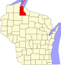
Sanborn is located in northern Ashland County, along the shore of Lake Superior. It is bordered by the city of Ashland and the town of Gingles to the west, by the town of White River to the west and the south, and by the towns of Ashland and Morse to the south. To the east are the towns of Gurney and Saxon in Iron County. The town of La Pointe occupies the Apostle Islands in Lake Superior, to the north.

The Bad River flows south to north through the town, entering Lake Superior northeast of the community of Odanah. U.S. Route 2 crosses the town, leading west to downtown Ashland and east to Ironwood, Michigan.

According to the United States Census Bureau, the town has a total area of 161.0 square miles (416.9 km2), of which 157.1 square miles (406.9 km2) is land and 3.9 square miles (10.0 km2), or 2.40%, is water. [3]

Demographics

As of the census [2] of 2000, there were 1,272 people, 428 households, and 321 families residing in the town. The population density was 8.1 people per square mile (3.1/km2). There were 531 housing units at an average density of 3.4 per square mile (1.3/km2). The racial makeup of the town was 12.97% White, 84.51% Native American, 0.08% Asian, 0.16% from other races, and 2.28% from two or more races. Hispanic or Latino of any race were 3.22% of the population.

There were 428 households, out of which 43.0% had children under the age of 18 living with them, 32.5% were married couples living together, 30.6% had a female householder with no husband present, and 24.8% were non-families. 21.0% of all households were made up of individuals, and 6.5% had someone living alone who was 65 years of age or older. The average household size was 2.97 and the average family size was 3.39.

In the town, the population was spread out, with 38.8% under the age of 18, 7.6% from 18 to 24, 28.0% from 25 to 44, 19.9% from 45 to 64, and 5.7% who were 65 years of age or older. The median age was 29 years. For every 100 females, there were 98.8 males. For every 100 females age 18 and over, there were 86.8 males.

The median income for a household in the town was $26,711, and the median income for a family was $27,625. Males had a median income of $25,150 versus $20,272 for females. The per capita income for the town was $11,664. About 23.7% of families and 27.4% of the population were below the poverty line, including 40.8% of those under age 18 and 5.9% of those age 65 or over.

46°32′29″N90°40′19″W / 46.54139°N 90.67194°W / 46.54139; -90.67194

Related Research Articles

<span class="mw-page-title-main">Ashland County, Wisconsin</span> County in Wisconsin, United States

Ashland County is a county located in the U.S. state of Wisconsin. As of the 2020 census, the population was 16,027. Its county seat is Ashland. The county was formed on March 27, 1860, from La Pointe County. The county partly overlaps with the reservation of the Bad River Band of the Lake Superior Tribe of Chippewa Indians.

<span class="mw-page-title-main">Sanbornton, New Hampshire</span> Town in New Hampshire, United States

Sanbornton is a town in Belknap County, New Hampshire, United States. The population was 3,026 at the 2020 census. It includes the villages of North Sanbornton and Gaza.

<span class="mw-page-title-main">Agenda, Wisconsin</span> Town in Wisconsin, United States

Agenda is a town in Ashland County in the U.S. state of Wisconsin. The population was 422 at the 2010 census. The unincorporated communities of Holts Landing and Petes Landing are located in the town.

<span class="mw-page-title-main">Gingles, Wisconsin</span> Town in Wisconsin, United States

Gingles is a town in Ashland County in the U.S. state of Wisconsin. The population was 778 at the 2010 census. The unincorporated community of White River is located in the town.

<span class="mw-page-title-main">Gordon, Ashland County, Wisconsin</span> Town in Wisconsin, United States

Gordon is a town in Ashland County in the U.S. state of Wisconsin. The population was 283 at the 2010 census. The unincorporated communities of Clam Lake and Morse are located in the town.

<span class="mw-page-title-main">Marengo, Wisconsin</span> Town in Wisconsin, United States

Marengo is a town in Ashland County in the U.S. state of Wisconsin. The population was 390 at the 2010 census.

<span class="mw-page-title-main">Mellen, Wisconsin</span> City in Wisconsin, United States

Mellen is a city in Ashland County in the U.S. state of Wisconsin. The population was 698 at the 2020 census.

<span class="mw-page-title-main">Odanah, Wisconsin</span> Census-designated place in Wisconsin, United States

Odanah is an unincorporated community and census-designated place (CDP) in Ashland County, Wisconsin, in the town of Sanborn, United States, on the banks of the Bad River. The population was 47 at the 2020 census.

<span class="mw-page-title-main">White River, Wisconsin</span> Town in Wisconsin, United States

White River is a town in Ashland County, Wisconsin, United States. The population was 921 at the 2010 census. The census-designated place of Marengo and unincorporated communities of Sanborn and part of Jolmaville are located in the town.

<span class="mw-page-title-main">Iron River, Wisconsin</span> Town in Wisconsin, United States

Iron River is a town in Bayfield County, Wisconsin, United States. The population was 1,123 at the 2010 census. The census-designated place of Iron River is located in the town. The unincorporated community of Topside is also located in the town.

<span class="mw-page-title-main">Brule, Wisconsin</span> Town in Wisconsin, United States

Brule is a town in Douglas County, Wisconsin, United States. The population was 591 at the 2000 census. The town takes its name from the nearby Bois Brule River, which flows north into Lake Superior. The census-designated place of Brule and unincorporated communities of Bellwood, Waino, and Winneboujou are located in the town of Brule.

<span class="mw-page-title-main">Farmington, Jefferson County, Wisconsin</span> Town in Wisconsin, United States

Farmington is a town in Jefferson County, Wisconsin, United States. The population as of the 2010 census was 1,380.

<span class="mw-page-title-main">Elcho, Wisconsin</span> Town in Wisconsin, United States

Elcho is a town in Langlade County, Wisconsin, United States. The population was 1,233 at the 2010 census. The census-designated places of Elcho, Post Lake, and part of Summit Lake are located in the town. The area is served by the Elcho Fire and Rescue Department.

<span class="mw-page-title-main">Phillips, Wisconsin</span> City in Wisconsin, United States

Phillips is a city and the county seat of Price County, Wisconsin, United States. The population was 1,478 at the 2010 census.

<span class="mw-page-title-main">Washburn, Wisconsin</span> City in Wisconsin, United States

Washburn is a city and the county seat of Bayfield County, in the U.S. state of Wisconsin. The population was 2,051 at the 2020 census. The city is just east of and adjacent to the Town of Washburn. It is in northern Wisconsin, on the shore of Lake Superior's Chequamegon Bay.

Solon Springs is a town in Douglas County, Wisconsin, United States. As of the 2010 census, the town had a total population of 910. The Village of Solon Springs is located within the town. The unincorporated community of Sauntry is also located in the town.

<span class="mw-page-title-main">Hayward (town), Wisconsin</span> Town in Wisconsin, United States

Hayward is a town in Sawyer County, Wisconsin, United States. The population was 3,279 at the 2000 census. The town is located near the City of Hayward. The census-designated place of Chief Lake is located in the town.

<span class="mw-page-title-main">Bayfield, Wisconsin</span> City in Wisconsin, United States

Bayfield is a city in Bayfield County, Wisconsin, United States. The population was 584 at the 2020 census. This makes it the city with the smallest population in Wisconsin. In fact, for a new city to be incorporated today, state regulations require a population of at least 1,000 residents, so it would have to be incorporated as a village instead.

<span class="mw-page-title-main">Bad River Band of the Lake Superior Tribe of Chippewa Indians</span> Indian tribe in Wisconsin, United States

The Bad River LaPointe Band of the Lake Superior Tribe of Chippewa Indians or Bad River Tribe for short are a federally recognized tribe of Ojibwe people. The tribe had 6,945 members as of 2010. The Bad River Reservation is located on the south shore of Lake Superior and has a land area of about 193.11 square miles (500.15 km2) in northern Wisconsin, straddling Ashland and Iron counties. Odanah, the administrative and cultural center, is located five miles (8.0 km) east of the town of Ashland on U.S. Highway 2. The reservation population was 1,545 in 2020. Most of the reservation is managed as undeveloped forest and wetland, providing a habitat for wild rice and other natural resources.

<span class="mw-page-title-main">La Pointe (town), Wisconsin</span> Town in Wisconsin, United States

La Pointe is a town in Ashland County in the U.S. state of Wisconsin. The population was 428 at the 2020 census. The town includes all of the Apostle Islands except for the westernmost four, which lie in the towns of Bayfield and Russell in Bayfield County. The town includes the unincorporated community of La Pointe on Madeline Island, the largest of the Apostle Islands. The communities of Middleport and Old Fort are also located in the town. Its name in the Anishinaabe language is Mooningwanekaaning, meaning "The Home of the Golden Breasted Woodpecker".

References

  1. 1 2 "US Board on Geographic Names". United States Geological Survey. October 25, 2007. Retrieved January 31, 2008.
  2. 1 2 "U.S. Census website". United States Census Bureau . Retrieved January 31, 2008.
  3. 1 2 "Geographic Identifiers: 2010 Demographic Profile Data (G001): Sanborn town, Ashland County, Wisconsin". U.S. Census Bureau, American Factfinder. Archived from the original on February 12, 2020. Retrieved September 6, 2013.
  4. Sanborn (origin of place name), Wisconsin Historical Society