North York, Wisconsin | |
|---|---|
 Downtown North York | |
 North York  North York | |
| Coordinates: 46°23′34″N90°46′40″W / 46.39278°N 90.77778°W | |
| Country | |
| State | |
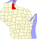
| County | Ashland |
| Town | Ashland |
| Elevation | 889 ft (271 m) |
| Time zone | UTC-6 (Central (CST)) |
| • Summer (DST) | UTC-5 (CDT) |
| Area codes | 715 & 534 |
| GNIS feature ID | 1570521 [1] |
North York is an unincorporated community located in the town of Ashland, Ashland County, Wisconsin, United States. [1] It is situated on Wisconsin Highway 13.