Vernon County is a county in the U.S. state of Wisconsin. As of the 2020 census, the population was 30,714. Its county seat is Viroqua.

La Crosse is a city in and the county seat of La Crosse County, Wisconsin, United States. Positioned alongside the Mississippi River, La Crosse is the largest city on Wisconsin's western border. La Crosse's population was 52,680 as of the 2020 census. The city forms the core of the La Crosse–Onalaska metropolitan area, which includes all of La Crosse County and Houston County, Minnesota, with a population of 139,627.

The Wisconsin River is a tributary of the Mississippi River in the U.S. state of Wisconsin. At approximately 430 miles long, it is the state's longest river. The river's name was first recorded in 1673 by Jacques Marquette as "Meskousing" from his Indian guides - most likely Miami for "river running through a red place."

Coulee, or coulée, is any of various different landforms, all of which are kinds of valleys or drainage zones. The word coulee comes from the Canadian French coulée, from French couler 'to flow'.

The Driftless Area, also known as Bluff Country and the Paleozoic Plateau, is a topographical and cultural region in the Midwestern United States that comprises southwestern Wisconsin, southeastern Minnesota, northeastern Iowa, and the extreme northwestern corner of Illinois. The Driftless Area is a USDA Level III Ecoregion: Ecoregion 52. The Driftless Area takes up a large portion of the Upper Midwest forest–savanna transition. The eastern section of the Driftless Area in Minnesota is called the Blufflands, due to the steep bluffs and cliffs around the river valleys. The western half is known as the Rochester Plateau, which is flatter than the Blufflands. The Coulee Region is the southwestern part of the Driftless Area in Wisconsin. It is named for its numerous ravines.

The Eastern Ridges and Lowlands is a geographical region in the eastern part of the U.S. state of Wisconsin, between Green Bay in the north, and the border with Illinois in the south. Lake Michigan lies to the east of the region.

Great River Bluffs State Park is a state park of Minnesota, United States, on the Mississippi River southeast of Winona. Originally known as O. L. Kipp State Park, it was renamed in the late 1990s to describe better its resources. The park preserves steep-sided bluffs rising 500 feet (150 m) above the river and the narrow valleys between them, which support rare and fragile plant communities. Two of the bluffs have received further protection under the Minnesota Scientific and Natural Areas program, which are known as King's and Queen's Bluff Scientific and Natural Area.

The Dissected Till Plains are physiographic sections of the Central Lowlands province, which in turn is part of the Interior Plains physiographic division of the United States, located in southern and western Iowa, northeastern Kansas, the southwestern corner of Minnesota, northern Missouri, eastern Nebraska, and southeastern South Dakota.

The Black River is a river in west-central Wisconsin and a tributary of the Mississippi River. The river is approximately 190 miles (310 km) long. During the 19th century, pine logs were rafted down the Black, heading for sawmills at La Crosse and points beyond.
Wisconsin's 3rd congressional district covers most of the Driftless Area in southwestern and western Wisconsin. The district includes the cities of Eau Claire, La Crosse, and Stevens Point, as well as many Wisconsin-based exurbs of the Minneapolis-St. Paul metropolitan area. It borders the states of Minnesota, Iowa, and Illinois. Republican Derrick Van Orden has represented the district since 2023.

State Trunk Highway 131 is a 78.9-mile (127.0 km) state highway in the U.S. state of Wisconsin. The highway is located in Wisconsin's Driftless Area, passing through Crawford, Vernon, Richland, and Monroe counties. It runs from WIS 60 near Wauzeka north to US Highway 12 and WIS 16 in Tomah. WIS 131 is maintained by the Wisconsin Department of Transportation (WisDOT).

The geology of Minnesota comprises the rock, minerals, and soils of the U.S. state of Minnesota, including their formation, development, distribution, and condition.

Wildcat Mountain State Park is a state park of Wisconsin, United States, on the Kickapoo River in the Driftless Area. Sandstone bluffs topped with limestone, two of which are Wildcat Mountain and Mount Pisgah, provide views over the narrow valley of the river and its tributaries. The Kickapoo Valley Reserve is immediately adjacent and forms a continuous protected area. Wildcat Mountain State Park is open for year-round recreation including hiking, canoeing, fishing, and cross-country skiing. The 3,643-acre (1,474 ha) park is located in Vernon County near the town of Ontario, Wisconsin.

Wisconsin, a state in the Midwestern United States, has a vast and diverse geography famous for its landforms created by glaciers during the Wisconsin glaciation 17,000 years ago. The state can be generally divided into five geographic regions—Lake Superior Lowland, Northern Highland, Central Plain, Eastern Ridges & Lowlands, and Western Upland. The southwestern part of the state, which was not covered by glaciers during the most recent ice age, is known as the Driftless Area. The Wisconsin glaciation formed the Wisconsin Dells, Devil's Lake, and the Baraboo Range. A number of areas are protected in the state, including Devil's Lake State Park, the Apostle Islands National Lakeshore, and the Chequamegon–Nicolet National Forest.
Ocooch Mountains are a place name for the Western Upland area of Wisconsin also known as the Driftless Region, meaning un-glaciated, lacking glacial drift or the Paleozoic Plateau, referring to a geologic era, Greek for "ancient life". The lack of glaciated terrain accounts for high hills, bluffs, and ridges. The Chippewa, Black, La Crosse, Kickapoo, Baraboo, Lemonweir, Pine, Wisconsin, Grant, Platte and Pecatonia rivers and their tributaries create deeply eroded valleys that contrast the nearby peaks. One dramatic example is Wildcat Mountain State Park. The Baraboo Range anchors the eastern edge where the Wisconsin River turns and runs through the area to the Mississippi River. The Baraboo Range is a monadnock in Sauk and Columbia Counties and a National Natural Landmark formed 1.6 billion years ago featuring Devil's Lake, an endorheic lake.
There are a variety of schema for dividing Wisconsin into regions.
The Windrow Formation is a geologic formation in Minnesota named after Windrow Bluff on Fort McCoy, Monroe County, Wisconsin. It preserves fossils dating back to the Cretaceous period.
The geology of Wisconsin includes Precambrian crystalline basement rock over three billion years old. A widespread marine environment during the Paleozoic flooded the region, depositing sedimentary rocks which cover most of the center and south of the state.
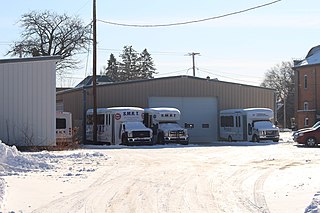
Scenic Mississippi Regional Transit or SMRT is a commuter bus system serving the Driftless Area of Wisconsin. It provides four routes which serve Crawford County, La Crosse County, Monroe County and Vernon County. It was recognized by Wisconsin Rural Partners as one of Wisconsin’s Top Rural Development Initiatives in 2017.
