Black River (Wisconsin)

Last updated • 4 min readFrom Wikipedia, The Free Encyclopedia
Black River
Falls of the Black River (WI).jpg
Black River dam in Black River Falls
Blackwirivermap.png
Map of the Black River watershed
Physical characteristics
Source 
  locationBlack Lake, Taylor County, Wisconsin
Mouth  
  location
Mississippi River in La Crosse, Wisconsin
  elevation
630 ft (190 m) [1]
Length190 miles (310 km)
Basin sizeApproximately 2,400 sq mi (6,200 km2) [2]
Basin features
River system Mississippi River

The Black River is a river in west-central Wisconsin and a tributary of the Mississippi River. The river is approximately 190 miles (310 km) long. [3] During the 19th century, pine logs were rafted down the Black, heading for sawmills at La Crosse and points beyond.

Contents

Geography

Delta of the Black River at the Mississippi River across from Great River Bluffs State Park, Minnesota. Black River Delta WI.jpg
Delta of the Black River at the Mississippi River across from Great River Bluffs State Park, Minnesota.

The river begins in central Wisconsin, rising in Taylor County at 45°19′00″N90°15′20″W / 45.31667°N 90.25556°W / 45.31667; -90.25556 (Black River (source)) approximately 2.5 miles (4.0 km) west of the village of Rib Lake. [1] It flows south-southwest through Medford, Greenwood, Neillsville and Black River Falls. The Black River first mingles with the Mississippi River in Lake Onalaska in the Upper Mississippi River National Wildlife and Fish Refuge. The lower 10 miles (16 km) of the river channel have been absorbed by Lake Onalaska, an impoundment of the Mississippi River formed by Lock and Dam No. 7 at Onalaska. The river exits Lake Onalaska through a channel between French Island and the city of Onalaska and rejoins the Mississippi River at 43°49′12″N91°15′26″W / 43.82000°N 91.25722°W / 43.82000; -91.25722 (Black River (mouth)) , [1] northwest of La Crosse.

The Black River can be divided into two sections by the dam at Black River Falls. The upstream section averages 6.6 feet/mile gradient, while the lower section through the Driftless Area only averages 1.7 feet/mile gradient. [4] An additional distinction is that the upper section has a substrate predominantly rocky and soil that contributes tannin, while the lower section has a predominantly sandy substrate. The tannin content of the water is the source of the river's name.

The East Fork Black River rises in Wood County at 44°35′26″N90°17′49″W / 44.59056°N 90.29694°W / 44.59056; -90.29694 (East Fork Black River (source)) , southwest of Marshfield and flows 57.5 miles (92.5 km) [3] south and west into Lake Arbutus on the Black River at 44°25′50″N90°41′41″W / 44.43056°N 90.69472°W / 44.43056; -90.69472 (East Fork Black River (mouth)) . [5]

The Little Black River is formed by the confluence of the East and West Branches at 45°07′51″N90°16′00″W / 45.13083°N 90.26667°W / 45.13083; -90.26667 (Little Black River (source)) and flows into the Black River at 45°06′39″N90°20′57″W / 45.11083°N 90.34917°W / 45.11083; -90.34917 (Little Black River (mouth)) south of Medford. [6] The West Branch Little Black River rises at 45°15′59″N90°15′07″W / 45.26639°N 90.25194°W / 45.26639; -90.25194 (West Branch Little Black River (source)) , south of Rib Lake and less than 2 miles (3.2 km) from the source of the main branch of the Black River. [7] The East Branch Little Black River rises at 45°14′45″N90°10′49″W / 45.24583°N 90.18028°W / 45.24583; -90.18028 (East Branch Little Black River (source)) south of Rib Lake. [8]

History

The earliest mention of the Black River may be in 1661, when a French Jesuit priest reported that a band of Huron Indians had taken refuge near its headwaters, where they were starving. The priest, René Ménard, tried to reach them from Lake Superior by canoe, but disappeared somewhere in the wilderness. [9]

At the time of the 1837 Treaty of St. Peters, the Ojibwe dominated the upper Black. The lower Black generally formed the border between the Lakota to the west and the Ho-Chunk to the east. [10] That treaty opened up northern Wisconsin for logging. At that time, the lower Black flowed through a mosaic of oak and other hardwood. But the upper Black flowed through prime pinelands, particularly in what would become Clark County. [11] Before lumbering, the Black River is estimated to have drained 7% of Wisconsin's pinelands. [12]

The Black freezes over in winter and snowmobilers run on the ice. (Looking downstream from the highway 64 bridge in the Chequamegon National Forest west of Medford.) Black River below Hwy 64.jpg
The Black freezes over in winter and snowmobilers run on the ice. (Looking downstream from the highway 64 bridge in the Chequamegon National Forest west of Medford.)

In 1839, Jacob Spaulding and Robert and Andrew Wood led an expedition from Prairie du Chien up the Mississippi and the Black into the forest and built a sawmill at the future site of Black River Falls. [13] In 1841 a group of Mormons from Nauvoo, Illinois came up the Black and began cutting logs around Black River Falls. [14] In 1842 they floated a raft of their logs down the Black and Mississippi to Nauvoo, demonstrating the feasibility of this transport. [13] The lumber was used to construct the Nauvoo Temple and the Nauvoo House. [14] By 1847, thirteen mills on the Black River produced over 6 million board feet of lumber. Sawmills on the Black contributed to the growth of Neillsville, Black River Falls, and La Crosse. By 1872 the Black produced 300 million board feet of lumber per year. [13]

The river has also been used to transport coal and petroleum products. [15]

Crossings

Bridge No. 4 of seven McGilvray Road Bridge No. 4, Van Loon Wildlife Area, La Crosse vicinity (La Crosse County, Wisconsin).jpg
Bridge No. 4 of seven
U.S. 53 Black River bridge near Galesville, Wisconsin. The Black River is a large part of the boundary between La Crosse County and Trempealeau County. Black River bridge-2.jpg
U.S. 53 Black River bridge near Galesville, Wisconsin. The Black River is a large part of the boundary between La Crosse County and Trempealeau County.

A ferry operated by Alex McGilvray crossed the river near La Crosse, starting in 1861. This was supplanted by a series of seven bowstring truss bridges were built during 1891-92 to bring a La Crosse County road through backwaters of the Black River and then cross the Black River itself, connecting the city of La Crosse with rural Trempealeau County. [16]

Related Research Articles

<span class="mw-page-title-main">La Crosse County, Wisconsin</span> County in Wisconsin, United States

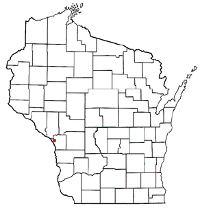
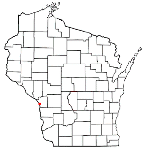
La Crosse County is a county located in the U.S. state of Wisconsin. At the 2020 census, the population was 120,784. Its county seat is La Crosse. La Crosse County is included in the La Crosse-Onalaska, WI-MN Metropolitan Statistical Area with a population of 170,341 and is the most populous county on Wisconsin's western border.

<span class="mw-page-title-main">Clark County, Wisconsin</span> County in Wisconsin, United States

Clark County is a county in the U.S. state of Wisconsin. As of the 2020 census, the population was 34,659. Its county seat is Neillsville.

<span class="mw-page-title-main">Hokah, Minnesota</span> City in Minnesota, United States

Hokah is a city in Houston County, Minnesota, United States. The population was 580 at the 2010 census. Hokah is located near the confluence of the Root and Mississippi rivers, opposite La Crosse, Wisconsin.

<span class="mw-page-title-main">Eaton, Clark County, Wisconsin</span> Town in Wisconsin, United States

Eaton is a town in Clark County in the U.S. state of Wisconsin. The population was 712 at the 2010 census.

<span class="mw-page-title-main">Hixon, Wisconsin</span> Town in Wisconsin, United States

Hixon is a town in Clark County in the U.S. state of Wisconsin. The population was 740 at the 2000 census. Most of the village of Withee, most of the city of Owen, and the ghost town of Clark are located in Hixon.

<span class="mw-page-title-main">Longwood, Wisconsin</span> Town in Wisconsin, United States

Longwood is a town in Clark County in the U.S. state of Wisconsin. The population was 698 at the 2000 census.

<span class="mw-page-title-main">Warner, Wisconsin</span> Town in Wisconsin, United States

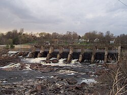
Warner is a town in Clark County in the U.S. state of Wisconsin. As of the 2000 census, the town had a total population of 627. Hemlock, now a ghost town in Warner, was once a little mill town that grew around a dam below the confluence of the Black and Popple rivers.

<span class="mw-page-title-main">Brice Prairie, Wisconsin</span> Census-designated place in Wisconsin, United States

Brice Prairie is a census-designated place (CDP) in La Crosse County, Wisconsin, United States. The population was 1,887 at the 2010 census. Brice Prairie is located in the Town of Onalaska.

<span class="mw-page-title-main">Campbell, Wisconsin</span> Town in Wisconsin, United States

Campbell is a town in the middle of the Mississippi River in La Crosse County, Wisconsin, United States. It is part of the La Crosse, Wisconsin Metropolitan Statistical Area. The population was 4,284 as of the 2020 Census.

<span class="mw-page-title-main">French Island, Wisconsin</span> Census-designated place in Wisconsin, United States

French Island is a census-designated place (CDP) in La Crosse County, Wisconsin, United States. The population was 4,207 at the 2010 census. It lies on an island of the same name, though they are not coextensive; a portion of the island is part of the city of La Crosse. All of the island is part of the La Crosse Metropolitan Statistical Area. French Island is part of the town of Campbell and contains all of its population, because the balance of Campbell is uninhabited.

<span class="mw-page-title-main">Little Black, Wisconsin</span> Town in Wisconsin, United States

Little Black is a town located in Taylor County, Wisconsin. The village of Stetsonville lies partly in the town, and the hamlet of Little Black. As of the 2000 census, the town had a total population of 1,148.

<span class="mw-page-title-main">Maplehurst, Wisconsin</span> Town in Wisconsin, United States

Maplehurst is a town in Taylor County, Wisconsin, United States. The population was 359 at the 2000 census.

<span class="mw-page-title-main">Thorp, Wisconsin</span> City in Wisconsin, United States

Thorp is a city in Clark County in the U.S. state of Wisconsin. The population was 1,621 at the 2010 census. The city is located partially within the Town of Thorp and partially within the Town of Withee.

<span class="mw-page-title-main">Onalaska, Wisconsin</span> City in the United States

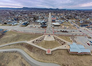
Onalaska is a city in La Crosse County, Wisconsin, United States. The population was 18,803 at the 2020 census. It borders the larger La Crosse, Wisconsin, and is a part of the La Crosse-Onalaska, WI-MN Metropolitan Area.

<span class="mw-page-title-main">Wisconsin River</span> Major river in Wisconsin, United States

The Wisconsin River is a tributary of the Mississippi River in the U.S. state of Wisconsin. At approximately 430 miles long, it is the state's longest river. The river's name was first recorded in 1673 by Jacques Marquette as "Meskousing" from his Indian guides - most likely Miami for "river running through a red place."

<span class="mw-page-title-main">Jump River</span>

The Jump River is a small rocky river in north-central Wisconsin. In the late 19th century it was used to drive logs down to the Chippewa River. Today it is recreational, rambling through woods and farmlands, used mostly by fishermen and paddlers.

<span class="mw-page-title-main">Chippewa River (Wisconsin)</span> River in Wisconsin, United States

The Chippewa River in Wisconsin flows approximately 183 miles (294 km) through west-central and northwestern Wisconsin. It was once navigable for approximately 50 miles (80 km) of its length, from the Mississippi River, by Durand, northeast to Eau Claire. Its catchment defines a portion of the northern boundary of the Driftless Area. The river is easily accessible for bikers and pleasure seekers via the Chippewa River State Trail, which follows the river from Eau Claire to Durand.

<span class="mw-page-title-main">Black River (Gogebic County)</span> River in Michigan, United States

The Black River is a 41.1-mile-long (66.1 km) river on the Upper Peninsula of the U.S. state of Michigan, flowing mostly in Gogebic County into Lake Superior at 46°40′03″N90°02′57″W. Its source at 46°18′54″N90°01′15″W is a boreal wetland on the border with Iron County, Wisconsin. The northern section of the river, 14 miles (23 km) within the boundaries of the Ottawa National Forest, was designated a National Wild and Scenic River in 1992.

<span class="mw-page-title-main">Lake Onalaska</span> Reservoir

Lake Onalaska is a reservoir located on the Black River and Mississippi River between Wisconsin, and Minnesota. It is approximately 4 miles (6.4 km) across, and is the widest point on the Mississippi River. Located in La Crosse County in the state of Wisconsin, its latitude and longitude are 43°52′01″N091°18′26″W. The lake is 7,688 acres (31.11 km2) and is shored by the city from which its name came from: Onalaska, Wisconsin. It sits at an altitude of 633 feet and is 43 feet (13 m) deep at its deepest.

<span class="mw-page-title-main">Great River Trail</span>

The Great River State Trail is a 24-mile (39 km) rail trail between Onalaska and Marshland, Wisconsin. It is designed for foot, bicycle, equestrian or light motorized traffic. It is designated as a multiuse trail, offering recreational access to the routes, and is open to the public.

References

  1. 1 2 3 "Black River". Geographic Names Information System . United States Geological Survey, United States Department of the Interior.
  2. "The Black River Basin". dnr.wisconsin.gov. Wisconsin Department of Natural Resources. Retrieved 12 August 2022.
  3. 1 2 U.S. Geological Survey. National Hydrography Dataset high-resolution flowline data. The National Map Archived 2012-03-29 at the Wayback Machine , accessed October 5, 2012
  4. Black River – WDNR Archived October 10, 2007, at the Wayback Machine
  5. "East Fork Black River". Geographic Names Information System . United States Geological Survey, United States Department of the Interior.
  6. "Little Black River". Geographic Names Information System . United States Geological Survey, United States Department of the Interior.
  7. "West Branch Little Black River". Geographic Names Information System . United States Geological Survey, United States Department of the Interior.
  8. U.S. Geological Survey Geographic Names Information System: East Branch Little Black River
  9. Schmirler, A. A. A., "Wisconsin's Lost Missionary: The Mystery of Father Rene Menard", The Wisconsin Magazine of History, Volume 45, number 2, winter, 1961-1962.
  10. Grossman, Zoltan; Marily B. Crews-Nelson; Laura Exner; Michael Gallagher; Amelia R. Janes; Jeffry Maas (1998). Wisconsin's Past and Present - A Historical Atlas. Madison, Wisconsin: The University of Wisconsin Press. pp. 9–11. ISBN   029915940X.
  11. Finley, Robert W.,"Finley's Presettlement Vegetation" Archived 2013-12-05 at the Wayback Machine , 1976, University of Wisconsin.
  12. Vogel, John N. (Spring 1983). "The Round Lake Logging Dam: A Survivor of Wisconsin's Log-driving Days". Wisconsin Magazine of History. 66 (3): 170–191. Retrieved 2011-09-21.
  13. 1 2 3 Fries, Robert F. (1951). Empire in Pine - The Story of Lumbering in Wisconsin 1830-1900 . Madison: The State Historical Society of Wisconsin. pp.  20, 55.
  14. 1 2 Draper, Fred W. (1936-01-23). "Early Clark and Jackson Counties History - An Unwritten Page". Neillsville Press. Retrieved 2013-12-10.
  15. blackriverfalls.com - Home Archived February 9, 2008, at the Wayback Machine
  16. Patricia Marks (June 1979). "National Register of Historic Places Multiple Property Documentation: Van Loon Wildlife Area Truss Bridge TR". National Park Service . Retrieved January 13, 2017.