French Island, Wisconsin

Last updated

French Island, Wisconsin
WIMap-doton-French Island.png
Location of French Island, Wisconsin
Coordinates: 43°51′48″N91°15′41″W / 43.86333°N 91.26139°W / 43.86333; -91.26139 [1]
Country United States
State Wisconsin
County La Crosse
Town Campbell
Area
[2]
  Total2.52 sq mi (6.53 km2)
  Land2.02 sq mi (5.24 km2)
  Water0.50 sq mi (1.29 km2)
Elevation
[1]
653 ft (199 m)
Population
 (2010) [3]
  Total4,207
  Density2,081/sq mi (803.3/km2)
Time zone UTC-6 (Central (CST))
  Summer (DST) UTC-5 (CDT)
ZIP Code
54603 (La Crosse)
Area code 608
FIPS code 55-27875 [4]
GNIS feature ID2393013 [1]

French Island is a census-designated place (CDP) in La Crosse County, Wisconsin, United States. The population was 4,207 at the 2010 census. [3] It lies on an island of the same name, though they are not coextensive; a portion of the island is part of the city of La Crosse. All of the island is part of the La Crosse Metropolitan Statistical Area. French Island is part of the town of Campbell and contains all of its population, because the balance of Campbell is uninhabited.

Contents

Geography

French Island is located in western La Crosse County. It is surrounded by waterways connected to the Mississippi River: French Slough, French Lake, and Lake Onalaska to the west, and the Black River and Richmond Bay to the east. Two parts of the dam forming Lake Onalaska on the Mississippi connect to French Island: one at the head of French Lake, and the other impounding the Black River.

The neighborhood of West La Crosse is in the southern part of the CDP.

According to the United States Census Bureau, the French Island CDP has a total area of 2.520 square miles (6.527 square kilometres), of which 2.022 square miles (5.237 square kilometres) are land and 0.498 square miles (1.290 square kilometres), or 19.76%, are water. [2] The entire island's land area is 4.549 square miles (11.781 square kilometres).

Demographics

Historical population
YearPop.±%
2000 4,410    
2010 4,207−4.6%

As of the census [4] of 2000, there were 4,410 people, 1,754 households, and 1,266 families residing in the CDP. The population density was 2,207.6 people per square mile (851.4/km2). There were 1,823 housing units at an average density of 912.6/sq mi (351.9/km2). The racial makeup of the CDP was 96.49% White, 0.52% African American, 0.52% Native American, 1.09% Asian, 0.02% Pacific Islander, 0.27% from other races, and 1.09% from two or more races. Hispanic or Latino of any race were 0.68% of the population.

There were 1,754 households, out of which 31.4% had children under the age of 18 living with them, 60.7% were married couples living together, 7.8% had a female householder with no husband present, and 27.8% were non-families. 21.6% of all households were made up of individuals, and 6.6% had someone living alone who was 65 years of age or older. The average household size was 2.51 and the average family size was 2.93.

In the CDP, the population was spread out, with 23.8% under the age of 18, 8.4% from 18 to 24, 27.3% from 25 to 44, 28.9% from 45 to 64, and 11.6% who were 65 years of age or older. The median age was 40 years. For every 100 females, there were 101.1 males. For every 100 females age 18 and over, there were 100.2 males.

The median income for a household in the CDP was $44,736, and the median income for a family was $55,439. Males had a median income of $37,165 versus $25,267 for females. The per capita income for the CDP was $20,741. About 4.6% of families and 5.1% of the population were below the poverty line, including 8.0% of those under age 18 and 1.5% of those age 65 or over.

Economy

The French Island Generating Plant is located at the south end of French Island, within the La Crosse city limits.

Cargill grain dock Cargill dock 01.jpg
Cargill grain dock
French Island incinerator French Island incinerator.jpg
French Island incinerator

Transportation

The island is accessible from the mainland by automobile, by way of the I-90 Mississippi River Bridge and from North La Crosse via the Clinton Street Bridge at the extreme southern end of the island. There is another bridge about four miles downstream, the La Crosse West Channel Bridge, which connects Barron Island to La Crescent, Minnesota.

La Crosse MTU provides bus service from French Island to North La Crosse.

The La Crosse Regional Airport occupies the northern part of French Island and is within the La Crosse city limits.

French Island, Wisconsin 2.jpg
West side of French Island from Lake Onalaska

Notable people

See also

Related Research Articles

<span class="mw-page-title-main">La Crosse County, Wisconsin</span> County in Wisconsin, United States

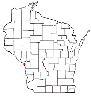
La Crosse County is a county located in the U.S. state of Wisconsin. At the 2020 census, the population was 120,784. Its county seat is La Crosse. La Crosse County is included in the La Crosse-Onalaska, WI-MN Metropolitan Statistical Area with a population of 139,627 and is the most populous county on Wisconsin's western border.

<span class="mw-page-title-main">Houston County, Minnesota</span> County in Minnesota, United States

Houston County is a county in the U.S. state of Minnesota. At the 2020 census, the population was 18,843. Its county seat is Caledonia.

Rosewood Heights is an unincorporated community and census-designated place (CDP) in Madison County, Illinois, United States. The population was 3,971 at the 2020 census. It is part of the Metro East region of the Greater St. Louis metropolitan area.

<span class="mw-page-title-main">Hokah, Minnesota</span> City in Minnesota, United States

Hokah is a city in Houston County, Minnesota, United States. The population was 580 at the 2010 census. Hokah is located near the confluence of the Root and Mississippi rivers, opposite La Crosse, Wisconsin, and is part of the La Crosse metropolitan area.

<span class="mw-page-title-main">Dakota, Minnesota</span> City in Minnesota, United States

Dakota is a city in Winona County, Minnesota, United States. The population was 295 at the 2020 census.

<span class="mw-page-title-main">Brice Prairie, Wisconsin</span> Census-designated place in Wisconsin, United States

Brice Prairie is a census-designated place (CDP) in La Crosse County, Wisconsin, United States. The population was 1,887 at the 2010 census. Brice Prairie is located in the Town of Onalaska.

<span class="mw-page-title-main">Campbell, Wisconsin</span> Town in Wisconsin, United States

Campbell is a town in the middle of the Mississippi River in La Crosse County, Wisconsin, United States. It is part of the La Crosse, Wisconsin Metropolitan Statistical Area. The population was 4,358 as of the 2010 Census.

<span class="mw-page-title-main">Farmington, La Crosse County, Wisconsin</span> Town in Wisconsin, United States

Farmington is a town in La Crosse County, Wisconsin, United States. The population was 2,061 at the 2010 census, up from 1,733 at the 2000 census. It is part of the La Crosse Metropolitan Statistical Area. The unincorporated communities of Burr Oak, Mindoro, and Stevenstown are in the town.

<span class="mw-page-title-main">La Crosse, Wisconsin</span> City in Wisconsin, United States

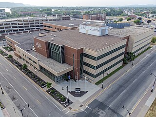
La Crosse is a city in the U.S. state of Wisconsin and the county seat of La Crosse County. Positioned alongside the Mississippi River, La Crosse is the largest city on Wisconsin's western border. La Crosse's population as of the 2020 census was 52,680. The city forms the core of and is the principal city in the La Crosse–Onalaska Metropolitan Area, which includes all of La Crosse County and Houston County, Minnesota, with a population of 139,627.

<span class="mw-page-title-main">West Salem, Wisconsin</span> Village in Wisconsin, United States

West Salem is a village in La Crosse County, Wisconsin, United States, along the La Crosse River. It is part of the La Crosse-Onalaska, WI-MN Metropolitan Statistical Area. The population was 4,799 as of the 2010 Census.

<span class="mw-page-title-main">Bohners Lake, Wisconsin</span> CDP in Wisconsin, United States

Bohners Lake is a census-designated place (CDP) in Racine County, Wisconsin, United States. Its first syllable is pronounced as in "bone". The population of the CDP was 2,374 at the 2020 census. It is politically part of the Town of Burlington, together with Browns Lake, Wisconsin. There has been discussion of incorporating Bohners Lake as a village to prevent annexation by the City of Burlington. It was named for Antony Bohner, a French immigrant who established a resort on the lake of the same name.

<span class="mw-page-title-main">Wind Lake, Wisconsin</span> Place in Wisconsin, United States

Wind Lake is a census-designated place (CDP) in Racine County, Wisconsin, United States. The population was 5,355 at the 2020 census. Wind Lake is in the town of Norway.

<span class="mw-page-title-main">Lake Delton, Wisconsin</span> Village in Wisconsin, United States

Lake Delton is a village located on the Wisconsin River in Sauk County, Wisconsin, United States. The population was 3,501 at the 2020 census. Lake Delton, along with the nearby Wisconsin Dells, is a resort area and a center for tourism in the upper Midwest. Lake Delton is included in the Baraboo Micropolitan Area which comprises part of the larger Madison Combined Statistical Area.

<span class="mw-page-title-main">La Crescent, Minnesota</span> City in Minnesota, United States

La Crescent is a city in Houston and Winona counties in the U.S. state of Minnesota. The population was 5,276 at the 2020 census.

<span class="mw-page-title-main">Lake Wisconsin, Wisconsin</span> CDP in Wisconsin, United States

Lake Wisconsin is a census-designated place (CDP) in Columbia and Sauk counties, in the towns of Lodi and Merrimac, in Wisconsin, United States. The population was 4,189 at the 2010 census.

<span class="mw-page-title-main">Prairie du Chien, Wisconsin</span> Place in City

Prairie du Chien is a city in and the county seat of Crawford County, Wisconsin, United States. The population was 5,506 at the 2020 census. Its ZIP Code is 53821.

<span class="mw-page-title-main">Bangor, Wisconsin</span> Village in Wisconsin, United States

Bangor is a village in La Crosse County, Wisconsin, United States, along the La Crosse River. It is part of the La Crosse-Onalaska, WI-MN Metropolitan Statistical Area. The population was 1,437 as of the 2020 Census. The village is located partially within the Town of Bangor.

<span class="mw-page-title-main">Onalaska (town), Wisconsin</span> Town in the United States

Onalaska is a town in La Crosse County, Wisconsin, United States. The population was 5,623 at the 2010 census. The City of Onalaska borders the town, as does the village of Holmen. The CDP of Brice Prairie is located in the western part of the Town of Onalaska. The unincorporated community of Midway is also located in the town. Onalaska (town), Wisconsin is part of the La Crosse, Wisconsin Metropolitan Statistical Area.

<span class="mw-page-title-main">Onalaska, Wisconsin</span> City in the United States

Onalaska is a city in La Crosse County, Wisconsin, United States. The population was 18,803 at the 2020 census. It borders the larger La Crosse, Wisconsin, and is a part of the La Crosse-Onalaska, WI-MN Metropolitan Area.

Newport is a census-designated place (CDP) consisting of the main area of settlement within the town of Newport in Penobscot County, Maine, United States. The population of the CDP was 1,776 at the 2010 census.

References

  1. 1 2 3 U.S. Geological Survey Geographic Names Information System: French Island, Wisconsin
  2. 1 2 "2020 U.S. Gazetteer Files – Wisconsin". United States Census Bureau. Retrieved March 18, 2021.
  3. 1 2 "Total Population: 2010 Census DEC Summary File 1 (P1), French Island CDP, Wisconsin". data.census.gov. U.S. Census Bureau. Retrieved March 18, 2021.
  4. 1 2 "U.S. Census website". United States Census Bureau . Retrieved January 31, 2008.

{authority control}}