
La Crosse County is a county located in the U.S. state of Wisconsin. At the 2010 census, the population was 114,638. The 2019 estimate placed the county's population at 118,016. Its county seat is La Crosse.

Hokah is a city in Houston County, Minnesota, United States. The population was 580 at the 2010 census. Hokah is located near the confluence of the Root and Mississippi rivers, opposite La Crosse, Wisconsin, and is part of the La Crosse metropolitan area.

Barre is a town in La Crosse County, Wisconsin, United States. The population was 1,234 at the 2010 census. It is part of the La Crosse, Wisconsin Metropolitan Statistical Area. The town hall is in the unincorporated community of Barre Mills.
Brice Prairie is a census-designated place (CDP) in La Crosse County, Wisconsin, United States. The population was 1,887 at the 2010 census. Brice Prairie is located in the town of Onalaska.
French Island is a census-designated place (CDP) in La Crosse County, Wisconsin, United States. The population was 4,207 at the 2010 census. It lies on an island of the same name, though they are not coextensive; a portion of the island is part of the city of La Crosse. All of the island is part of the La Crosse Metropolitan Statistical Area. French Island is part of the town of Campbell and contains all of its population, because the balance of Campbell is uninhabited.
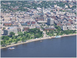
La Crosse is a city in the U.S. state of Wisconsin and the county seat of La Crosse County. Positioned alongside the Mississippi River, La Crosse is the largest city on Wisconsin's western border. La Crosse's estimated population in 2019 was 51,227. The city forms the core of and is the principal city in the La Crosse Metropolitan Area, which includes all of La Crosse County and Houston County, Minnesota, for a population of 135,298.

Medary is a town in La Crosse County, Wisconsin, United States. The population was 1,461 at the 2010 census. It is part of the La Crosse, Wisconsin Metropolitan Statistical Area. The unincorporated community of Medary is located in the town.

Shelby is a town in La Crosse County, Wisconsin, United States. It is part of the La Crosse, Wisconsin Metropolitan Statistical Area. The population was 4,715 at the 2010 census. The unincorporated community of Shelby is located in the town.

West Salem is a village in La Crosse County, Wisconsin, United States, along the La Crosse River. It is part of the La Crosse-Onalaska, WI-MN Metropolitan Statistical Area. The population was 4,799 as of the 2010 Census.

The La Crosse Center is a multi-purpose arena in downtown La Crosse, Wisconsin, built in 1980. The arena can seat between 5,000 and 7,500, depending on the type of event.

The Elroy-Sparta State Trail is a 32.5-mile (52.3 km) Wisconsin State rail trail between Elroy and Sparta, Wisconsin. Considered to be the first rail trail when it opened in 1967, it was designed for foot, bicycle, equestrian and light motorized traffic. Designated a multi-use trail, it offers recreational access to the routes and is open to the public. The trail is part of the larger Wisconsin bike trail system operated by the state of Wisconsin. It passes through rural scenery and three tunnels. It is one of six connecting trails in west-central Wisconsin. It was added to the Rails-to-Trails Conservancy hall of Fame in September 2008. It is one of the most popular trails in Wisconsin.
The La Crosse River is a 61.3-mile-long (98.7 km) tributary of the Mississippi River in southwestern Wisconsin in the United States.

The Black River is a river in west-central Wisconsin and tributary of the Mississippi River. The river is approximately 190 miles (310 km) long. During the 19th century, pine logs were rafted down the Black, heading for sawmills at La Crosse and points beyond.

Mindoro is an unincorporated community in La Crosse County, Wisconsin, United States, in the town of Farmington. It is part of the La Crosse, Wisconsin Metropolitan Statistical Area.
Stevenstown is a small unincorporated community in La Crosse County, Wisconsin, United States, in the town of Farmington. It is part of the La Crosse, Wisconsin Metropolitan Statistical Area.

Copeland Park, also referred to as "The Lumber Yard", is a stadium in La Crosse, Wisconsin, USA. It is primarily used for baseball and is the home field of the La Crosse Loggers baseball team. The current stadium was built in 2003, although a substantially smaller baseball diamond existed at the site before the construction of the new ballpark. At the time of its construction, the stadium held approximately 2,000 people. However, the success of the Loggers prompted expansions to the grandstand, bringing the capacity to its current 3,550 people. The field dimensions are 325 ft. to left field, 365 ft. to center, and 315 ft. to right.
La Crosse Public Library is the public library system in La Crosse, Wisconsin.

Coulee Experimental State Forest is a state forest located in La Crosse County, Wisconsin, United States. It is administered by the Wisconsin Department of Natural Resources. The hilly terrain within the state forest is an excellent representation of Wisconsin's portion of the Driftless Area.
Middle Ridge is an unincorporated community in the town of Washington in La Crosse County, Wisconsin, United States.
The La Crosse River State Trail is a 22-mile (35 km) rail trail between Sparta and Onalaska, Wisconsin. It is designed for foot, bicycle, equestrian or light motorized traffic. It is designated as a multiuse trail, offering recreational access to the routes, and is open to the public.


