Chippewa County, Wisconsin

Last updated

Chippewa County
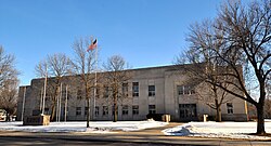
Chippewa County Courthouse, Wisconsin.JPG
Chippewa County Courthouse, February 2015
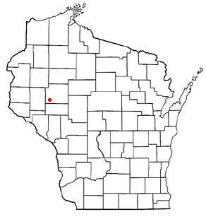
Map of Wisconsin highlighting Chippewa County.svg
Location within the U.S. state of Wisconsin
Wisconsin in United States.svg
Wisconsin's location within the U.S.
Coordinates: 45°04′N91°17′W / 45.07°N 91.28°W / 45.07; -91.28
CountryFlag of the United States.svg United States
StateFlag of Wisconsin.svg  Wisconsin
Founded1853
Named for Ojibwa
Seat Chippewa Falls
Largest cityChippewa Falls
Area
  Total1,041 sq mi (2,700 km2)
  Land1,008 sq mi (2,610 km2)
  Water33 sq mi (90 km2)  3.2%
Population
 (2020) [1]
  Total66,297
  Density65.7/sq mi (25.4/km2)
Time zone UTC−6 (Central)
  Summer (DST) UTC−5 (CDT)
Congressional districts 3rd, 7th
Website www.co.chippewa.wi.us

Chippewa County is a county located in the U.S. state of Wisconsin. It is named for the historic Chippewa people, also known as the Ojibwe, who long controlled this territory. As of the 2020 census, the population was 66,297. [1] Its county seat is Chippewa Falls. [2] The county was founded in 1845 from Crawford County, [3] then in the Wisconsin Territory, and organized in 1853. [4] [5] [6]

Contents

Chippewa County is included in the Eau Claire, WI Metropolitan Statistical Area as well as the Eau Claire-Menomonie, WI Combined Statistical Area.

Geography

According to the U.S. Census Bureau, the county has a total area of 1,041 square miles (2,700 km2), of which 1,008 square miles (2,610 km2) is land and 33 square miles (85 km2) (3.2%) is water. [7]

October view of Picnic Lake from the Ice Age Trail west of Cornell Ice Age Trail Picnic Lake.jpg
October view of Picnic Lake from the Ice Age Trail west of Cornell

Parts of northern Chippewa county are covered with choppy hills dimpled by kettle lakes and bogsthe terminal moraine left by the last glacier. [8] The Ice Age Trail threads through some of this country, providing public foot-access to these unusual landforms. [9]

Adjacent counties

Major highways

Railroads

Buses

Airports

Demographics

Historical population
CensusPop.
1850 615
1860 1,895208.1%
1870 8,311338.6%
1880 15,49186.4%
1890 25,14362.3%
1900 33,03731.4%
1910 32,103−2.8%
1920 36,48213.6%
1930 37,3422.4%
1940 40,7039.0%
1950 42,8395.2%
1960 45,0965.3%
1970 47,7175.8%
1980 52,1279.2%
1990 52,3600.4%
2000 55,1955.4%
2010 62,41513.1%
2020 66,2976.2%
U.S. Decennial Census [10]
1790–1960 [11] 1900–1990 [12]
1990–2000 [13] 2010 [14] 2020 [1]

2020 census

As of the census of 2020, [1] the population was 66,297. The population density was 65.7 inhabitants per square mile (25.4/km2). There were 28,688 housing units at an average density of 28.5 per square mile (11.0/km2). The racial makeup of the county was 91.8% White, 1.6% Black or African American, 1.5% Asian, 0.5% Native American, 0.6% from other races, and 4.0% from two or more races. Ethnically, the population was 1.9% Hispanic or Latino of any race.

2000 census

2000 Census Age Pyramid for Chippewa County USA Chippewa County, Wisconsin age pyramid.svg
2000 Census Age Pyramid for Chippewa County

As of the census [15] of 2000, there were 55,195 people, 21,356 households, and 15,013 families residing in the county. The population density was 55 people per square mile (21/km2). There were 22,821 housing units at an average density of 23 per square mile (9/km2). The racial makeup of the county was 97.85% White, 0.16% Black or African American, 0.32% Native American, 0.89% Asian, 0.01% Pacific Islander, 0.17% from other races, and 0.60% from two or more races. 0.52% of the population were Hispanic or Latino of any race. 44.1% were of German, 15.8% Norwegian and 5.8% Irish ancestry.

There were 21,356 households, out of which 33.70% had children under the age of 18 living with them, 58.30% were married couples living together, 8.00% had a female householder with no husband present, and 29.70% were non-families. 24.70% of all households were made up of individuals, and 11.00% had someone living alone who was 65 years of age or older. The average household size was 2.53 and the average family size was 3.03.

In the county, the population was spread out, with 26.50% under the age of 18, 7.70% from 18 to 24, 28.20% from 25 to 44, 23.10% from 45 to 64, and 14.60% who were 65 years of age or older. The median age was 38 years. For every 100 females, there were 99.10 males. For every 100 females age 18 and over, there were 96.00 males.

In 2017, there were 624 births, giving a general fertility rate of 59.7 births per 1000 women aged 15–44, the 26th lowest rate out of all 72 Wisconsin counties. [16] Additionally, there were fewer than five reported induced abortions performed on women of Chippewa County residence in 2017. [17]

Economy

The largest employers in Chippewa County are: [18]

1TTM Advanced Circuits
2Chippewa Falls Public Schools
3Saint Joseph's Hospital
4 Wisconsin Department of Corrections
5 Wal-Mart
6 Mason Companies Inc
7Chippewa County
8 Mayo Health System
9 Silicon Graphics International
10Cooperative Educational Service Agency #10

Library

The University of Wisconsin-Eau Claire's Special Collections and Archives, located on the fifth floor of McIntyre Library, houses an extensive collection of public records, books and collections relating to Chippewa County. In addition to vital records (birth and marriage) dating to 1907, there are also naturalization records, census records, and civil and circuit court records. These resources are very popular with local genealogists.

Within the local history collection, there are books about immigration to the region, logging, church and cemetery records, reminiscences by local residents, and a number of histories and biographies compiled by local historians.

Special Collections and Archives also houses numerous archives files which relate to Chippewa County. There are many collections which pertain to logging, the railway industry and agriculture.

The University of Wisconsin-Eau Claire's Special Collections and Archives also includes information for Buffalo, Clark, Eau Claire, Rusk and Taylor counties.

Communities

A farm in Chippewa county ChippewaFallsWI.jpg
A farm in Chippewa county

Cities

Villages

Towns

Census-designated places

Other unincorporated communities

Politics

At the presidential level, Chippewa County leans Republican; however, Barack Obama won the county in 2008. In 2020, Donald Trump received 59.3 percent of the vote, the best result for a Republican since Dwight Eisenhower in 1956.

United States presidential election results for Chippewa County, Wisconsin [19]
Year Republican Democratic Third party
No.%No.%No.%
2020 21,31759.32%13,98338.91%6381.78%
2016 17,91656.75%11,88737.66%1,7655.59%
2012 15,32249.53%15,23749.26%3731.21%
2008 13,49244.63%16,23953.72%5001.65%
2004 15,45050.62%14,75148.33%3231.06%
2000 12,83549.04%12,10246.24%1,2364.72%
1996 7,52035.59%9,64745.65%3,96418.76%
1992 8,21532.56%10,48741.57%6,52825.87%
1988 9,75745.69%11,44753.61%1500.70%
1984 10,98651.45%10,20247.78%1630.76%
1980 10,53148.06%9,83644.89%1,5457.05%
1976 8,13740.50%11,53857.42%4182.08%
1972 8,45149.35%8,21047.95%4622.70%
1968 7,77247.38%7,33544.72%1,2967.90%
1964 6,27736.46%10,91163.38%260.15%
1960 8,69046.95%9,79352.90%280.15%
1956 9,78159.42%6,61740.20%630.38%
1952 11,42964.01%6,38035.73%450.25%
1948 6,14643.58%7,70254.62%2541.80%
1944 7,69153.59%6,56745.76%930.65%
1940 8,78154.30%7,25044.83%1400.87%
1936 5,76038.93%7,85453.08%1,1827.99%
1932 4,79235.71%8,44562.92%1841.37%
1928 7,51455.41%5,98544.13%620.46%
1924 5,13541.72%5604.55%6,61353.73%
1920 6,75082.57%1,10313.49%3223.94%
1916 3,32458.15%2,23339.07%1592.78%
1912 1,73633.93%2,02839.63%1,35326.44%
1908 3,52659.07%2,20336.91%2404.02%
1904 3,74466.49%1,67029.66%2173.85%
1900 4,21561.88%2,44635.91%1512.22%
1896 3,60154.09%2,92944.00%1271.91%
1892 1,97539.48%2,53050.57%4989.95%


See also

Related Research Articles

<span class="mw-page-title-main">Sawyer County, Wisconsin</span> County in Wisconsin, United States

Sawyer County is a county in the U.S. state of Wisconsin. As of the 2020 census, the population was 18,074. Its county seat is Hayward. The county partly overlaps with the reservation of the Lac Courte Oreilles Band of Lake Superior Chippewa Indians.

<span class="mw-page-title-main">Price County, Wisconsin</span> County in Wisconsin, United States

Price County is a county in the U.S. state of Wisconsin. As of the 2020 census, the population was 14,054. Its county seat is Phillips.

<span class="mw-page-title-main">Portage County, Wisconsin</span> County in Wisconsin, United States

Portage County is a county in the U.S. state of Wisconsin. As of the 2020 census, the population was 70,377. Its county seat is Stevens Point.

<span class="mw-page-title-main">Marathon County, Wisconsin</span> County in Wisconsin, United States

Marathon County is a county located in the U.S. state of Wisconsin. As of the 2020 census, the population was 138,013. Marathon County's seat is Wausau. It was founded in 1850, created from a portion of Portage County. At that time the county stretched to the northern border with the upper Michigan peninsula. It is named after the battlefield at Marathon, Greece.

<span class="mw-page-title-main">Jackson County, Wisconsin</span> County in Wisconsin, United States

Jackson County is a county located in the U.S. state of Wisconsin. As of the 2020 census, the population was 21,145. Its county seat is Black River Falls. Jackson County was formed from Crawford County in 1853. It was named for President Andrew Jackson.

<span class="mw-page-title-main">Eau Claire County, Wisconsin</span> County in Wisconsin, United States

Eau Claire County is a county located in the U.S. state of Wisconsin. As of the 2020 census, the population was 105,710. Its county seat is Eau Claire. The county took its name from the Eau Claire River.

<span class="mw-page-title-main">Dunn County, Wisconsin</span> County in Wisconsin, United States

Dunn County is a county in the U.S. state of Wisconsin. As of the 2020 census, the population was 45,440. Its county seat is Menomonie. Dunn County comprises the Menomonie Micropolitan Statistical Area and is included in the Eau Claire-Menomonie, WI Combined Statistical Area.

<span class="mw-page-title-main">Clark County, Wisconsin</span> County in Wisconsin, United States

Clark County is a county in the U.S. state of Wisconsin. As of the 2020 census, the population was 34,659. Its county seat is Neillsville.

<span class="mw-page-title-main">Buffalo County, Wisconsin</span> County in Wisconsin, United States

Buffalo County is a county located in the U.S. state of Wisconsin. As of the 2020 census, the population was 13,317. Its county seat is Alma. The county was created in 1853 and organized the following year.

<span class="mw-page-title-main">Bayfield County, Wisconsin</span> County in Wisconsin, United States

Bayfield County is the northernmost county in the U.S. state of Wisconsin. As of the 2020 census, its population is 16,220. Its county seat is Washburn. The county was created in 1845 and organized in 1850. The Red Cliff Band of Lake Superior Chippewa has a reservation in Bayfield County and is the county's largest employer.

<span class="mw-page-title-main">Webster, Burnett County, Wisconsin</span> Village in Wisconsin, United States

Webster is a village in Burnett County in the U.S. state of Wisconsin. The population was 653 at the 2010 census. It is along Wisconsin Highway 35.

<span class="mw-page-title-main">Chippewa Falls, Wisconsin</span> City in Wisconsin, United States

Chippewa Falls is a city located on the Chippewa River in Chippewa County in the northwestern part of the U.S. state of Wisconsin. The population was 14,731 in the 2020 census. Incorporated as a city in 1869, it is the county seat of Chippewa County.

<span class="mw-page-title-main">Stanley, Wisconsin</span> City in Wisconsin, United States

Stanley is a city in Chippewa and Clark counties in the U.S. state of Wisconsin. The population was 3,608 at the 2010 census. Of this, 3,602 were in Chippewa County, and 6 in Clark County.
<span class="mw-page-title-main">Wheaton, Wisconsin</span> Town in Wisconsin, United States

Wheaton is a town in Chippewa County in the U.S. state of Wisconsin. The population was 2,701 at the 2010 census, up from 2,366 at the 2000 census. The unincorporated communities of Old Albertville and Pine Grove are located in the town.

<span class="mw-page-title-main">Altoona, Wisconsin</span> City in Wisconsin, United States

Altoona is a city in Eau Claire County, Wisconsin, United States. The population was 8,292 at the 2020 census with an estimated population in 2021 of 8,817. The city is a railroad terminal on the Union Pacific Railroad.

<span class="mw-page-title-main">Ackley, Wisconsin</span> Town in Wisconsin, United States

Ackley is a town in Langlade County, Wisconsin, United States. The population was 524 at the 2010 census. The town was founded March 4, 1879. It was named after William L. Ackley, who established a logging camp in the area.

<span class="mw-page-title-main">Schofield, Wisconsin</span> City in Wisconsin, United States

Schofield is a city in Marathon County, Wisconsin, United States. It is part of the Wausau, Wisconsin Metropolitan Statistical Area. The population was 2,169 at the 2010 census. The city was named for William Scholfield, who came to the area in the 1851 to open a sawmill. The city has since dropped the "L" from its name.

<span class="mw-page-title-main">Eau Claire, Wisconsin</span> City in Wisconsin, United States

Eau Claire is a city mostly located in Eau Claire County, Wisconsin, being the county seat of Eau Claire County, but with a small portion in Chippewa County, Wisconsin. The city had a population of 69,421 in 2020, making it the state's eighth-largest city. Eau Claire is the principal city of the Eau Claire, Wisconsin Metropolitan Statistical Area, locally known as the Chippewa Valley, and is also part of the larger Eau Claire-Menomonie Combined Statistical Area.

<span class="mw-page-title-main">Turtle Lake, Wisconsin</span> Village in Wisconsin, United States

Turtle Lake is a village in Barron and Polk counties in the U.S. state of Wisconsin. The population was 1,064 at the 2010 census. Of this, 972 were in Barron County, and 93 were in Polk County. The village is located between the towns of Almena, in Barron County, and Beaver, in Polk County.

<span class="mw-page-title-main">Lake Hallie, Wisconsin</span> Village in Wisconsin, United States

Lake Hallie is a village in Chippewa County, Wisconsin, United States. It was incorporated from part of the Town of Hallie on February 18, 2003. The 2010 census put the village's population at 6,448.
References

  1. 1 2 3 4 "2020 Decennial Census: Chippewa County, Wisconsin". data.census.gov. U.S. Census Bureau. Retrieved July 5, 2022.
  2. "Find a County". National Association of Counties. Archived from the original on May 9, 2015. Retrieved June 7, 2011.
  3. "Early Settlement of West-Central Wisconsin" (PDF). University of Wisconsin-Eau Claire McIntyre Library Special Collections. Archived from the original (PDF) on August 23, 2016. Retrieved November 28, 2016.
  4. Taken from Wisconsin Blue Book 1991-1992 p. 731; cited there as from "Wisconsin Historical Records, Origin and Legislative History of County Boundaries in Wisconsin, 1942."
  5. When Counties Originated from rootsweb.com's Oconto County, Wisconsin webpage Archived March 29, 2007, at the Wayback Machine .
  6. "Wisconsin: Individual County Chronologies". Wisconsin Atlas of Historical County Boundaries. The Newberry Library. 2007. Archived from the original on April 14, 2017. Retrieved August 13, 2015.
  7. "2010 Census Gazetteer Files". United States Census Bureau. August 22, 2012. Retrieved August 2, 2015.
  8. Syverson, Kent M. (2007). Pleistocene Geology of Chippewa County, Wisconsin. Madison: Wisconsin Geological and Natural History Survey. pp. 36–46. Retrieved October 11, 2020.
  9. "About the Ice Age Trail". Ice Age Trail Alliance. Retrieved October 11, 2020.
  10. "U.S. Decennial Census". United States Census Bureau. Retrieved August 2, 2015.
  11. "Historical Census Browser". University of Virginia Library. Retrieved August 2, 2015.
  12. Forstall, Richard L., ed. (March 27, 1995). "Population of Counties by Decennial Census: 1900 to 1990". United States Census Bureau. Retrieved August 2, 2015.
  13. "Census 2000 PHC-T-4. Ranking Tables for Counties: 1990 and 2000" (PDF). United States Census Bureau. April 2, 2001. Archived (PDF) from the original on October 9, 2022. Retrieved August 2, 2015.
  14. "State & County QuickFacts". United States Census Bureau. Archived from the original on June 6, 2011. Retrieved January 18, 2014.
  15. "U.S. Census website". United States Census Bureau . Retrieved May 14, 2011.
  16. "Annual Wisconsin Birth and Infant Mortality Report, 2017 P-01161-19 (June 2019): Detailed Tables". Archived from the original on June 19, 2019. Retrieved June 20, 2019.
  17. Reported Induced Abortions in Wisconsin, Office of Health Informatics, Division of Public Health, Wisconsin Department of Health Services. Section: Trend Information, 2013-2017, Table 18, pages 17-18
  18. "Home Page - WisConomy". worknet.wisconsin.gov. Retrieved June 20, 2011.
  19. Leip, David. "Dave Leip's Atlas of U.S. Presidential Elections". uselectionatlas.org. Retrieved November 9, 2020.

Further reading

Coordinates: 45°04′N91°17′W / 45.07°N 91.28°W / 45.07; -91.28