Boyd, Wisconsin | |
---|---|
Coordinates: 44°57′7″N91°2′21″W / 44.95194°N 91.03917°W | |
Country | United States |
State | Wisconsin |
County | Chippewa |
Town | Delmar |
Area | |
• Total | 1.85 sq mi (4.80 km2) |
• Land | 1.85 sq mi (4.80 km2) |
• Water | 0.00 sq mi (0.00 km2) |
Elevation | 1,109 ft (338 m) |
Population | |
• Total | 552 |
• Estimate (2019) [4] | 532 |
• Density | 287.10/sq mi (110.87/km2) |
Time zone | UTC-6 (Central (CST)) |
• Summer (DST) | UTC-5 (CDT) |
Area code(s) | 715 & 534 |
FIPS code | 55-09075 [5] |
GNIS feature ID | 1582849 [2] |
Website | villageofboydwi |
Boyd is an autonomous village in the town of Delmar, Chippewa County, Wisconsin, United States. [2] The population was 552 at the 2010 census.
Boyd is located at 44°57′7″N91°2′21″W / 44.95194°N 91.03917°W (44.951890, -91.039134), [6] several miles west of Stanley in the same town, and also settled and platted when the Wisconsin Central Railroad built its line through the area.
According to the United States Census Bureau, the village has a total area of 1.85 square miles (4.79 km2), all land. [7]
Census | Pop. | Note | %± |
---|---|---|---|
1890 | 545 | — | |
1900 | 674 | 23.7% | |
1910 | 527 | −21.8% | |
1920 | 478 | −9.3% | |
1930 | 540 | 13.0% | |
1940 | 618 | 14.4% | |
1950 | 619 | 0.2% | |
1960 | 622 | 0.5% | |
1970 | 574 | −7.7% | |
1980 | 660 | 15.0% | |
1990 | 683 | 3.5% | |
2000 | 680 | −0.4% | |
2010 | 552 | −18.8% | |
2020 (est.) | 528 | [8] | −4.3% |
U.S. Decennial Census [9] |
As of the census [3] of 2010, there were 552 people, 237 households, and 150 families living in the village. The population density was 298.4 inhabitants per square mile (115.2/km2). There were 253 housing units at an average density of 136.8 per square mile (52.8/km2). The racial makeup of the village was 97.8% White, 0.4% African American, 0.4% Native American, 0.2% Asian, 0.2% from other races, and 1.1% from two or more races. Hispanic or Latino of any race were 0.7% of the population.
There were 237 households, of which 27.0% had children under the age of 18 living with them, 51.1% were married couples living together, 7.6% had a female householder with no husband present, 4.6% had a male householder with no wife present, and 36.7% were non-families. 29.1% of all households were made up of individuals, and 14.7% had someone living alone who was 65 years of age or older. The average household size was 2.31 and the average family size was 2.81.
The median age in the village was 40.7 years. 22.1% of residents were under the age of 18; 6.9% were between the ages of 18 and 24; 25.6% were from 25 to 44; 26.8% were from 45 to 64; and 18.5% were 65 years of age or older. The gender makeup of the village was 50.0% male and 50.0% female.
As of the census [5] of 2000, there were 680 people, 274 households, and 178 families living in the village. The population density was 367.5 people per square mile (141.9/km2). There were 290 housing units at an average density of 156.7 per square mile (60.5/km2). The racial makeup of the village was 99.71% White, 0.15% African American, 0.15% from other races. Hispanic or Latino of any race were 0.15% of the population.
There were 274 households, out of which 33.6% had children under the age of 18 living with them, 54.7% were married couples living together, 7.7% had a female householder with no husband present, and 34.7% were non-families. 27.4% of all households were made up of individuals, and 14.6% had someone living alone who was 65 years of age or older. The average household size was 2.48 and the average family size was 3.09.
In the village, the population was spread out, with 27.8% under the age of 18, 6.0% from 18 to 24, 28.8% from 25 to 44, 20.1% from 45 to 64, and 17.2% who were 65 years of age or older. The median age was 37 years. For every 100 females, there were 103.0 males. For every 100 females age 18 and over, there were 95.6 males.
The median income for a household in the village was $37,250, and the median income for a family was $46,875. Males had a median income of $27,273 versus $19,732 for females. The per capita income for the village was $15,738. About 2.8% of families and 4.7% of the population were below the poverty line, including 1.1% of those under age 18 and 13.3% of those age 65 or over.
The village of Boyd is served by the Stanley-Boyd Area School District.
Stockholm is a village in Pepin County, Wisconsin, United States, founded in 1854 by immigrants from Karlskoga, Sweden, who named it after their country's capital. The population was 78 at the 2020 census. The village is located within the Town of Stockholm.
Anoka is a village in Boyd County, Nebraska, United States. The population was 10 at the 2020 census up from 6 in 2010.
Bristow is a village in Boyd County, Nebraska, United States. The population was 70 at the 2020 census, up from 65 in 2010.
Naper is a village in Boyd County, Nebraska, United States. The population was 89 at the 2020 census, up from 84 at the 2010 census.
Spencer is a village in Boyd County, Nebraska, United States. The population was 455 at the 2010 census, down from 541 in 2000.
Cold Brook is a village in Herkimer County, New York. The population was 329 at the time of the 2010 census. It is named after a stream passing through the village. The village is located in the south part of the town of Russia and is northeast of Utica.
Taylor is a village in Jackson County, Wisconsin, United States, along the Trempealeau River. The population was 484 at the 2020 census.
Whiting is a village in Portage County, Wisconsin, United States and is a suburb of Stevens Point. It is included in the Stevens Point Micropolitan Statistical Area. The population was 1,601 at the 2020 census.
Mattoon is a village in Shawano County, Wisconsin, United States. The population was 438 at the 2010 census.
Lublin is a village in Taylor County, Wisconsin, United States. The population was 118 at the 2010 census.
Ontario is a village in Vernon County, Wisconsin, United States. The population was 554 at the 2010 census.
Big Falls is a village in Waupaca County, Wisconsin, United States. The population was 61 at the 2010 census.
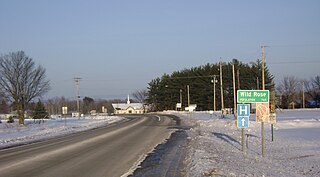
Wild Rose is a village in Waushara County, Wisconsin, United States. The population was 725 at the 2010 census.
Viola is a village in Richland (mostly) and Vernon Counties in the U.S. state of Wisconsin, United States. The population was 699 at the 2010 census. Of this, 477 were in Richland County, and 222 were in Vernon County.
Camillus is a village in Onondaga County, New York, United States. As of the 2020 census, the population was 1,222. The village takes its name from the town in which it is located. It is part of the Syracuse Metropolitan Statistical Area.
Nelson is a village in Buffalo County in the U.S. state of Wisconsin. The population was 374 at the 2010 census. The village is surrounded by the Town of Nelson.
Randolph is a village in Columbia and Dodge Counties in the U.S. state of Wisconsin. The population was 1,811 at the 2010 census. Of this, 1,339 were in Dodge County, and 472 were in Columbia County. The village is located at the southeast corner of the Town of Randolph in Columbia County, although only a tiny portion of the village lies within the town. Most of the village lies within the Town of Westford in Dodge County. Small portions also lie within the Town of Fox Lake to the north and the Town of Courtland in Columbia County.
Colfax is a village in Dunn County, Wisconsin, United States. The population was 1,158 at the 2010 census. The village is surrounded by the Town of Colfax.
Milltown is a village in Polk County, Wisconsin, United States. The population was 917 at the 2010 census. The village is located within the Town of Milltown.
Lohrville is a village in Waushara County, Wisconsin, United States. The population was 402 at the 2010 census.