Auburn, Chippewa County, Wisconsin

Last updated

Auburn, Wisconsin
WIMap-doton-Auburn.png
Location of Auburn, Wisconsin
Coordinates: 45°9′54″N91°37′8″W / 45.16500°N 91.61889°W / 45.16500; -91.61889
Country Flag of the United States.svg  United States
State Flag of Wisconsin.svg  Wisconsin
County Chippewa
Area
  Total35.7 sq mi (92.4 km2)
  Land35.7 sq mi (92.4 km2)
  Water0.0 sq mi (0.0 km2)
Elevation
[1]
1,152 ft (351 m)
Population
 (2010)
  Total697
  Density19/sq mi (7.5/km2)
Time zone UTC-6 (Central (CST))
  Summer (DST) UTC-5 (CDT)
Area codes 715 & 534
FIPS code 55-03725 [2]
GNIS feature ID1582729 [1]
Website townofauburn.net

Auburn is a town in Chippewa County in the U.S. state of Wisconsin. The population was 697 at the 2010 census, [3] up from 580 at the 2000 census.

Contents

History

The town was named from a place called Auburn, mentioned in the poem "The Deserted Village" by Oliver Goldsmith. [4]

Geography

The Town of Auburn is in northwestern Chippewa County and is bordered by Barron County to the north and Dunn County to the west. The village of New Auburn borders the northeast corner of the town. According to the United States Census Bureau, the town has a total area of 35.7 square miles (92.4 km2), all land. [3]

Demographics

Historical population
CensusPop.Note
1990 474
2000 58022.4%
2010 69720.2%
2020 (est.)7345.3%

As of the census [2] of 2000, there were 580 people, 202 households, and 163 families residing in the town. The population density was 16.2 people per square mile (6.3/km2). There were 210 housing units at an average density of 5.9 per square mile (2.3/km2). The racial makeup of the town was 98.45% White, 0.17% Native American, 0.17% from other races, and 1.21% from two or more races. Hispanic or Latino of any race were 0.17% of the population.

There were 202 households, out of which 33.7% had children under the age of 18 living with them, 73.8% were married couples living together, 3.5% had a female householder with no husband present, and 19.3% were non-families. 13.9% of all households were made up of individuals, and 5.0% had someone living alone who was 65 years of age or older. The average household size was 2.87 and the average family size was 3.19.

In the town, the population was spread out, with 27.2% under the age of 18, 8.4% from 18 to 24, 31.9% from 25 to 44, 22.6% from 45 to 64, and 9.8% who were 65 years of age or older. The median age was 34 years. For every 100 females, there were 112.5 males. For every 100 females age 18 and over, there were 112.1 males.

The median income for a household in the town was $36,000, and the median income for a family was $39,444. Males had a median income of $24,167 versus $19,063 for females. The per capita income for the town was $17,164. About 3.7% of families and 8.2% of the population were below the poverty line, including 11.9% of those under age 18 and 11.0% of those age 65 or over.

Notable people

Related Research Articles

<span class="mw-page-title-main">Agenda, Wisconsin</span> Town in Wisconsin, United States

Agenda is a town in Ashland County in the U.S. state of Wisconsin. The population was 422 at the 2010 census. The unincorporated communities of Holts Landing and Petes Landing are located in the town.

<span class="mw-page-title-main">Chippewa, Wisconsin</span> Town in Wisconsin, United States

Chippewa is a town in Ashland County in the U.S. state of Wisconsin. The population was 374 at the 2010 census.

<span class="mw-page-title-main">Dovre, Wisconsin</span> Town in Wisconsin, United States

Dovre is a town in Barron County in the U.S. state of Wisconsin. The population was 849 at the 2010 census.

<span class="mw-page-title-main">Russell, Bayfield County, Wisconsin</span> Town in Wisconsin, United States

Russell is a town in Bayfield County, Wisconsin, United States. The population was 1,279 at the 2010 census. The unincorporated communities of Red Cliff and Sand Bay are located in Russell. Red Cliff is the administrative center of the Red Cliff Band of Lake Superior Chippewa. York Island and Raspberry Island are part of the town.

<span class="mw-page-title-main">Maxville, Wisconsin</span> Town in Wisconsin, United States

Maxville is a town in Buffalo County in the U.S. state of Wisconsin. The population was 309 at the 2010 census. The ghost town of Savoy was located in the town.

<span class="mw-page-title-main">Birch Creek, Wisconsin</span> Town in Wisconsin, United States

Birch Creek is a town in Chippewa County in the U.S. state of Wisconsin. The population was 495 at the 2020 census.

<span class="mw-page-title-main">Cooks Valley, Wisconsin</span> Town in Wisconsin, United States

Cooks Valley is a town in Chippewa County in the U.S. state of Wisconsin. The population was 805 at the 2010 census, up from 632 at the 2000 census. The town was named after Jacob Cook, who purchased property in the valley in the summer of 1858. A post office was established in 1870 with William Miller as the first postmaster.

<span class="mw-page-title-main">Cornell, Wisconsin</span> City in Wisconsin, United States

Cornell is a city in Chippewa County, Wisconsin, United States. The population was 1,467 at the 2010 census. It is located on the Chippewa River, upstream from Lake Wissota and Chippewa Falls, where Highway 64 crosses the river and Highway 27.

<span class="mw-page-title-main">Edson, Wisconsin</span> Town in Wisconsin, United States

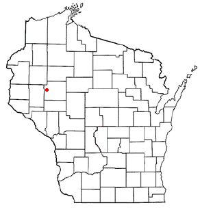
The Town of Edson is located in Chippewa County in the U.S. state of Wisconsin. The population was 1,089 at the 2010 census, up from 966 at the 2000 census.
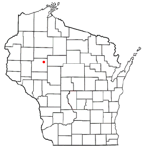
<span class="mw-page-title-main">Howard, Chippewa County, Wisconsin</span> Town in Wisconsin, United States

The Town of Howard is located in southwestern Chippewa County in the U.S. state of Wisconsin. The population was 798 at the 2010 census, up from 648 at the 2000 census. The unincorporated communities of Albertville and Howard are located in the town.

<span class="mw-page-title-main">Lafayette, Chippewa County, Wisconsin</span> Town in Wisconsin, United States

Lafayette is a town in Chippewa County in the U.S. state of Wisconsin. The population was 5,765 at the 2010 census. The census-designated place of Lake Wissota is located within the town. The unincorporated community of Bateman is also located in the town.

<span class="mw-page-title-main">Tilden, Wisconsin</span> Town in Wisconsin, United States

The Town of Tilden is located in Chippewa County in the U.S. state of Wisconsin. The population was 1,485 at the 2010 census, up from 1,185 at the 2000 census.

<span class="mw-page-title-main">Wheaton, Wisconsin</span> Town in Wisconsin, United States

The Town of Wheaton is located in Chippewa County in the U.S. state of Wisconsin. The population was 2,701 at the 2010 census, up from 2,366 at the 2000 census. The unincorporated communities of Old Albertville and Pine Grove are located in the town.

<span class="mw-page-title-main">Auburn, Fond du Lac County, Wisconsin</span> Town in Wisconsin, United States

Auburn is a town in Fond du Lac County, Wisconsin, United States. The population was 2,075 at the 2000 census. The unincorporated communities of New Fane and New Prospect are located within Auburn. The ghost town of New Cassel was also located in Auburn.

<span class="mw-page-title-main">Sherman, Iron County, Wisconsin</span> Town in Wisconsin, United States

Sherman is a town in Iron County, Wisconsin, United States. The population was 336 at the 2000 census. The unincorporated communities of Powell and Springstead are located in the town. The Lac du Flambeau Band of Lake Superior Chippewa is located partially in the town.

<span class="mw-page-title-main">Wild Rose, Wisconsin</span> Village in Wisconsin, United States

Wild Rose is a village in Waushara County, Wisconsin, United States. The population was 725 at the 2010 census.

<span class="mw-page-title-main">New Auburn, Wisconsin</span> Village in Wisconsin, United States

New Auburn is a village in Barron and Chippewa counties in the U.S. state of Wisconsin. The population was 548 at the 2010 census. Of this, 528 were in Chippewa County, and 20 were in Barron County. The village is located mostly within the Town of Auburn in Chippewa County. Small portions extend east into the adjacent Town of Bloomer, Chippewa County and north into the Town of Dovre in Barron County.

Nelson is a town in Buffalo County in the U.S. state of Wisconsin. The population was 571 at the 2010 census. The village of Nelson is located within the town. The unincorporated community of Misha Mokwa and railroad junction Trevino are located in the town. The unincorporated community of Urne is located partially in the town.

Bloomer is a town in Chippewa County in the U.S. state of Wisconsin. The population was 1,050 at the 2010 census, up from 926 at the 2000 census. The city of Bloomer is also located in Chippewa County, but to the south of the town within the adjacent town of Woodmohr.

<span class="mw-page-title-main">Aniwa, Wisconsin</span> Village in Wisconsin, United States

Aniwa is a village in Shawano County, Wisconsin, United States. The population was 260 at the 2010 census. The village is located within the Town of Aniwa. U.S. Route 45 runs north–south through the village.

References

  1. 1 2 "US Board on Geographic Names". United States Geological Survey. October 25, 2007. Retrieved January 31, 2008.
  2. 1 2 "U.S. Census website". United States Census Bureau . Retrieved January 31, 2008.
  3. 1 2 "Geographic Identifiers: 2010 Demographic Profile Data (G001): Auburn town, Chippewa County, Wisconsin". U.S. Census Bureau, American Factfinder. Retrieved September 11, 2015.[ dead link ]
  4. Chicago and North Western Railway Company (1908). A History of the Origin of the Place Names Connected with the Chicago & North Western and Chicago, St. Paul, Minneapolis & Omaha Railways. p. 185.
  5. 'Wisconsin Blue Book 1933,' Biographical Sketch of John E. Prince, pg. 230