This is a list of the National Register of Historic Places listings in Rock County, Wisconsin. It is intended to provide a comprehensive listing of entries in the National Register of Historic Places that are located in Rock County, Wisconsin. The locations of National Register properties for which the latitude and longitude coordinates are included below may be seen in a map.

This is a list of the National Register of Historic Places listings in Waukesha County, Wisconsin. It is intended to provide a comprehensive listing of entries in the National Register of Historic Places that are located in Waukesha County, Wisconsin. The locations of National Register properties for which the latitude and longitude coordinates are included below may be seen in a map.
This is a list of the National Register of Historic Places listings in Winnebago County, Wisconsin.

This is a list of the National Register of Historic Places listings in Brown County, Wisconsin. It is intended to provide a comprehensive listing of entries in the National Register of Historic Places that are located in Brown County, Wisconsin. The locations of National Register properties for which the latitude and longitude coordinates are included below may be seen in a map.

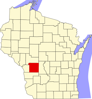
This is a list of the National Register of Historic Places listings in Grant County, Wisconsin. It is intended to provide a comprehensive listing of entries in the National Register of Historic Places that are located in Grant County, Wisconsin. The locations of National Register properties for which the latitude and longitude coordinates are included below may be seen in a map.

This is a list of the National Register of Historic Places listings in Iowa County, Wisconsin. It is intended to provide a comprehensive listing of entries in the National Register of Historic Places that are located in Iowa County, Wisconsin. The locations of National Register properties for which the latitude and longitude coordinates are included below may be seen in a map.

This is a list of the National Register of Historic Places listings in La Crosse County, Wisconsin. It is intended to provide a comprehensive listing of entries in the National Register of Historic Places that are located in La Crosse County, Wisconsin. The locations of National Register properties for which the latitude and longitude coordinates are included below may be seen in a map.

This is a list of the National Register of Historic Places listings in Ozaukee County, Wisconsin. It is intended to provide a comprehensive listing of entries in the National Register of Historic Places that are located in Ozaukee County, Wisconsin. The locations of National Register properties for which the latitude and longitude coordinates are included below may be seen in a map.

This is a list of the National Register of Historic Places listings in Sheboygan County, Wisconsin. It is intended to provide a comprehensive listing of entries in the National Register of Historic Places that are located in Sheboygan County, Wisconsin. The locations of National Register properties for which the latitude and longitude coordinates are included below may be seen in a map.

This is a list of the National Register of Historic Places listings in Walworth County, Wisconsin. It is intended to provide a comprehensive listing of entries in the National Register of Historic Places that are located in Walworth County, Wisconsin. The locations of National Register properties for which the latitude and longitude coordinates are included below may be seen in a map.
This is a list of the National Register of Historic Places listings in Washington County, Wisconsin. It is intended to provide a comprehensive listing of entries in the National Register of Historic Places that are located in Washington County, Wisconsin. The locations of National Register properties for which the latitude and longitude coordinates are included below may be seen in a map.
This is a list of the National Register of Historic Places listings in Portage County, Wisconsin. It is intended to provide a comprehensive listing of entries in the National Register of Historic Places that are located in Portage County, Wisconsin. The locations of National Register properties for which the latitude and longitude coordinates are included below may be seen in a map.
This is a list of the National Register of Historic Places listings in Monroe County, Wisconsin. It is intended to provide a comprehensive listing of entries in the National Register of Historic Places that are located in Monroe County, Wisconsin. The locations of National Register properties for which the latitude and longitude coordinates are included below may be seen in a map.
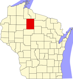
This is a list of the National Register of Historic Places listings in Price County, Wisconsin. It is intended to provide a comprehensive listing of entries in the National Register of Historic Places that are located in Price County, Wisconsin. The locations of National Register properties for which the latitude and longitude coordinates are included below may be seen in a map.

This is a list of the National Register of Historic Places listings in Vilas County, Wisconsin. It is intended to provide a comprehensive listing of entries in the National Register of Historic Places that are located in Vilas County, Wisconsin. The locations of National Register properties for which the latitude and longitude coordinates are included below may be seen in a map.

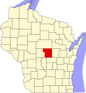
This is a list of the National Register of Historic Places listings in Wood County, Wisconsin. It is intended to provide a comprehensive listing of entries in the National Register of Historic Places that are located in Wood County, Wisconsin. The locations of National Register properties for which the latitude and longitude coordinates are included below may be seen in a map.

This is a list of the National Register of Historic Places listings in Dunn County, Wisconsin. It is intended to provide a comprehensive listing of entries in the National Register of Historic Places that are located in Dunn County, Wisconsin. The locations of National Register properties for which the latitude and longitude coordinates are included below may be seen in a map.

This is a list of the National Register of Historic Places listings in Sawyer County, Wisconsin. It is intended to provide a comprehensive listing of entries in the National Register of Historic Places that are located in Sawyer County, Wisconsin. The locations of National Register properties for which the latitude and longitude coordinates are included below may be seen in a map.

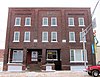
The Bridge Street Commercial Historic District is located in Chippewa Falls, Wisconsin.