National Register of Historic Places listings in Ashland County, Wisconsin
Last updated
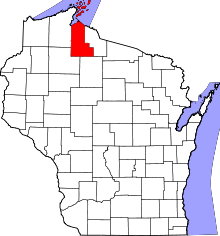
Location of Ashland County in Wisconsin
This is a list of the National Register of Historic Places listings in Ashland County, Wisconsin. It is intended to provide a comprehensive listing of entries in the National Register of Historic Places that are located in Ashland County, Wisconsin. The locations of National Register properties for which the latitude and longitude coordinates are included below may be seen in a map.
187-foot wood-hulled steamship built in 1861 that initially hauled passengers. Later converted to a schooner. Sank in 1897 carrying 1,000 tons of coal while being towed from the Ashlandore docks toward Duluth.[5]
58 foot concrete tower at the end of the 1.5 mile artificial breakwater which the Army Corps of Engineers finished in 1915. Built primarily to protect ships in the harbor loading iron ore from the Gogebic Range.[8]
Five Queen Anne-style homes on a block, designed by William H. Webster and built in 1887 for newspaperman and former Lieutenant GovernorSam Fifield to meet Ashland's need for housing due to the influx of people when the area's iron ore industry was established. Also Fifield's own 1883 home, designed by Antoine Perinier.[25]
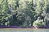
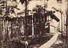
Norwegian immigrant Christian Hadland started this camp in 1938, and fished each year from late spring until fall. Site includes cabins, a shed for storing nets, an ice house, gill net winders, and drying frames.[27]
195 foot three-masted schooner built in 1873. On her last voyage in November 1886, dropped coal in Washburn, loaded 1256 tons of Gogebiciron ore at Ashland, and left for Cleveland. She sank in a snowstorm, with all crew lost.[31]
235 foot wooden bulk freighter built in 1881 in Cleveland. On Oct 15, 1903, heading east with iron ore in fair weather, she sprang a leak and sank. The crew escaped.[36]
The Queen Anne-style city hall designed by Henry Wildhagen and built in 1895 has housed police and fire department, an opera house on the second floor, a library, and now a museum.[37]
Graceful sailing schooner built in 1874 by Wolf & Davidson in Milwaukee. Her topmasts were removed in 1889 when she was converted to a barge. Sank in a storm in September 1903 while being towed with a load of iron ore out of Ashland.[39]
Prehistoric site on Stockton Island - probably a moose-hunting camp. Pottery fragments indicate one occupation around 900 CE and another around 1685.[40]
205-foot schooner-barge built in 1872 in Trenton, Michigan. On October 6, 1905, it was loaded with 600,000 board feet of hemlock lumber and being towed toward Bay City, Michigan when she caught fire and eventually sank.[41]
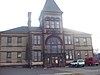
Monumental public building designed by Willoughby J. Edbrooke and built with locally quarried brownstone in 1892-93 as a post office. Has also housed a vocational school and now the city hall. It is considered by some the best example of Richardsonian Romanesque architecture in northern Wisconsin.[42]
338-foot schooner-barge built in 1900 in West Bay City, Michigan. On Sept. 1, 1905 she left Superior with a load of iron ore, towed by a steamer heading for Chicago. They were caught by the same storm that sank the Sevona, and the Pretoria sank with five crew lost.[44]
100 foot wooden passenger steamer built in 1878 in Buffalo.[45] On June 4, 1899 she ran off course in a fog and ran aground on Michigan Island, then caught fire. One crewman died.[46]
Cluster of fish camps on the east end of Rocky Island, small-scale enterprises operated from 1938 to 1958: Hadland, Benson, Edwards, Nelson & Erickson.[47]
Richardsonian Romanesque bank designed by local architects Conover and Porter and built in 1889 in brick and brownstone. Later occupied by the Ashland Light, Power and Street Railway Company. In 1935 the lower exterior was refinished with black granite.[48]
Steam-powered tugboat built in 1876. Served as a "purchase boat," collecting catch from remote fish camps as far away as Isle Royale or Canada. Sank in 1900.[51]
45 contributing commercial buildings built from 1884 to 1937[56] varying in style from the Blue Ribbon Bar[57] to the Northern National Bank[58] and the Royal Theatre
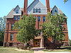
Georgian Revival mansion built in 1885 by Lewis Cass Wilmarth, Ashland's first banker. In 1918 a hospital wing was added, and the mansion end served as entry and offices for Ashland General Hospital until 1972. Now apartments.[60]
Site on a point of Madeline Island where Ojibwe, Odawa and Huron may have traded between 1600 and 1650. Later the site of Michel Cadotte's trading post, from roughly 1790 to 1833.[61]
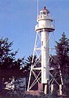
The La Pointe Light is a lighthouse located on Long Island, one of the Apostle Islands, in Lake Superior in Ashland County, Wisconsin, near the city of Bayfield.
There are several historic lighthouses on Lake Superior on or near the Apostle Islands in Wisconsin. Six of these lighthouses, all in the Apostle Islands National Lakeshore, were listed as a group on the National Register of Historic Places in 1977 under the name Apostle Islands Lighthouses.
This is a list of the National Register of Historic Places listings in Winnebago County, Wisconsin.
This is a list of the National Register of Historic Places listings in Sauk County, Wisconsin. It is intended to provide a comprehensive listing of entries in the National Register of Historic Places that are located in Sauk County, Wisconsin. The locations of National Register properties for which the latitude and longitude coordinates are included below may be seen in a map.
This is a list of the National Register of Historic Places listings in Brown County, Wisconsin. It is intended to provide a comprehensive listing of entries in the National Register of Historic Places that are located in Brown County, Wisconsin. The locations of National Register properties for which the latitude and longitude coordinates are included below may be seen in a map.
This is a list of the National Register of Historic Places listings in Columbia County, Wisconsin.
This is a list of the National Register of Historic Places listings in Door County, Wisconsin. It is intended to provide a comprehensive listing of entries in the National Register of Historic Places that are located in Door County, Wisconsin. The locations of National Register properties for which the latitude and longitude coordinates are included below may be seen in a map.
This is a list of the National Register of Historic Places listings in Eau Claire County, Wisconsin. It is intended to provide a comprehensive listing of entries in the National Register of Historic Places that are located in Eau Claire County, Wisconsin. The locations of National Register properties for which the latitude and longitude coordinates are included below may be seen in a map.
This is a list of the National Register of Historic Places listings in La Crosse County, Wisconsin. It is intended to provide a comprehensive listing of entries in the National Register of Historic Places that are located in La Crosse County, Wisconsin. The locations of National Register properties for which the latitude and longitude coordinates are included below may be seen in a map.
This is a list of the National Register of Historic Places listings in Ozaukee County, Wisconsin. It is intended to provide a comprehensive listing of entries in the National Register of Historic Places that are located in Ozaukee County, Wisconsin. The locations of National Register properties for which the latitude and longitude coordinates are included below may be seen in a map.
This is a list of the National Register of Historic Places listings in Walworth County, Wisconsin. It is intended to provide a comprehensive listing of entries in the National Register of Historic Places that are located in Walworth County, Wisconsin. The locations of National Register properties for which the latitude and longitude coordinates are included below may be seen in a map.
This is a list of the National Register of Historic Places listings in Lake County, Minnesota. It is intended to be a complete list of the properties and districts on the National Register of Historic Places in Lake County, Minnesota, United States. The locations of National Register properties and districts for which the latitude and longitude coordinates are included below, may be seen in an online map.
This is a list of the National Register of Historic Places listings in Bayfield County, Wisconsin. It is intended to provide a comprehensive listing of entries in the National Register of Historic Places that are located in Bayfield County, Wisconsin. The locations of National Register properties for which the latitude and longitude coordinates are included below may be seen in a map.
This is a list of the National Register of Historic Places listings in Manitowoc County, Wisconsin. It is intended to provide a comprehensive listing of entries in the National Register of Historic Places that are located in Manitowoc County, Wisconsin. The locations of National Register properties for which the latitude and longitude coordinates are included below may be seen in a map.
This is a list of the National Register of Historic Places listings in Chippewa County, Wisconsin. It is intended to provide a comprehensive listing of entries in the National Register of Historic Places that are located in Chippewa County, Wisconsin. The locations of National Register properties for which the latitude and longitude coordinates are included below may be seen in a map.
This is a list of the National Register of Historic Places listings in Price County, Wisconsin. It is intended to provide a comprehensive listing of entries in the National Register of Historic Places that are located in Price County, Wisconsin. The locations of National Register properties for which the latitude and longitude coordinates are included below may be seen in a map.
This is a list of the National Register of Historic Places listings in Wood County, Wisconsin. It is intended to provide a comprehensive listing of entries in the National Register of Historic Places that are located in Wood County, Wisconsin. The locations of National Register properties for which the latitude and longitude coordinates are included below may be seen in a map.
This is a list of the National Register of Historic Places listings in Sawyer County, Wisconsin. It is intended to provide a comprehensive listing of entries in the National Register of Historic Places that are located in Sawyer County, Wisconsin. The locations of National Register properties for which the latitude and longitude coordinates are included below may be seen in a map.
1 2 Numbers represent an alphabetical ordering by significant words. Various colorings, defined here, differentiate National Historic Landmarks and historic districts from other NRHP buildings, structures, sites or objects.
↑ The eight-digit number below each date is the number assigned to each location in the National Register Information System database, which can be viewed by clicking the number.
↑ "Lighthouses of the Apostles". Apostle Islands National Lakeshore - Wisconsin. National Park Service - U.S. Department of the Interior. Retrieved 10 December 2012.
↑ Parnes, Herschel L. D. "Bass Island Brownstone Quarry". National Register of Historic Places Inventory - Nomination Form. National Park Service. Retrieved 2013-10-13.
↑ "Glidden State Bank". Wisconsin Historical Society. January 2012. Retrieved 2013-02-08.
↑ Parnes, Herschel L. D. "Hadland Fishing Camp". National Register of Historic Places - Inventory/Nomination Form. National Park Service. Retrieved 2013-02-21.
↑ Weburg, Michael M. (1976-08-02). "LaPointe Indian Cemetery". NRHP Inventory-Nomination Form. US Dept. of the Interior. National Park Service. Retrieved 2015-09-21.
1 2 Location given in Kohl, Cris (2001). The Great Lakes Diving Guide. West Chicago, Ill.: Seawolf Communications, Inc. NRIS lists site as "address restricted".
↑ Lidfors, Kathleen (May 1981). "Manitou Camp". National Register of Historic Places Inventory-Nomination Form. National Park Service. Retrieved 2013-03-07.
↑ "Mellen City Hall". Wisconsin Historical Society. January 2012. Retrieved 2013-02-08.
↑ "Memorial Hall". Historic Campus Architecture Project. Council of Independent Colleges. Archived from the original on 2015-12-10. Retrieved 2013-03-09.
↑ Birmingham, Robert A. (1992). "Historic Period Indian Archeology at La Pointe in Lake Superior: an Overview". The Wisconsin Archeologist. 73 (3–4): 180–181.
↑ "Noquebay". Wisconsin's Great Lakes Shipwrecks. Wisconsin Historical Society & UW Sea Grant Institute. Archived from the original on 2013-06-02. Retrieved 2013-03-22.
↑ "Old Ashland Post Office". Architecture and History Inventory. Wisconsin Historical Society. January 2012. Retrieved 2013-03-22.
↑ Birmingham, Robert A. (1992). "Historic Period Indian Archeology at La Pointe in Lake Superior: an Overview". The Wisconsin Archeologist. 73 (3–4): 189.
↑ "Pretoria". Great Lakes Shipwrecks. Wisconsin Historical Society and University of Wisconsin Sea Grant. Archived from the original on 2013-06-02. Retrieved 2013-03-28.
↑ "R.G. Stewart (1878)". Wisconsin Historical Society Shipwreck Database. Wisconsin Historical Society. Retrieved January 29, 2018.
This page is based on this Wikipedia article Text is available under the CC BY-SA 4.0 license; additional terms may apply. Images, videos and audio are available under their respective licenses.