Location | Ashland, Wisconsin |
---|---|
Coordinates | 46°37′42″N90°52′12″W / 46.62833°N 90.87000°W |
Tower | |
Constructed | 1915 [1] |
Foundation | Concrete pier |
Construction | Reinforced concrete / steel |
Height | 58 feet (18 m) [2] |
Shape | Cylindrical watch room on octagonal pyramid tower [3] |
Markings | white with red cap on lantern |
Heritage | National Register of Historic Places listed place |
Light | |
First lit | 1915 |
Focal height | 60 feet (18 m) [4] |
Lens | Fourth order Fresnel lens (original), 9.8-inch (250 mm) acrylic plastic lens solar powered [3] (current) |
Range | 9 nautical miles (17 km; 10 mi) [5] |
Characteristic | White, Flashing, 6 sec [5] |
Ashland Harbor Breakwater Light | |
Nearest city | Ashland, Wisconsin |
Area | less than one acre |
Architect | U.S. Bureau of Lighthouses; 11th District |
MPS | Light Stations of the United States MPS |
NRHP reference No. | 07000103 [6] |
Added to NRHP | March 1, 2007 |
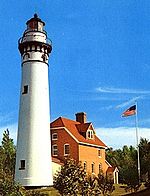
The Ashland Harbor Breakwater lighthouse, also known as Ashland Breakwater Lighthouse, is an operational lighthouse located near Ashland in Ashland County, Wisconsin, USA. [7] Located in Chequamegon Bay of Lake Superior, it is owned and managed by the National Park Service, and is a part of the Apostle Islands National Lakeshore. [8] It sits at the end of a long and detached breakwater, which creates an artificial harbor. [9]
A lighthouse keeper's quarters and a boathouse, constructed in 1916, are located about 2 miles (3.2 km) from the light. There are additional living quarters on the second and third stories of the lighthouse. [10]
The Holland Harbor Light, known as Big Red, is located in Park Township, Michigan at the entrance of a channel connecting Lake Michigan with Lake Macatawa, and which gives access to the city of Holland, Michigan.
The Charlevoix South Pier Light Station is located on Lake Michigan at the entrance to Lake Charlevoix in Charlevoix County in the U.S. state of Michigan at the end of the south pier/breakwater of the channel leading to Round Lake in the city of Charlevoix.
The La Pointe Light is a lighthouse located on Long Island, one of the Apostle Islands, in Lake Superior in Ashland County, Wisconsin, near the city of Bayfield.
The Chequamegon Point Lighthouse is a lighthouse located on Long Island, one of the Apostle Islands, in Lake Superior in Ashland County, Wisconsin, near the city of Bayfield.
The Devils Island Lighthouse is a lighthouse located on Devils Island, one of the Apostle Islands, in Lake Superior in Ashland County, Wisconsin, near the city of Bayfield. Among the Apostle Islands lighthouses—a testament to its remoteness—it was the last built, and the last automated and unmanned.
The Outer Island lighthouse is a lighthouse located on the northern tip of Outer Island, one of the Apostle Islands, in Lake Superior in Ashland County, Wisconsin, near the city of Bayfield.
There are several historic lighthouses on Lake Superior on or near the Apostle Islands in Wisconsin. Six of these lighthouses, all in the Apostle Islands National Lakeshore, were listed as a group on the National Register of Historic Places in 1977 under the name Apostle Islands Lighthouses.
The Raspberry Island Lighthouse is a lighthouse located on the southern part of Raspberry Island, marking the west channel of the Apostle Islands in Lake Superior in Bayfield County, Wisconsin, near the city of Bayfield. It was erected in 1862, marking the western channel.
The Wisconsin Point Light is a lighthouse located in Superior, on Wisconsin Point, in Douglas County, Wisconsin, United States.
Kenosha Light Station is a lighthouse and keeper's house on Simmons Island north of the channel into Kenosha's harbor in Kenosha County, Wisconsin.
The Kenosha North Pier Light, also known as the Kenosha North Pierhead Light, is a lighthouse located in Kenosha, Wisconsin. "A typical 'Lake Michigan red tower'", it is a sibling to the Milwaukee Pierhead Light. This light was built in 1906 as a replacement of the old Kenosha Light Station. It was listed on the National Register of Historic Places in 2008.
The Baileys Harbor Range Lights are a pair of lighthouses arranged in a range light configuration, located near Baileys Harbor in Door County, Wisconsin, United States.
Wind Point Lighthouse is a lighthouse located at the north end of Racine Harbor in the U.S. state of Wisconsin. It is in the village of Wind Point, Wisconsin, on Lighthouse Road, next to the Shoop Park golf course. The lighthouse stands 108 feet (33 m) tall. One of the oldest and tallest active lighthouses on the Great Lakes, it was listed on the National Register of Historic Places in 1984.
The Chicago Harbor Lighthouse is an automated active lighthouse, and stands at the south end of the northern breakwater protecting the Chicago Harbor, to the east of Navy Pier and the mouth of the Chicago River.
The Milwaukee Pierhead Light is an active lighthouse located in the Milwaukee harbor, just south of downtown. This aid to navigation is a 'sister' of the Kenosha North Pier Light.
The Milwaukee Breakwater lighthouse was built in 1926 in the harbor of Milwaukee in Milwaukee County, Wisconsin to mark the entrance to the harbor. One of the last fully enclosed breakwater lighthouses in the Great Lakes, the structure was placed on the National Register of Historic Places in 2011.
The Harbor Beach Lighthouse is a "sparkplug lighthouse" located at the end of the north breakwall entrance to the harbor of refuge on Lake Huron. The breakwall and light were created by the United States Army Corps of Engineers to protect the harbor of Harbor Beach, Michigan, which is the largest man-made freshwater harbor in the world. Harbor Beach is located on the eastern edge of the Thumb of Huron County, in the state of Michigan.
The Marquette Harbor Light is located on Lake Superior in Marquette, Michigan, a part of the Upper Peninsula. It is an active aid to navigation.
The Duluth Harbor North Pier Light is a lighthouse on the north breakwater of the Duluth Ship Canal in Duluth, Minnesota, United States.
The Racine Harbor Lighthouse and Life Saving Station is a complex of navigation aids begun by the U.S. government in the 1860s near the harbor of Racine, Wisconsin. It was added to the National Register of Historic Places in 1975.