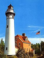
A lighthouse is a tower, building, or other type of physical structure designed to emit light from a system of lamps and lenses and to serve as a beacon for navigational aid, for maritime pilots at sea or on inland waterways.
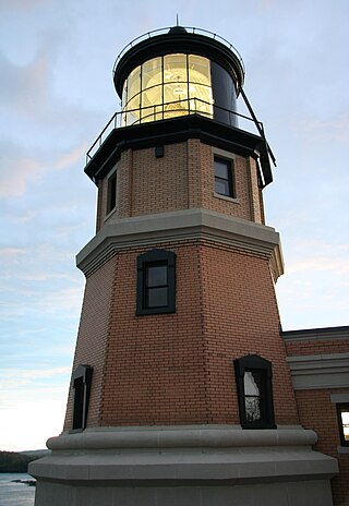
Split Rock Lighthouse is a lighthouse located southwest of Silver Bay, Minnesota, USA on the North Shore of Lake Superior. The structure was designed by lighthouse engineer Ralph Russell Tinkham and was completed in 1910 by the United States Lighthouse Service at a cost of $75,000, including the buildings and the land. It is considered one of the most picturesque lighthouses in the United States.

Pottawatomie Lighthouse, also known as the Rock Island Light, is a lighthouse in Rock Island State Park, on Rock Island in Door County, Wisconsin. Lit in 1836, it is the oldest light station in Wisconsin and on Lake Michigan. It was served by civilian light keepers from 1836 to the 1940s, at which point it was taken over by the US Coast Guard.
The history of lighthouses refers to the development of the use of towers, buildings, or other types of structure, as an aid to navigation for maritime pilots at sea or on inland waterways.
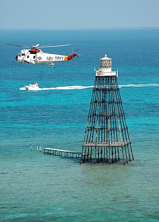
Sand Key Light is a lighthouse 6 nautical miles southwest of Key West, Florida, between Sand Key Channel and Rock Key Channel, two of the channels into Key West, on a reef intermittently covered by sand. At times the key has been substantial enough to have trees, and in 1900 nine to twelve thousand terns nested on the island. At other times the island has been washed away completely.
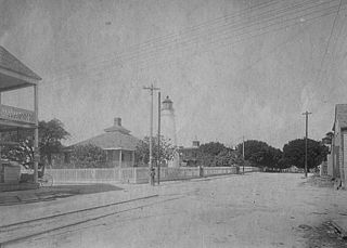
The Key West Lighthouse is located in Key West, Florida. The first Key West lighthouse was a 65-foot (20 m) tower completed in 1825. It had 15 lamps in 15-inch (380 mm) reflectors.

The Lynde Point Light or Lynde Point Lighthouse, also known as Saybrook Inner Lighthouse, is a lighthouse in Connecticut, United States, on the west side of the mouth of the Connecticut River on the Long Island Sound, Old Saybrook, Connecticut. The first light was a 35 feet (11 m) wooden tower constructed by Abisha Woodward for $2,200 and it was completed in 1803. A new lighthouse was eventually needed and a total of $7,500 was appropriated on July 7, 1838. Jonathan Scranton, Volney Pierce, and John Wilcox were contracted to build the new 65-foot (20 m) octagonal brownstone tower. It was constructed in 1838 and lit in 1839. The lighthouse was renovated in 1867 and had its keeper's house from 1833 replaced in 1858 with a Gothic Revival gambrel-roofed wood-frame house. In 1966, the house was torn down and replaced by a duplex house. The original ten lamps were replaced in 1852 with a fourth-order Fresnel lens, and with a fifth-order Fresnel lens in 1890. Lynde Point Lighthouse used whale oil until 1879 when it switched to kerosene. It was electrified in 1955 and fully automated by the United States Coast Guard in 1978. In 1990, it was added to the National Register of Historic Places and is significant for its "superior stone work in the tapering brownstone walls".

The Mobile Point Range Lights were a series of lighthouses at the entrance to Mobile Bay, at Mobile Point on the tip of the Fort Morgan peninsula, near Mobile, Alabama, United States. The first lighthouse was built as a landfall light by June 1822 at a cost of $9,995. The lighthouse was a conical brick masonry tower, 40 feet (12 m) tall. It was first lit on 29 September 1822. Fort Morgan was built adjacent to the lighthouse in 1833. The lighthouse was joined by the 200-foot (61 m) Sand Island Light across the mouth of the bay, about 3 miles (4.8 km) away in 1858. This resulted in the Mobile Point Lighthouse being downgraded to a harbor light, at the same time a fourth order Fresnel lens was installed. A period photograph, taken prior to the American Civil War, shows two shorter masonry towers standing on the beach below the main tower, they served as range lights. The lighthouse was subsequently destroyed by cannonball fire in the Battle of Mobile Bay during the Civil War.

Concord Point Light is a 36-foot (11 m) lighthouse in Havre de Grace, Maryland. It overlooks the point where Susquehanna River flows into the Chesapeake Bay, an area of increasing navigational traffic when it was constructed in 1827. It is the northernmost lighthouse and the second-oldest tower lighthouse still standing on the bay.
The Grassy Island Range Lights were a pair of lighthouses which were originally established to guide traffic through the channel into Green Bay harbor. They were deactivated and moved to shore as part of a channel-widening project.

Plum Island Light is located on the western end of Plum Island, which lies in the Long Island Sound, east of Orient Point at the end of the North Fork of Long Island, New York. An historic granite lighthouse originally built in 1869 sits at the site, but no longer serves as an active aid to navigation. It was listed on the National Register of Historic Places in 2011.

The Sand Point Lighthouse is located in Escanaba, Michigan, United States, on Lake Michigan's northern shore. Since 1989, it has been an unofficial aid to navigation. Though it is an operational aid to navigation. The restored lighthouse is now open to the public during the summer months. It is also known as the Escanaba/Sand Point Light or the Escanaba Light.

Ship Island Light was a lighthouse in Mississippi near Gulfport.

The Green Island Light is a lighthouse located on Green Island in Green Bay. Abandoned since its deactivation in 1956, it survives as a hollow shell near the existing skeleton tower.
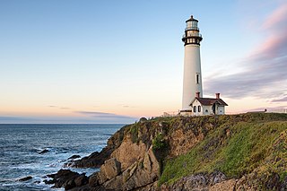
Pigeon Point Light Station or Pigeon Point Lighthouse is a lighthouse built in 1871 to guide ships on the Pacific coast of California. It is the tallest lighthouse on the West Coast of the United States. It is still an active Coast Guard aid to navigation. Pigeon Point Light Station is located on the coastal highway, 5 miles (8 km) south of Pescadero, California, between Santa Cruz and San Francisco. The 115-foot (35 m), white masonry tower, resembles the typical New England structure.

The Ontonagon Light is a lighthouse located off M-64 near Ontonagon, Michigan. It was listed on the National Register of Historic Places in 1975 and designated a Michigan State Historic Site in 1973.
The Green Bay Harbor Entrance Light is an offshore lighthouse near Green Bay, Wisconsin. Located 10 miles (16 km) from the mouth of the Fox River, it was erected to signal the entrance to Green Bay.
The Sheboygan Lighthouse stood on North Point in Sheboygan, Wisconsin. Improvements to the harbor rendered it obsolete, and it was deactivated in the early 20th century. The much altered second light survives as a private residence.
The Minnesota Point Light was a historic lighthouse on Minnesota Point in Duluth, Minnesota, United States, on the shores of Lake Superior. Built in 1858, it was the first lighthouse in the state, but is now a truncated ruined tower. The ruin was listed on the National Register of Historic Places in 1974 for its state-level significance in the theme of transportation. It was nominated for being the first high-powered lighthouse on Lake Superior, and the zero-point for all original surveys of the lake.

The Racine Reef Light was a lighthouse located in Lake Michigan some two miles east of Racine, Wisconsin, marking the edge of its eponymous shallows. It was torn down in 1961 and replaced with a skeleton tower on the same foundation.