Bailey's Harbor Lower Range Light plaque.
 Lower Range Light with skeleton tower removed.
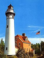
 Plaque at the base of the lower range light for The Ridges Sanctuary.
 | |
 | |
| Location | Baileys Harbor, Wisconsin |
|---|---|
| Coordinates | 45°04′13″N87°07′11″W / 45.07028°N 87.11972°W [ citation needed ] |
| Tower | |
| Constructed | 1869 |
| Foundation | Field stone |
| Construction | Wood |
| Automated | 1930 |
| Height | 21 feet (6.4 m) |
| Shape | Square base, upper is octagonal |
| Markings | KRW |
| Heritage | National Register of Historic Places contributing property |
| Light | |
| First lit | 1869 |
| Deactivated | 1969-2015 |
| Focal height | 7 m (23 ft) |
| Lens | Fifth order Fresnel (1897) [1] (original), LED (current) |
| Characteristic | F R |
| Baileys Harbor Range Rear Light | |
 Rear range light | |
| Coordinates | 45°04′22″N87°07′16″W / 45.07278°N 87.12111°W [ citation needed ] |
| Constructed | 1870 |
| Foundation | Field stone |
| Construction | Wood |
| Automated | 1930 |
| Height | 30 feet (9.1 m) [2] |
| Shape | Square, atop a house |
| Markings | White w/black and red markings |
| Heritage | National Register of Historic Places contributing property |
| First lit | 1870 |
| Deactivated | 1969-2015 |
| Focal height | 36 feet (11 m) [3] |
| Lens | Fifth order Fresnel (original), LED (current) |
| Characteristic | directional mark |
| Baileys Harbor Directional Light | |
| Foundation | Concrete |
| Construction | Metal skeleton tower with red/white/red dayboard [4] |
| Height | 21 m (69 ft) |
| First lit | 1969 |
| Deactivated | 2015 |
| Focal height | 21 m (69 ft) |
| Characteristic | White light Flashing every 2.5 seconds,with a higher intensity beam on a bearing of 340° [5] [6] |
Baileys Harbor Range Light | |
  | |
| Location | Roughly Co. Rd. Q, Ridges Rd., and WI 57, Baileys Harbor, Wisconsin |
| Coordinates | 45°4′19″N87°7′13″W / 45.07194°N 87.12028°W |
| Area | 5.4 acres (2.2 ha) |
| Built | 1869 |
| Architect | Breitbach, Andrew |
| NRHP reference No. | 89001466 [7] |
| Added to NRHP | September 21, 1989 |
The Baileys Harbor Range Lights are a pair of lighthouses arranged in a range light configuration, located near Baileys Harbor in Door County, Wisconsin, United States.