Plum Island Range Lights

Last updated
Plum Island PlumsIslandWisconsinLakeMichigan.jpg
Plum Island

Upon taking control of the island, the United States Fish and Wildlife Service initially closed Plum Island to public access to "ensure necessary protection of ground nesting migratory birds." [15] The island was opened to the public for seasonal day-time use in 2017. The island can be visited by private boat, kayak, or limited ferry from Gills Rock. Multiple hiking trails are available, however, buildings on the island are not generally accessible. [16]

Related Research Articles

<span class="mw-page-title-main">Pottawatomie Light</span> Lighthouse in Wisconsin, United States

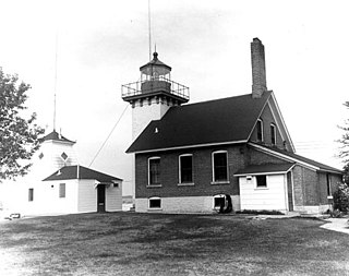
Pottawatomie Lighthouse, also known as the Rock Island Light, is a lighthouse in Rock Island State Park, on Rock Island in Door County, Wisconsin. Lit in 1836, it is the oldest light station in Wisconsin and on Lake Michigan. It was served by civilian light keepers from 1836 to 1946, at which point it was automated.

<span class="mw-page-title-main">Kenosha Light</span> Lighthouse

Kenosha Light is a lighthouse and keeper's house on Simmons Island north of the channel into Kenosha's harbor in Kenosha County, Wisconsin, USA.

<span class="mw-page-title-main">Kenosha North Pier Light</span> Lighthouse in Wisconsin, United States

The Kenosha North Pier lighthouse or Kenosha Light is a lighthouse located in Kenosha, Wisconsin. "A typical 'Lake Michigan red tower'", it is a sibling to the Milwaukee Pierhead Light. This light was built in 1906 as a replacement for the old Kenosha Light. It was listed on the National Register of Historic Places in 2008.

<span class="mw-page-title-main">Baileys Harbor Range Lights</span>

The Baileys Harbor Range Lights are a pair of lighthouses arranged in a range light configuration, located near Baileys Harbor in Door County, Wisconsin, United States.

<span class="mw-page-title-main">Cana Island Light</span> Lighthouse

The Cana Island lighthouse is a lighthouse located just north of Baileys Harbor in Door County, Wisconsin, United States.

<span class="mw-page-title-main">Baileys Harbor Light</span> Lighthouse in Wisconsin, United States

The Baileys Harbor lighthouse is a lighthouse located near Baileys Harbor in Door County, Wisconsin.

<span class="mw-page-title-main">Chambers Island Light</span> Lighthouse

The Chambers Island lighthouse is a lighthouse located on Chambers Island in Door County, Wisconsin. It was replaced in 1961 by a skeletal tower, visible for 12 nautical miles. The new light is identified by the USCG as 7-21895.

<span class="mw-page-title-main">Eagle Bluff Light</span> Lighthouse

The Eagle Bluff Light, also known as Eagle Bluff lighthouse, or simply Eagle Bluff, is a lighthouse located near Ephraim in Peninsula State Park in Door County, Wisconsin. Construction was authorized in 1866, but the lighthouse was not actually built until 1868 at a cost of $12,000. It was automated in 1926. Restoration work began on the Eagle Bluff Light in 1960 and was completed in 1963, upon completion the Lighthouse was opened for tours. The lighthouse was added to the National Register of Historic Places in 1970.

<span class="mw-page-title-main">Pilot Island Light</span> Lighthouse in Wisconsin, United States

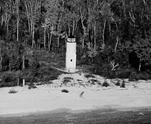
The Pilot Island Light is a lighthouse located near Gills Rock, on Pilot Island at the east end of Death's Door passage, in Door County, Wisconsin.

<span class="mw-page-title-main">Sherwood Point Light</span> Lighthouse

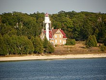
The Sherwood Point lighthouse is a lighthouse located near Idlewild in Door County, Wisconsin, United States.

<span class="mw-page-title-main">Sturgeon Bay Canal Light</span> Lighthouse at the south entrance to the Sturgeon Bay Ship Canal, Wisconsin

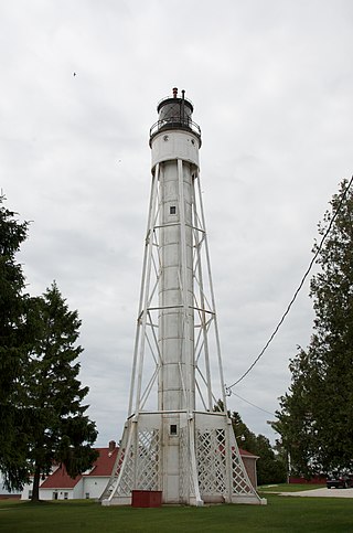
The Sturgeon Bay Canal lighthouse is a lighthouse located at the Coast Guard station near Sturgeon Bay in Door County, Wisconsin.

<span class="mw-page-title-main">Sturgeon Bay Canal North Pierhead Light</span> Lighthouse in Wisconsin, United States

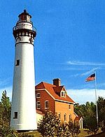
The Sturgeon Bay Canal North Pierhead Light is a lighthouse located on Sturgeon Bay in Door County, Wisconsin.

<span class="mw-page-title-main">Algoma Light</span> Lighthouse

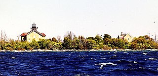
The Algoma Light or Algoma Pierhead Light is a lighthouse located near Algoma in Kewaunee County, Wisconsin.

<span class="mw-page-title-main">Whitefish Point Light</span> Lighthouse on the Upper Peninsula of Michigan, United States

The Whitefish Point Light is a lighthouse located in Chippewa County in the U.S. state of Michigan. Located on the southeastern shores of Lake Superior, it sits at the edge of Whitefish Point leading to Whitefish Bay. Constructed in 1849, it is the oldest operating lighthouse in the Upper Peninsula. All vessels entering or exiting Lake Superior pass near Whitefish Point. The area is infamously known as the "Graveyard of the Great Lakes" due to the high number of shipwrecks in the area, most famously the SS Edmund Fitzgerald.

<span class="mw-page-title-main">Plum Island (Wisconsin)</span>

Plum Island is an island in Lake Michigan in the southern part of the town of Washington in Door County, off the tip of the Door Peninsula in the U.S. state of Wisconsin. The uninhabited island has a land area of 1.179 square kilometres (0.455 sq mi) or 117.87 hectares. Carp Lake is located on the northwestern side. During years when Lake Michigan's water levels are high, it is a lagoon of Lake Michigan, but it gets cut off as a separate lake during low water years.

<span class="mw-page-title-main">Wind Point Light</span> Lighthouse

Wind Point Lighthouse is a lighthouse located at the north end of Racine Harbor in the U.S. state of Wisconsin. It is in the village of Wind Point, Wisconsin, on Lighthouse Road, next to the Shoop Park golf course. The lighthouse stands 108 feet (33 m) tall. One of the oldest and tallest active lighthouses on the Great Lakes, it was listed on the National Register of Historic Places in 1984.

<span class="mw-page-title-main">Milwaukee Pierhead Light</span> Lighthouse

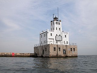
The Milwaukee Pierhead Light is an active lighthouse located in the Milwaukee harbor, just south of downtown. This aid to navigation is a 'sister' of the Kenosha North Pier Light.

<span class="mw-page-title-main">Milwaukee Breakwater Light</span> Lighthouse

The Milwaukee Breakwater lighthouse was built in 1926 in the harbor of Milwaukee in Milwaukee County, Wisconsin to mark the entrance to the harbor. One of the last fully enclosed breakwater lighthouses in the Great Lakes, the structure was placed on the National Register of Historic Places in 2011.

Green Bay National Wildlife Refuge is a National Wildlife Refuge of the United States located in the state of Wisconsin. It includes five all or part of six islands in Lake Michigan: Hog Island, Plum Island, Pilot Island, part of St. Martin Island and Rocky Island. Additionally it includes part of Detroit Island. The islands are near Washington Island off the tip of the Door Peninsula of Wisconsin and the Garden Peninsula of Michigan.

The Wisconsin Islands Wilderness is a 29-acre (12 ha) wilderness area located in Door County in northeastern Wisconsin. It is one of the smallest wilderness areas in the United States. Managed by the U.S. Fish & Wildlife Service, the wilderness area is composed of three islands in Lake Michigan.

References

  1. Plum Island Range Front Light and Plum Island Range Rear Light in Lighthouse Resources: Historic Lighthouses & Light Stations, United States Coast Guard, October 1, 2019
  2. Plum Island Range Lights by Terry Pepper, Seeing the Light June 21, 2004, (Archived January 20, 2022)
  3. "Amateur Radio Lighthouse Society, Plum Island Rear Range (Lake Michigan) Light ARLHS USA-608".
  4. Light List, Volume VII, Great Lakes (PDF). Light List. United States Coast Guard. 2014.
  5. "National Register Information System". National Register of Historic Places . National Park Service. March 13, 2009.
  6. University of Wisconsin Sea Grant. "Wisconsin's Great Lakes Shipwrecks: Death's Door". Wisconsin: University of Wisconsin Sea Grant Institute. Archived from the original on December 3, 2010. Retrieved March 23, 2011.
  7. 1 2 3 "History". Friends of Plum & Pilot Islands. Retrieved 2023-09-03.
  8. "Plum Island Fresnel Lens". Door County Maritime Museum. 10 May 2017. Retrieved 20 July 2021.
  9. 1 2 D'Entremont, Jeremy. "Islands at Death's Door" (October, 2003) Lighthouse Digest, Archived March 26, 2016
  10. 1 2 Foss, Matt (n.d.). "Saving the U.S. Life-Saving Station on Plum Island" (PDF). Friends of Plum and Pilot Islands, Inc. p. 30. Retrieved March 23, 2011.[ permanent dead link ]
  11. Lighting the Way for the Future of Plum and Pilot Islands, Fish and Wildlife Journal, Midwest Region, May 16, 2008, (Archived May 9, 2009)
  12. Rowlett, Russ. "Lighthouses of the United States: Eastern Wisconsin". The Lighthouse Directory. University of North Carolina at Chapel Hill.
  13. Wobser, David, Plum Island Range Lights Archived 2009-08-02 at the Wayback Machine at boatnerd.com.
  14. United States Fish and Wildlife Service (USFWS) (October 31, 2010). "Green Bay National Wildlife Refuge Historic Boathouse Receives a New Coat of Paint". USFWS. Retrieved March 23, 2011.[ permanent dead link ]
  15. United States Fish and Wildlife Service (USFWS). "Green Bay National Wildlife Refuge". USFWS. Archived from the original on December 2, 2013. Retrieved March 23, 2011.
  16. Jackson Parr (9 June 2017). "Discovering Plum Island: Historic Island Now Open to Public". Door County Pulse. Retrieved January 28, 2019.

Further reading

Plum Island Range Lights
Location Plum Island, Door County, US
Coordinates 45°18′29″N86°57′29″W / 45.308°N 86.958°W / 45.308; -86.958
Tower
Constructed1896  OOjs UI icon edit-ltr-progressive.svg
Plum Island Range rear light OOjs UI icon edit-ltr-progressive.svg
Plum Island.JPG
Rear range light with house
Constructed1896  OOjs UI icon edit-ltr-progressive.svg
Constructionconcrete (foundation), iron (tower)  OOjs UI icon edit-ltr-progressive.svg
Automated1960s  OOjs UI icon edit-ltr-progressive.svg
Height20 m (66 ft)  OOjs UI icon edit-ltr-progressive.svg
Shapeskeletal [1] [2] [3]
MarkingsKRW KRW.png [4]
HeritageNational Register of Historic Places listed place  OOjs UI icon edit-ltr-progressive.svg
First lit1897  OOjs UI icon edit-ltr-progressive.svg
Focal height24 m (79 ft)  OOjs UI icon edit-ltr-progressive.svg
Lensfourth order Fresnel lens  OOjs UI icon edit-ltr-progressive.svg
Range14 nmi (26 km; 16 mi)  OOjs UI icon edit-ltr-progressive.svg
Characteristic F R  OOjs UI icon edit-ltr-progressive.svg