The Two Harbors Light is the oldest operating lighthouse in the US state of Minnesota. Overlooking Lake Superior's Agate Bay, the lighthouse is located in Two Harbors, Minnesota. The construction of the lighthouse began in 1891 and was completed the following year, with the light being lit for the first time on April 14, 1892. The first Two Harbors keeper was Charles Lederle and there were normally three keepers assigned to make sure the light was lit every day. The Lighthouse was built to provide safe passage into the Agate Bay Harbor during the early 20th century, as Two Harbors was a major shipping point for the iron ore of the Mesabi Range.

Pottawatomie Lighthouse, also known as the Rock Island Light, is a lighthouse in Rock Island State Park, on Rock Island in Door County, Wisconsin. Lit in 1836, it is the oldest light station in Wisconsin and on Lake Michigan. It was served by civilian light keepers from 1836 to the 1940s, at which point it was taken over by the US Coast Guard.

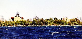
The Devils Island Lighthouse is a lighthouse located on Devils Island, one of the Apostle Islands, in Lake Superior in Ashland County, Wisconsin, near the city of Bayfield.

Kenosha Light is a lighthouse and keeper's house on Simmons Island north of the channel into Kenosha's harbor in Kenosha County, Wisconsin, USA.

The Kenosha North Pier lighthouse or Kenosha Light is a lighthouse located near Kenosha in Kenosha County, Wisconsin. "A typical 'Lake Michigan red tower'", it is a sibling to the Milwaukee Pierhead Light. This light was built in 1906 as a replacement for the old Kenosha Light. It was listed on the National register of Historic Places in 2008.

The Baileys Harbor Range Lights are a pair of lighthouses arranged in a range light configuration, located near Baileys Harbor in Door County, Wisconsin, United States.

The Baileys Harbor lighthouse is a lighthouse located near Baileys Harbor in Door County, Wisconsin.

The Chambers Island lighthouse is a lighthouse located on Chambers Island in Door County, Wisconsin. It was replaced in 1961 by a skeletal tower, visible for 12 nautical miles. The new light is identified by the USCG as 7-21895.

The Eagle Bluff Light, also known as Eagle Bluff lighthouse, or simply Eagle Bluff, is a lighthouse located near Ephraim in Peninsula State Park in Door County, Wisconsin. Construction was authorized in 1866, but the lighthouse was not actually built until 1868 at a cost of $12,000. It was automated in 1926. Restoration work began on the Eagle Bluff Light in 1960 and was completed in 1963, upon completion the Lighthouse was opened for tours. The lighthouse was added to the National Register of Historic Places in 1970.

The Plum Island Range Lights are a pair of range lights located on Plum Island in Door County, Wisconsin. They were part of the Plum Island United States Life-Saving Station. Plum Island was transferred to the United States Fish and Wildlife Service in 2007 and became part of the Green Bay National Wildlife Refuge. The life-saving station was listed on the National Register of Historic Places in 2010. Plum Island is seasonally open to the public for day-time use.
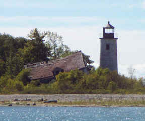
The Pilot Island Light is a lighthouse located near Gills Rock, on Pilot Island at the east end of Death's Door passage, in Door County, Wisconsin.

The Algoma Light or Algoma Pierhead Light is a lighthouse located near Algoma in Kewaunee County, Wisconsin.
Charity Island Light is a lighthouse on Big Charity Island in Lake Huron just off the coast of Au Gres, Northern Michigan.
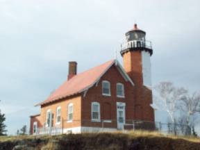
Eagle Harbor Light is an operational lighthouse at Eagle Harbor, in Keweenaw County in the state of Michigan. It sits on the rocky entrance to Eagle Harbor and is one of several light stations that guide mariners on Lake Superior across the northern edge of the Keweenaw Peninsula. The original lighthouse, built in 1851, was replaced in 1871 by the present red brick structure, which is a Michigan State Historic Site and listed on the National Register of Historic Places.

Wind Point Lighthouse is a lighthouse located at the north end of Racine Harbor in the U.S. state of Wisconsin. It is in the village of Wind Point, Wisconsin, on Lighthouse Road, next to the Shoop Park golf course. The lighthouse stands 108 feet (33 m) tall. One of the oldest and tallest active lighthouses on the Great Lakes, it was listed on the National Register of Historic Places in 1984.

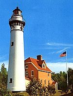
Au Sable Light is an active lighthouse in the Pictured Rocks National Lakeshore west of Grand Marais, Michigan off H-58. Until 1910, this aid to navigation was called "Big Sable Light".
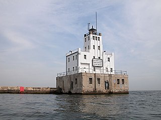
The Milwaukee Breakwater lighthouse was built in 1926 in the harbor of Milwaukee in Milwaukee County, Wisconsin to mark the entrance to the harbor. One of the last fully enclosed breakwater lighthouses in the Great Lakes, the structure was placed on the National Register of Historic Places in 2011.

The Kevich Light is a lighthouse located in the town of Grafton, Wisconsin.

The North Point Lighthouse Museum is a lighthouse built in 1888 in Lake Park on the East Side of Milwaukee in Milwaukee County, Wisconsin, United States to mark the entrance to the Milwaukee River. The lighthouse was added to the National Register of Historic Places in 1984. It was also added to the Library of Congress Historic American Buildings Survey as survey HABS WI-358.

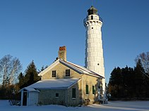
The Door County Maritime Museum is an American maritime museum located in Sturgeon Bay, Wisconsin, with additional sites in Gills Rock, Wisconsin, and the Cana Island Light.

 Lighthouse in December
 Lighthouse and oil house in February
 The privy is at the far right; taken in October
 Stairs in the tower
 Iron plating on the tower
 A lit beacon
 Lighthouse diagrams
 Tower diagram
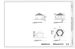 Oil house diagrams
 Privy diagrams
 Residence diagrams and light diagrams
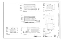 Shed diagrams