The Pecatonica River is a tributary of the Rock River, 194 miles (312 km) long, in southern Wisconsin and northern Illinois in the United States.

The Wisconsin Department of Natural Resources (WDNR) is a government agency of the U.S. state of Wisconsin charged with conserving and managing Wisconsin's natural resources. The Wisconsin Natural Resources Board has the authority to set policy for the WDNR. The WDNR is led by the Secretary, who is appointed by the Governor of Wisconsin. The WDNR develops regulations and guidance in accordance with laws passed by the Wisconsin Legislature. It administers wildlife, fish, forests, endangered resources, air, water, waste, and other issues related to natural resources. The central office of the WDNR is located in downtown Madison, near the state capitol.
Mazo Beach is the colloquial name for Mazomanie Bottoms State Natural Area, located in Sauk County in the U.S. state of Wisconsin. Property along the river was acquired in parcels by the State of Wisconsin since the 1950s to provide a full range of nature based activities including hiking, wildlife viewing, hunting, fishing, and wildlife habitat. Since 1978, the beach and surrounding nature preserve have attracted picnickers and swimming day-trippers to its open and expansive shoreline.
The Mead Wildlife Area is a state wildlife area covering over 33,000 acres (130 km2) in central Wisconsin. It includes portions of Marathon, Portage, and Wood counties. It is managed by the Wisconsin Department of Natural Resources (WDNR). The Area is commonly referred to as "the Mead". Five WDNR staff manage the Area. The non-profit organization Friends of the Mead/McMillan Association, Inc. assist with raising funds to support the area's activities.
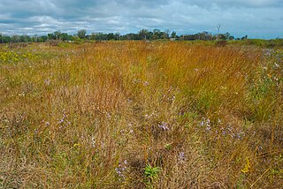
Chiwaukee Prairie is a 485-acre (1.96 km2) prairie in Pleasant Prairie, Wisconsin managed by the Wisconsin Department of Natural Resources. It is located on Lake Michigan at the Illinois state line and includes grassy wetlands, wooded areas, and the Kenosha Sand Dunes at its northern tip. It is home to an abundance of wildlife. It was designated a Wisconsin State Natural Area in 1967 and a National Natural Landmark in 1973.
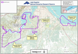
The Lake Superior National Estuarine Research Reserve includes land and water areas along the St. Louis River and Lake Superior in Douglas County, in the northwest corner of Wisconsin, United States. It is one of 29 National Estuarine Research Reserves. The Reserve is operated as a program of the Natural Resources Institute of the University of Wisconsin-Madison Division of Extension. It has an area of 16,697 acres (6,757 ha), and was designated in 2010.
The Gardner Swamp Wildlife Area is a 1,180 acres (480 ha) tract of protected land located in Door County, Wisconsin, managed by the Wisconsin Department of Natural Resources. Land to be used for the Wildlife Area was first acquired in 1958, and the master plan for the Wildlife Area was completed in 1980.

The Powell Marsh Wildlife Area is a 4,850-acre (19.6 km2) tract of protected land located in Vilas and Iron counties, Wisconsin, owned and partially managed by the Wisconsin Department of Natural Resources (WDNR). The nearby Dead Pike Lake has drawn attention to the wildlife area from conservators and homeowners nearby due to surface and groundwater flows shared between the two, with man-made structures in the latter harming the water quality of the lake.
The Swan Lake Wildlife Area is a 2,466 acres (998 ha) tract of protected land located in Columbia County, Wisconsin, managed by the Wisconsin Department of Natural Resources (WDNR). Land to be used for the wildlife area was first acquired in 1963 to provide for hunting and other outdoor recreational activities in the county. In addition to outdoor recreation activities, the wildlife area was established to protect the Fox River watershed.

The French Creek Wildlife Area is a 3,506 acres (1,419 ha) tract of protected land located in Columbia County and Marquette County, Wisconsin, managed by the Wisconsin Department of Natural Resources (WDNR). Land to be used for the wildlife area was first acquired in 1947 to provide for increased production of wildfowl and hunting opportunities. Prior to 1947, the area was used for the cultivation of wire grass which is used for the creation of grass rugs and mats.
The Big Beaver Creek Wildlife Area is a 572-acre (231 ha) tract of protected land located in Dunn County, Wisconsin, managed by the Wisconsin Department of Natural Resources (WDNR). Land to be used for the wildlife area was first acquired in 1959 to provide access to the Big Beaver Creek and Little Beaver Creek, along with the associated wetlands complex. The other major goal was to open up the area to state-sponsored timber harvesting, specifically that of tamarack.
The Vernon Wildlife Area is a 5,967-acre (2,415 ha) tract of protected land located in Waukesha County, Wisconsin, managed by the Wisconsin Department of Natural Resources (WDNR). The first parcel of land to be used for the Wildlife Area was leased in 1946 to function as a public hunting ground, focusing primarily on small game and various game birds. The Vernon Wildlife Area is one of ten state protected areas included in the Southern Kettle Moraine Region Planning Group, a WDNR classified area.
The Amsterdam Sloughs Wildlife Area is a 5,052-acre (2,044 ha) tract of protected land located in Burnett County, Wisconsin, managed by the Wisconsin Department of Natural Resources (WDNR). The Amsterdam Sloughs Wildlife Area is one of three such wildlife areas within the bounds of the Glacial Lake Grantsburg project, the others being Crex Meadows and Fish Lake.

Blomberg Lake and Woods State Natural Area is a Wisconsin Department of Natural Resources-designated State Natural Area made up of 966 acres (391 ha) of land. The state natural area is named after the 68 acres (28 ha) bog lake in the center of the protected area. The area is rich in plant life such as; sphagnum moss, cranberry, tawny cottongrass, pod-grass, three-way sedge and multiple trees such as aspen, speckled alder, black spruce, and red maple.

The Albany Wildlife Area(AWA) is a 2,007 acres (812 ha) tract of protected land located in Green County, Wisconsin, managed by the Wisconsin Department of Natural Resources (WDNR). Lands to be included in the wildlife area were first purchased in 1945 with the intention of them being used for inclusion in a new public area dedicated to hunting opportunities and conservation of indigenous species. That wildlife area was activated in 1956 as a Federal Aid Fish and Wildlife Restoration Project.
The Amberg Wildlife Area (AWA) is a 1,190-acre (480 ha) tract of protected land located in Marinette County, Wisconsin, managed by the Wisconsin Department of Natural Resources (WDNR). The wildlife area is surrounded by other protected areas, operated by either the county or other WDNR lands. The property was established in 1948, primarily to protect rare swamp conifer land, made up of 90-100 year old white cedar. The wildlife area is split up into two land management areas, the 909-acre (368 ha) native community management area of the Amberg Swamp Conifers and the eponymous 299-acre (121 ha) habitat management area.

Cylon Wildlife Area is a tract of protected land located in the northeastern corner of St. Croix County, Wisconsin, managed by the Wisconsin Department of Natural Resources (WDNR). The wildlife area presents a unique opportunity to preserve the last public land in St. Croix County.
The Balsam Branch Wildlife Area is a 180 acres (73 ha) tract of protected land in central Polk County, Wisconsin, managed by the Wisconsin Department of Natural Resources (WDNR). The wildlife area is characterized by marshland, prairie fields, and a pond set in the center of the property.
The Beaver Brook Wildlife Area is a 1,968-acre (7.96 km2) tract of protected land located in Washburn County, Wisconsin, managed by the Wisconsin Department of Natural Resources (WDNR). The wildlife area is in place to protect trout stream habitats and provide recreation experiences through its many trails.