
The Mountains-to-Sea State Trail (MST) is a long-distance trail for hiking and backpacking, that traverses North Carolina from the Great Smoky Mountains to the Outer Banks. The trail's western endpoint is at Clingman's Dome, where it connects to the Appalachian Trail in the Great Smoky Mountains National Park. Its eastern endpoint is in Jockey's Ridge State Park on the tallest sand dune on the east coast. The trail is envisioned as a scenic backbone of an interconnected trail system spanning the state. As such, the trail's route attempts to connect as many trail systems and natural scenic areas as practicable. A little over half of the trail is complete in multiple segments across the state.
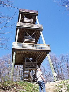
The Kettle Moraine State Forest is a state forest in southeastern Wisconsin. The chief feature of the reserve is the Kettle Moraine, a highly glaciated area. The area contains very hilly terrain and glacial landforms, such as kettles, kames and eskers. The 56,000-acre (23,000 ha) forest is divided into two large and three small units, which are spread across a hundred miles.

Ludington State Park is a public recreation area located two miles north of Ludington, Michigan, occupying 5,300 acres (2,100 ha) between the shores of Lake Michigan and Hamlin Lake. The state park is crossed by a one-mile stretch of the Big Sable River and is home to the 112-foot-high (34 m) Big Sable Point Lighthouse, which dates from 1876.

Sleepy Hollow State Park is a public recreation area covering 2,678 acres (1,084 ha) in the townships of Ovid and Victor in Clinton County, Michigan. The state park is located off US-127 nine miles southeast of St. Johns and four miles northwest of Laingsburg and centers on man-made, 410-acre (170 ha) Lake Ovid.
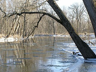
Tippecanoe River is a state park in Pulaski County, Indiana, United States. It is located 58 miles (93 km) south-southwest of South Bend, Indiana. It was formed in 1943 when the National Park Service gifted the land to Indiana's Department of Conservation land to form a state park; other land along the river becoming the Winamac Fish and Wildlife Area.

Sam A. Baker State Park is a public recreation area encompassing 5,323 acres (2,154 ha) in the Saint Francois Mountains region of the Missouri Ozarks. The state park offers fishing, canoeing, swimming, camping, and trails for hiking and horseback riding. The visitor and nature center is housed in a historic building that was originally constructed as a stable in 1934.

Capital Springs State Recreation Area is a state park unit of Wisconsin, United States, in development just south of Madison. The total area of the park is 3,000 acres (1,200 ha), with 326 acres (132 ha) designated as a state park. The park was authorized in 2000, the centennial of the Wisconsin state park system. The park includes 3,700 feet (1,100 m) of undeveloped shoreline on Lake Waubesa. The recreation area incorporates existing Dane County parks, and the site will be jointly managed by the state and the county. The property includes Native American archaeological sites that were listed on the National Register of Historic Places in 1978 as Lake Farms Archaeological District.

Proud Lake State Recreation Area is a state-managed public park and recreation area located in Commerce Township, Oakland County, Michigan, near Wixom. It is under the jurisdiction of the Michigan Department of Natural Resources. The recreation area has a total area of 3,030 acres (12.3 km2) and offers various outdoor activities including 20 miles (32 km) of hiking trails, cross-country skiing, fishing in the Huron River, hunting, canoeing, and picnicking. A campground has 130 campsites and a 24-person cabin for rent.

Kickapoo State Recreation Area is an Illinois state park on 2,842 acres (1,150 ha) in Vermilion County, Illinois, United States. Located between Oakwood, Illinois and Danville, Illinois, this park is easily accessible through route I-74. It is 28 miles (45 km) away from the University of Illinois at Urbana-Champaign and 95 miles (153 km) from Indianapolis. According to the Illinois Department of Natural Resources, the name Kickapoo originated from the Kickapoo village that once existed near the junction of the Salt Fork and Middle Fork branches of the Vermilion River. After Europeans settled in the area and displaced the Native Americans, the Europeans began to dig wells to harvest salt from salt springs, called salines. In the early 20th century the land was then strip-mined for coal. Kickapoo State Park was the first park in the United States to be located on strip-mined land. The state of Illinois purchased the Kickapoo State Park Area in 1939 with donation money from Danville residents and the land has since recovered from the extraction of these resources.

Pinckney State Recreation Area is a Michigan state recreation area in Dexter, Sylvan and Lyndon Townships, Washtenaw County and Putnam and Unadilla Townships, Livingston County in the U.S. state of Michigan. The park is 11,000 acres (4,500 ha) and sits at an elevation of 922 feet (281 m). The park is connected to the nearby Waterloo State Recreation Area by the 35-mile (56 km) Waterloo–Pinckney Trail. Pinckney State Recreation Area is open for year-round recreation including hiking, fishing, swimming, hunting and a variety of winter sports.
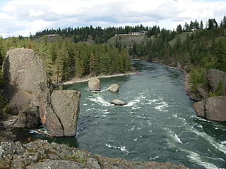
Riverside State Park is a Washington state park located 9 miles (14 km) northwest of Spokane in the community of Nine Mile Falls. The park protects 11,162 acres (4,517 ha) of Okanagan dry forest along the Spokane and Little Spokane rivers. It is the second largest state park in Washington after Mount Spokane State Park and is a popular recreation area for locals.
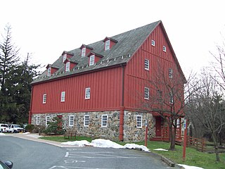
Gunpowder Falls State Park is a public recreation area comprising six non-contiguous areas covering 18,000 acres (7,300 ha) in northeastern Baltimore County and western Harford County, Maryland. The state park is primarily made up of the stream valleys of the Big and Little Gunpowder Falls and the Gunpowder River; its natural features range from tidal marshes to rugged interior slopes. The park has over 120 miles of trails for hiking, biking, horseback riding, and cross-country skiing plus facilities for picnicking, tubing, canoeing and kayaking, tide-water fishing and crabbing, fly fishing, and hunting, among other activities. It is managed by the Maryland Department of Natural Resources.

Kohler-Andrae State Park comprises two adjacent Wisconsin state parks located in the Town of Wilson, a few miles south of the city of Sheboygan. They are managed as one unit. Terry Andrae State Park, established in 1927, and John Michael Kohler State Park, established in 1966, total 988 acres (4.00 km2). The parks contain over two miles (3 km) of beaches and sand dunes along the shore of Lake Michigan, with woods and wetlands away from the water. The Black River flows through the parks.

Potawatomi State Park is a 1,225-acre (496 ha) Wisconsin state park northwest of the city of Sturgeon Bay, Wisconsin in the Town of Nasewaupee. It is located in Door County along Sturgeon Bay, a bay within the bay of Green Bay. Potawatomi State Park was established in 1928.

Big Run State Park is a public recreation area located at the northern end of the Savage River Reservoir, an impoundment of the Savage River, in Garrett County, Maryland. The state park occupies 300 acres (120 ha) in Savage River State Forest and encompasses the confluence of Monroe Run and Big Run. Park activities include boating, fishing, hiking, picknicking, and camping.

Island Lake State Recreation Area is a state-run park in Green Oak Township, Livingston County, in metro Detroit in Michigan. The 4,000-acre (1,600 ha) park lies on the Huron River just downstream of Kensington Metropark with which it is also connected by a bike trail. It is the third busiest park operated by the Michigan Department of Natural Resources with visitation of 1.09 million in 2008. The park is easily accessed as it lies near the intersection of I-96 and US-23. The park has a group campsite and a canoe-in campsite, several miles of hiking and biking trails, a shooting range, swimming and a couple of small lakes. It is the only Michigan park to have a hot air balloon launch area.
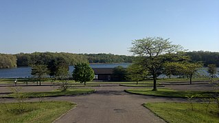
Holly State Recreation Area is a state recreation area in Groveland Township, near Holly, Michigan.

Deam Lake State Recreation Area is an Indiana State Recreation Area in Clark County, Indiana in the United States. The park is 1,300 acres (530 ha) and sits at an elevation of 535 feet (163 m). Deam Lake State Recreation area is open for year-round recreation, however the campground closes each year from the Sunday before Thanksgiving to March 1 of the following year. Much of the recreation is centered on Deam Lake. It is named for Charles C. Deam, the first state forester of Indiana.

Menominee River State Recreation Area is a state-managed protected area located in Breitung and Norway townships in Dickinson County and Faithorn Township in Menominee County, Michigan, southeast of Iron Mountain. It is 2,354 acres (953 ha) in area and is currently undeveloped. The park comprises a 145.35-acre (58.82 ha) tract along 1.5 miles (2.4 km) of the Menominee River south of the City of Norway and the 2,208.83-acre (893.88 ha) Quiver Falls Tract along eight miles (13 km) of the river farther downstream. In 2016, an additional 525-acre (212 ha) of Escanaba State Forest land was transferred from the Forestry Division to the DNR's Parks and Recreation Division and became the Pemene Falls Unit of the park, matching a similarly-named unit on the Wisconsin side of the river.

Lime Island State Recreation Area is a 980 acres (400 ha) undeveloped state park in the U.S. state of Michigan. The recreation area is located on Lime Island in the St. Marys River near its mouth. The park has no facilities except 5 primitive boat-in campsites. The park was purchased in 1982 and managed by the state's Forest Management Division until it was transferred to the Parks Department in 2011, becoming the 99th park unit. Lime Island contains historic sites from its history as summer camps of Woodland Indians, a lime kiln site, ship bunkering site, and a resort. Lime Island was one of the state forest campgrounds slated to be shut down due to funding cuts until it was transferred to the park program.


