Niagara (town), Wisconsin

Last updated
Niagara, Wisconsin
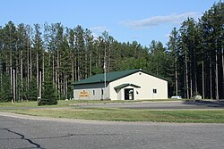
NiagaraTownWisconsinTownHallUS8.jpg
Town hall nestled in the forest typical of the town
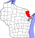
WIMap-doton-Niagara.png
Location of Niagara, Wisconsin
Coordinates: 45°43′39″N87°57′14″W / 45.72750°N 87.95389°W / 45.72750; -87.95389 Coordinates: 45°43′39″N87°57′14″W / 45.72750°N 87.95389°W / 45.72750; -87.95389
Country Flag of the United States.svg  United States
State Flag of Wisconsin.svg  Wisconsin
County Marinette
Area
  Total68.4 sq mi (177.0 km2)
  Land67.1 sq mi (173.8 km2)
  Water1.3 sq mi (3.2 km2)
Elevation
[1]
1,024 ft (312 m)
Population
 (2000)
  Total924
  Density13.8/sq mi (5.3/km2)
Time zone UTC-6 (Central (CST))
  Summer (DST) UTC-5 (CDT)
Area code(s) 715 & 534
FIPS code 55-57350 [2]
GNIS feature ID1583820 [1]

Niagara is a town in Marinette County, Wisconsin, United States. The population was 924 at the 2000 census. The city of Niagara is located to the north of and adjacent to the town.

Contents

Geography

According to the United States Census Bureau, the town has a total area of 68.4 square miles (177.1 km2), of which, 67.1 square miles (173.8 km2) of it is land and 1.2 square miles (3.2 km2) of it (1.83%) is water.

Demographics

As of the census [2] of 2000, there were 924 people, 348 households, and 263 families residing in the town. The population density was 13.8 people per square mile (5.3/km2). There were 453 housing units at an average density of 6.8 per square mile (2.6/km2). The racial makeup of the town was 98.16% White, 0.32% Black or African American, 0.32% Native American, 0.43% Asian, 0.32% from other races, and 0.43% from two or more races. 1.08% of the population were Hispanic or Latino of any race.

There were 348 households, out of which 37.4% had children under the age of 18 living with them, 68.1% were married couples living together, 3.4% had a female householder with no husband present, and 24.4% were non-families. 19.5% of all households were made up of individuals, and 8.0% had someone living alone who was 65 years of age or older. The average household size was 2.66 and the average family size was 3.09.

In the town, the population was spread out, with 28.8% under the age of 18, 5.6% from 18 to 24, 30.2% from 25 to 44, 23.5% from 45 to 64, and 11.9% who were 65 years of age or older. The median age was 38 years. For every 100 females, there were 108.6 males. For every 100 females age 18 and over, there were 106.3 males.

The median income for a household in the town was $40,250, and the median income for a family was $50,347. Males had a median income of $41,719 versus $32,250 for females. The per capita income for the town was $17,504. About 5.2% of families and 6.4% of the population were below the poverty line, including 7.5% of those under age 18 and 6.1% of those age 65 or over.

Related Research Articles

<span class="mw-page-title-main">Argo, Alabama</span> Town in Alabama, United States

Argo is a town in Jefferson and St. Clair counties, Alabama, United States. It incorporated in 1987. At the 2020 census, the population was 4,368.

<span class="mw-page-title-main">Hersey, Maine</span> Town in the state of Maine, United States

Hersey is a town in Aroostook County, Maine, United States. The population was 73 at the 2020 census.

Kenduskeag is a town in Penobscot County, Maine, United States. The population was 1,346 at the 2020 census.

Palmyra is a town in Somerset County, Maine, United States. The population was 1,924 at the 2020 census.

<span class="mw-page-title-main">Deer Creek Township, Otter Tail County, Minnesota</span> Township in Minnesota, United States

Deer Creek Township is a township in Otter Tail County, Minnesota, United States. The population was 348 at the 2000 census.

<span class="mw-page-title-main">Grey Eagle, Minnesota</span> City in Minnesota, United States

Grey Eagle is a city in Todd County, Minnesota, United States. The population was 348 at the 2010 census.

<span class="mw-page-title-main">Middleport, New York</span> Village in New York, United States

Middleport is a village in Niagara County, New York, United States. The population was 1,840 at the 2010 census. The mail ZIP code is 14105. It is part of the Buffalo–Niagara Falls Metropolitan Statistical Area.

<span class="mw-page-title-main">Niagara, North Dakota</span> City in North Dakota, United States

Niagara is a city in Grand Forks County, North Dakota, United States. It is part of the "Grand Forks, ND-MN Metropolitan Statistical Area" or "Greater Grand Forks". The population was 46 at the 2020 census. Niagara was founded in 1883.

<span class="mw-page-title-main">Elmhurst Township, Lackawanna County, Pennsylvania</span> Place in Pennsylvania, United States

Elmhurst Township is a township in Lackawanna County, Pennsylvania, United States. The population was 836 at the 2020 census.

<span class="mw-page-title-main">Blythe Township, Schuylkill County, Pennsylvania</span> Township in Pennsylvania, United States

Blythe Township is a township in Schuylkill County, Pennsylvania. Formed in 1846 from part of Schuylkill Township, it is named for State Legislator Calvin Blythe.

<span class="mw-page-title-main">North Codorus Township, York County, Pennsylvania</span> Township in Pennsylvania, United States

North Codorus Township is a township in York County, Pennsylvania, United States. The population was 9,149 at the 2020 census.

<span class="mw-page-title-main">Riverside, Washington</span> Town in Washington, United States

Riverside is a town in Okanogan County, Washington, United States. The population was 348 at the 2000 census and decreased to 280 at the 2010 census.

<span class="mw-page-title-main">Flatwoods, West Virginia</span> Town in West Virginia, United States

Flatwoods is a town in Braxton County, West Virginia, United States, located approximately one mile from exit 67 of Interstate 79.

<span class="mw-page-title-main">Levis, Wisconsin</span> Town in Wisconsin, United States

Levis is a town in Clark County in the U.S. state of Wisconsin. The population was 504 at the 2000 census.

<span class="mw-page-title-main">Pella, Wisconsin</span> Town in Wisconsin, United States

Pella is a town in Shawano County, Wisconsin, United States. The population was 877 at the 2000 census. The unincorporated community of Leopolis is located partially within the town. There is a census-designated place also called Pella in the town.

<span class="mw-page-title-main">La Grange, Walworth County, Wisconsin</span> Town in Wisconsin, United States

La Grange is a town in Walworth County, Wisconsin, United States. The population was 2,472 at the 2020 census. The unincorporated communities of Heart Prairie, La Grange, Lauderdale, Lauderdale Lakes, and Lauderdale Shores are located in the town.

<span class="mw-page-title-main">Leon, Waushara County, Wisconsin</span> Town in Wisconsin, United States

Leon is a town in Waushara County, Wisconsin, United States. The population was 1,281 at the 2000 census. The census-designated place of Pine River is located in the town. The village of Redgranite is located adjacent to the town.

<span class="mw-page-title-main">Holland (CDP), New York</span> Census-designated place in New York, United States

Holland is a hamlet and census-designated place (CDP) in Erie County, New York, United States. The population was 1,206 at the 2010 census. It is in the town of Holland and is part of the Buffalo–Niagara Falls Metropolitan Statistical Area.

<span class="mw-page-title-main">Newfane (CDP), New York</span> CDP in New York, United States

Newfane is a census-designated place (CDP) in the town of Newfane in Niagara County, New York, United States, along State Route 78. The population was 3,822 at the 2010 census. It is part of the Buffalo–Niagara Falls Metropolitan Statistical Area.

<span class="mw-page-title-main">Niagara, Wisconsin</span> City in Wisconsin, United States

Niagara is a city in Marinette County, Wisconsin, United States. The population was 1,624 at the 2010 census. The city lies to the north of and adjacent to the Town of Niagara. It is part of the Marinette, WI–MI Micropolitan Statistical Area.

References

  1. 1 2 "US Board on Geographic Names". United States Geological Survey. 2007-10-25. Retrieved 2008-01-31.
  2. 1 2 "U.S. Census website". United States Census Bureau . Retrieved 2008-01-31.