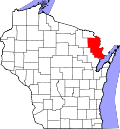
Wagner, Wisconsin

Last updated

Wagner, Wisconsin
Wagner WI USA - town hall.JPG
Wagner town hall
WIMap-doton-Wagner.png
Location of Wagner, Wisconsin
Coordinates: 45°18′22″N87°43′30″W / 45.30611°N 87.72500°W / 45.30611; -87.72500
Country Flag of the United States.svg  United States
State Flag of Wisconsin.svg  Wisconsin
County Marinette
Area
  Total54.6 sq mi (141.4 km2)
  Land53.2 sq mi (137.8 km2)
  Water1.4 sq mi (3.6 km2)
Elevation
[1]
705 ft (215 m)
Population
 (2000)
  Total722
  Density13.6/sq mi (5.2/km2)
Time zone UTC-6 (Central (CST))
  Summer (DST) UTC-5 (CDT)
FIPS code 55-83050 [2]
GNIS feature ID1584338 [1]

Wagner is a town in Marinette County, Wisconsin, United States. The population was 722 at the 2000 census. The unincorporated communities of Goll, McAllister, Packard, and Wagner are located in the town.

Contents

History

The Town of Wagner comprises numerous other settlements, including Bar, Goll, Kinsman, McAllister, Newton, Packard, and Wagner. Wagner was created in 1915, when residents east of Middle Inlet sought separation from Porterfield. The first county board supervisor was Joseph Wagner (1850–1925), whom the town is named after. [3]

Geography

Town of Wagner welcome sign Town of Wagner Marinette Co. Wisconsin - Welcome sign.jpg
Town of Wagner welcome sign

According to the United States Census Bureau, the town has a total area of 54.6 square miles (141.4 km2), of which, 53.2 square miles (137.8 km2) of it is land and 1.4 square miles (3.6 km2) of it (2.55%) is water.

Demographics

As of the census [2] of 2000, there were 722 people, 283 households, and 213 families residing in the town. The population density was 13.6 people per square mile (5.2/km2). There were 384 housing units at an average density of 7.2 per square mile (2.8/km2). The racial makeup of the town was 98.06% White, 0.42% Native American, 0.14% Asian, 0.55% from other races, and 0.83% from two or more races. Hispanic or Latino of any race were 0.28% of the population.

There were 283 households, out of which 31.1% had children under the age of 18 living with them, 68.2% were married couples living together, 4.6% had a female householder with no husband present, and 24.4% were non-families. 21.2% of all households were made up of individuals, and 10.6% had someone living alone who was 65 years of age or older. The average household size was 2.55 and the average family size was 2.98.

In the town, the population was spread out, with 25.3% under the age of 18, 6.2% from 18 to 24, 25.8% from 25 to 44, 27.3% from 45 to 64, and 15.4% who were 65 years of age or older. The median age was 40 years. For every 100 females, there were 110.5 males. For every 100 females age 18 and over, there were 111.4 males.

The median income for a household in the town was $39,792, and the median income for a family was $45,185. Males had a median income of $31,313 versus $20,446 for females. The per capita income for the town was $15,165. About 4.1% of families and 4.8% of the population were below the poverty line, including 6.8% of those under age 18 and 8.5% of those age 65 or over.

Related Research Articles

<span class="mw-page-title-main">Marinette County, Wisconsin</span> County in Wisconsin, United States

Marinette County is a county in the U.S. state of Wisconsin. As of the 2020 census, the population was 41,872. Its county seat is Marinette. Marinette County is part of the Marinette, WI–MI Micropolitan Statistical Area.

<span class="mw-page-title-main">Grimes, Alabama</span> Town in Alabama, United States

Grimes is a town in Dale County, Alabama, United States. At the 2010 census the population was 558, up from 459 in 2000. It is part of the Enterprise–Ozark Micropolitan Statistical Area.

<span class="mw-page-title-main">Pisgah, Alabama</span> Town in Alabama, United States

Pisgah is a town in Jackson County, Alabama, United States, and is included in the Huntsville-Decatur Combined Statistical Area. It incorporated in 1947. As of the 2020 census, the population of the town was 681, down from 722 in 2010. Pisgah is located atop Sand Mountain.

<span class="mw-page-title-main">Sylvan Springs, Alabama</span> Town in Alabama, United States

Sylvan Springs is a town in Jefferson County, Alabama, United States, located northwest of the Birmingham suburb of Pleasant Grove. It incorporated on May 22, 1957. At the 2010 census the population was 1,542, up from 1,465 in 2000. This area was damaged by an F5 tornado on April 8, 1998, including the First United Methodist Church of Sylvan Springs.

<span class="mw-page-title-main">Moore, Idaho</span> City in Idaho, United States

Moore is a city in Butte County, Idaho, United States. The population was 162 at the 2020 census.

<span class="mw-page-title-main">Odon, Indiana</span> Town in Indiana, United States

Odon is a town in Madison Township, Daviess County, Indiana, United States. The population was 1,354 at the 2010 census.

<span class="mw-page-title-main">Glenwood, Indiana</span> Town in Indiana, United States

Glenwood is a town in Union Township, Rush County and in Orange and Fairview townships, Fayette County in the U.S. state of Indiana. The population was 250 at the 2010 census.

<span class="mw-page-title-main">Veazie, Maine</span> Town in the state of Maine, United States

Veazie is a town in Penobscot County, Maine, United States. The population was 1,814 at the 2020 census. The town is named after General Samuel Veazie, an early lumber baron and railroad operator. Veazie was originally part of Bangor, using Penobscot River water power to operate sawmills. It became a separate town in 1853 because Gen. Veazie, its wealthiest citizen, thought Bangor's property taxes were too high.

Topsfield is a town in Washington County, Maine, United States. The population was 179 at the 2020 census.

<span class="mw-page-title-main">Lake Bronson, Minnesota</span> City in Minnesota, United States

Lake Bronson is a city in Kittson County, Minnesota, United States. The population was 178 at the 2020 census. Lake Bronson State Park is nearby.

<span class="mw-page-title-main">Gerry, New York</span> Town in New York, United States

Gerry is a town in Chautauqua County, New York, United States. The population was 1,789 at the 2020 census. The town is named after Elbridge Gerry, the fifth Vice President of the United States. The town is centrally located in the county and is north of Jamestown.

<span class="mw-page-title-main">Taylortown, North Carolina</span> Town in North Carolina, United States

Taylortown is a town in Moore County, North Carolina, United States. The population was 722 as of the 2010 census. It is bordered by nearby Pinehurst.

<span class="mw-page-title-main">Wagner, South Dakota</span> City in South Dakota, United States

Wagner is a city in Charles Mix County, South Dakota, United States. The population was 1,490 at the 2020 census. The city is served by Wagner Municipal Airport as well as YST Transit buses.

<span class="mw-page-title-main">Ethridge, Tennessee</span> Town in Tennessee, United States

Ethridge is a town in Lawrence County, Tennessee, United States. The population was 465 at the 2010 census, down from 536 at the 2000 census.

<span class="mw-page-title-main">Briaroaks, Texas</span> City in Texas, United States

Briaroaks is a city in Johnson County, Texas, United States. The population was 507 at the 2019 census estimates.

<span class="mw-page-title-main">La Sal, Utah</span> CDP in Utah, United States

La Sal is a census-designated place (CDP) in northeastern San Juan County, Utah, United States. The population was 339 at the 2000 census. The name comes from the La Sal Mountains which means in Spanish "The Salt". The area is known for its uranium resources.

<span class="mw-page-title-main">Bancroft, West Virginia</span> Town in West Virginia, United States

Bancroft is a town in Putnam County, West Virginia, United States, along the Kanawha River. The population was 389 at the 2020 census. It is part of the Huntington–Ashland metropolitan area.

<span class="mw-page-title-main">Brandon, Wisconsin</span> Village in Wisconsin, United States

Brandon is a village in Fond du Lac County, Wisconsin, United States. The population was 879 at the 2010 census.

<span class="mw-page-title-main">Oak Grove, Pierce County, Wisconsin</span> Town in Wisconsin, United States

Oak Grove is a town in Pierce County, Wisconsin, United States. The population was 2,150 at the 2010 census.

<span class="mw-page-title-main">Pound (town), Wisconsin</span>

Pound is a town in Marinette County, Wisconsin, United States. The population was 1,367 at the 2000 census. The village of Pound is located within but politically independent of the town.

References

  1. 1 2 "US Board on Geographic Names". United States Geological Survey. October 25, 2007. Retrieved January 31, 2008.
  2. 1 2 "U.S. Census website". United States Census Bureau . Retrieved January 31, 2008.
  3. "Wagner Pioneer Is Dead". The Rhinelander Daily News. September 4, 1925. p. 6. Retrieved September 8, 2014 via Newspapers.com. Open Access logo PLoS transparent.svg

45°18′08″N87°44′08″W / 45.30222°N 87.73556°W / 45.30222; -87.73556