Wausaukee (town), Wisconsin

Last updated

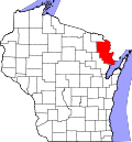
Wausaukee is a town in Marinette County, Wisconsin, United States. The estimated population was 573 in 2011. [1] The Village of Wausaukee is located within the town. The unincorporated community of Cedarville is located partially in the town.

Contents

Geography

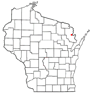
Location of Wausaukee (town), Wisconsin WIMap-doton-Wausaukee.png
Location of Wausaukee (town), Wisconsin

According to the United States Census Bureau, the town has a total area of 77.4 square miles (200.6 km2), of which, 75.7 square miles (196.1 km2) of it is land and 1.7 square miles (4.4 km2) of it (2.21%) is water.

The Wausaukee River flows through the town into the Menominee River. [2]

Demographics

As of the census [3] of 2000, there were 1,196 people, 469 households, and 354 families residing in the town. The population density was 15.8 people per square mile (6.1/km2). There were 1,036 housing units at an average density of 13.7 per square mile (5.3/km2). The racial makeup of the town was 98.49% White, 0.08% Black or African American, 0.33% Native American, 0.33% Asian, 0.08% from other races, and 0.67% from two or more races. 0.42% of the population were Hispanic or Latino of any race.

There were 469 households, out of which 30.1% had children under the age of 18 living with them, 65.9% were married couples living together, 6.4% had a female householder with no husband present, and 24.5% were non-families. 20.9% of all households were made up of individuals, and 9.8% had someone living alone who was 65 years of age or older. The average household size was 2.55 and the average family size was 2.93.

In the town, the population was spread out, with 25.9% under the age of 18, 3.8% from 18 to 24, 23.3% from 25 to 44, 31.3% from 45 to 64, and 15.7% who were 65 years of age or older. The median age was 43 years. For every 100 females, there were 101.7 males. For every 100 females age 18 and over, there were 105.1 males.

The median income for a household in the town was $35,530, and the median income for a family was $39,375. Males had a median income of $32,337 versus $20,476 for females. The per capita income for the town was $18,610. About 2.9% of families and 5.5% of the population were below the poverty line, including 2.2% of those under age 18 and 7.1% of those age 65 or over.

Related Research Articles

<span class="mw-page-title-main">Pomona Park, Florida</span> Town in the state of Florida, United States

Pomona Park is a town in Putnam County, Florida, United States. The population was 912 at the 2010 census and has gone up to 916 in the 2018 estimates. The town is part of the Palatka Micropolitan Statistical Area.

<span class="mw-page-title-main">Capron, Illinois</span> Village in Illinois, United States

Capron is a village in Boone County, Illinois, United States. It is part of the Rockford, Illinois Metropolitan Statistical Area. The population was 1395 at the 2020 census, up from 1,376 at the 2010 census.

<span class="mw-page-title-main">Center Point, Indiana</span> Town in Indiana, United States

Center Point is a town in Sugar Ridge Township, Clay County, Indiana, United States. The population was 242 at the 2010 census. It is part of the Terre Haute Metropolitan Statistical Area.

<span class="mw-page-title-main">Shadeland, Indiana</span> Town in Indiana, United States

Shadeland is a town in Union Township, Tippecanoe County, in the U.S. state of Indiana. The population was 1,610 at the 2010 census.

<span class="mw-page-title-main">Littleton, Maine</span> Town in the state of Maine, United States

Littleton is a town in Aroostook County, Maine, United States. The population was 997 at the 2020 census.

Plymouth is a town in Penobscot County, Maine, United States. The population was 1,325 at the 2020 census.

<span class="mw-page-title-main">Gilman, Minnesota</span> City in Minnesota, United States

Gilman is a city in Benton County, Minnesota, United States. The population was 224 at the 2010 census. It is part of the St. Cloud Metropolitan Statistical Area.

<span class="mw-page-title-main">Walnut, Mississippi</span> Town in Mississippi, United States

Walnut is a town in Tippah County, Mississippi, United States. The population was 771 at the 2010 census.

<span class="mw-page-title-main">Pettit, Oklahoma</span> Census-designated place in Oklahoma, United States

Pettit is an unincorporated community and census-designated place (CDP) in Cherokee County, Oklahoma, United States. The population was 954 at the 2010 census, a 23.7 percent increase over the figure of 771 recorded in 2000. The town was named for Mark and Eliza Pettit, townsite allottees.

<span class="mw-page-title-main">Belle, West Virginia</span> Town in West Virginia, United States

Belle is a town in Kanawha County, West Virginia, United States, situated along the Kanawha River. The population was 1,171 at the 2020 census. Belle was incorporated on December 13, 1958 by the Kanawha County Circuit Court. It is the home of the Belle Bulldogs Elementary School.

<span class="mw-page-title-main">Eaton, Brown County, Wisconsin</span> Town in Wisconsin, United States

Eaton is a town in Brown County in the U.S. state of Wisconsin. The population was 1,508 at the 2010 census. The unincorporated communities of Coppens Corner, Henrysville, and Poland are located in the town. The unincorporated community of Buckman is also located partially in the town.

<span class="mw-page-title-main">Forest, Fond du Lac County, Wisconsin</span> Town in Wisconsin, United States

Forest is a town in Fond du Lac County, Wisconsin, United States. The population was 1,108 at the 2000 census. The unincorporated communities of Banner, Dotyville, and Graham Corners are located in the town.

<span class="mw-page-title-main">Brigham, Wisconsin</span> Town in Wisconsin, United States

the Town of Brigham is a town located in Iowa County, Wisconsin, United States. The population was 908 at the 2000 census. The unincorporated community of Middlebury is located in the town.

<span class="mw-page-title-main">Athelstane, Wisconsin</span> Town in Wisconsin, United States

Athelstane is a town in Marinette County, Wisconsin, United States. The population was 601 at the 2000 census. The unincorporated community of Athelstane is located in the town.

<span class="mw-page-title-main">Martell, Wisconsin</span> Town in Wisconsin, United States

Martell is a town in Pierce County, Wisconsin, United States. The population was 1,070 at the 2000 census. The unincorporated communities of Martell and Morton Corner are located in the town. The unincorporated community of Lawton is also located partially in the town.

<span class="mw-page-title-main">Williams Creek, Indiana</span> Town in Indiana, United States

Williams Creek is a town in Washington Township, Marion County, Indiana, United States. It is located about 9 miles (14 km) north of downtown Indianapolis. The population was 430 at the 2020 census. It has existed as an "included town" since 1970, when it was incorporated into Indianapolis as part of Unigov. It is part of Indianapolis, but retains a functioning town government under IC 36-3-1-11.

Patch Grove is a village in Grant County, Wisconsin, United States. The population was 198 at the 2010 census. The village is located within the Town of Patch Grove.

<span class="mw-page-title-main">Luxemburg (town), Wisconsin</span>

Luxemburg is a town in Kewaunee County, Wisconsin, United States. The population was 1,469 at the 2010 census. The village of Luxemburg, a separate municipality, is surrounded by the town. The unincorporated communities of Walhain and Casco Junction are in the town, and Neuern, Frog Station, and Tonet are partially in the town.

<span class="mw-page-title-main">Pound (town), Wisconsin</span>

Pound is a town in Marinette County, Wisconsin, United States. The population was 1,367 at the 2000 census. The village of Pound is located within but politically independent of the town.

<span class="mw-page-title-main">Wausaukee, Wisconsin</span> Village in Wisconsin, United States

Wausaukee is a village in Marinette County, Wisconsin, in the United States. The population was 575 at the 2010 census. The village is part of the Marinette, WI–MI Micropolitan Statistical Area.

References

  1. "Population in the U.S." Retrieved January 17, 2013.
  2. "Report for: Wausaukee River". USGNIS. U.S. Department of the Interior. Retrieved March 16, 2021.
  3. "U.S. Census website". United States Census Bureau . Retrieved January 31, 2008.

45°23′52″N87°56′57″W / 45.39778°N 87.94917°W / 45.39778; -87.94917