Goll, Wisconsin

Last updated

Goll, Wisconsin
Goll Wisconsin 2.jpg
USA Wisconsin location map.svg
Red pog.svg
Goll, Wisconsin
Usa edcp location map.svg
Red pog.svg
Goll, Wisconsin
Coordinates: 45°16′49″N87°45′03″W / 45.28028°N 87.75083°W / 45.28028; -87.75083
Country Flag of the United States.svg  United States
State Flag of Wisconsin.svg  Wisconsin
County Marinette
Elevation
214 m (702 ft)
Time zone UTC-6 (Central (CST))
  Summer (DST) UTC-5 (CDT)
Area code(s) 715 & 534
GNIS feature ID1565617 [1]

Goll is an unincorporated community located in the town of Wagner, Marinette County, Wisconsin, United States. [1]

Contents

Geography

Goll Wisconsin.jpg
Goll, 1912 map detail
Goll Wisconsin - sign 2.jpg
Sign for Goll Road

Goll is located at the intersection of County Trunk Highway X and Old Rail Road (formerly Right of Way Road), [2] at an elevation of 702 feet (214 m). [1] It is connected by road to Wagner to the north, Middle Inlet to the west, and Wisconsin Highway 180 to the east. Goll Road runs obliquely to the east of the former rail line.

History

Goll was a stop between Miles and Wagner on the Wisconsin & Michigan (W. & M.) Railway line from Bagley Junction to Iron Mountain. [3] The rail line through Goll was discontinued in 1938, when the tracks were torn out and the rolling stock sold off. [3] [4] [5] A post office was established in Goll in the 1896, [6] and Edward Ashburton Lindsley (1869–1940) was appointed postmaster at Goll that year, replacing H. S. Brooks. [7] The post office in Goll was closed in 1913. [6]

Related Research Articles

<span class="mw-page-title-main">Marinette County, Wisconsin</span> County in Wisconsin, United States

Marinette County is a county in the U.S. state of Wisconsin. As of the 2020 census, the population was 41,872. Its county seat is Marinette. Marinette County is part of the Marinette, WI–MI Micropolitan Statistical Area.

<span class="mw-page-title-main">Menominee, Michigan</span> City in Michigan, United States

Menominee is a city in the Upper Peninsula of the U.S. state of Michigan. The population was 8,488 at the 2020 census. It is the county seat of Menominee County. Menominee is the fourth-largest city in the Upper Peninsula, behind Marquette, Sault Ste. Marie, and Escanaba. Menominee Township is located to the north of the city, but is politically autonomous.

<span class="mw-page-title-main">Marinette, Wisconsin</span> City in Wisconsin, United States

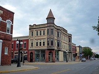
Marinette is a city in and the county seat of Marinette County, Wisconsin, United States. It is located on the south bank of the Menominee River, at its mouth at Green Bay, part of Lake Michigan; to the north is Stephenson Island, part of the city preserved as park. During the lumbering boom of the late 19th century, Marinette became the tenth-largest city in Wisconsin in 1900, reaching a peak population of 16,195.

<span class="mw-page-title-main">Wagner, Wisconsin</span> Town in Wisconsin, United States

Wagner is a town in Marinette County, Wisconsin, United States. The population was 722 at the 2000 census. The unincorporated communities of Goll, McAllister, Packard, and Wagner are located in the town.

<span class="mw-page-title-main">Middle Inlet (community), Wisconsin</span> Unincorporated community in Wisconsin, United States

Middle Inlet is an unincorporated community in Marinette County, Wisconsin (USA), in the town of Middle Inlet.

<span class="mw-page-title-main">Walsh, Wisconsin</span> Unincorporated community in Wisconsin, United States

Walsh is an unincorporated community located in the town of Porterfield, in Marinette County, Wisconsin, United States.

<span class="mw-page-title-main">Porterfield (community), Wisconsin</span> Unincorporated community and Census-designated place in Wisconsin, United States

Porterfield is a census-designated place in the town of Porterfield, Marinette County, Wisconsin, United States.

<span class="mw-page-title-main">Rubys Corner, Wisconsin</span> Unincorporated community in Wisconsin, United States

Rubys Corner is an unincorporated community located in the town of Porterfield, Marinette County, Wisconsin, United States.

Packard is an unincorporated community located in the town of Wagner, Marinette County, Wisconsin, United States.

Loomis is an unincorporated community located in the town of Lake, Marinette County, Wisconsin, United States.

McAllister is an unincorporated community located in the town of Wagner, Marinette County, Wisconsin, United States.

<span class="mw-page-title-main">May Corner, Wisconsin</span> Unincorporated community in Wisconsin, United States

May Corner is an unincorporated community located in the town of Grover, Marinette County, Wisconsin, United States.

Harmony is an unincorporated community located in the town of Grover, Marinette County, Wisconsin, United States. Harmony is located 5 miles (8.0 km) northwest of Peshtigo.

<span class="mw-page-title-main">Bagley Junction, Wisconsin</span> Unincorporated community in Wisconsin, United States

Bagley Junction is an unincorporated community located in the town of Porterfield, Marinette County, Wisconsin, United States.

<span class="mw-page-title-main">Miles, Wisconsin</span> Unincorporated community in Wisconsin, United States

Miles is an unincorporated community located in the town of Porterfield, Marinette County, Wisconsin, United States.

<span class="mw-page-title-main">Wagner (community), Wisconsin</span> Unincorporated community in Wisconsin, United States

Wagner is an unincorporated community located in the town of Wagner, Marinette County, Wisconsin, United States. Wagner is 11.5 miles (18.5 km) east-southeast of Wausaukee.

Cedarville is an unincorporated community located in the towns of Amberg and Wausaukee, Marinette County, Wisconsin, United States.

Kremlin is an unincorporated community located in the town of Pembine, Marinette County, Wisconsin, United States.

Koss is an unincorporated community in Menominee County, Michigan, United States. Koss is located in Lake Township, 4.9 miles (7.9 km) west-southwest of Stephenson.

The Wisconsin & Michigan Railway (W&M) was incorporated October 26, 1893, under the general laws of Wisconsin for the purpose of constructing, maintaining, and operating a railroad as described in its articles of incorporation.

References

  1. 1 2 3 "Goll, Wisconsin". Geographic Names Information System . United States Geological Survey, United States Department of the Interior.
  2. Wausaukee Quadrangle Wisconsin–Michigan, 15 Minute Series (Topographic). 1963. Map, 1:62,500. Washington, DC: U. S. Geological Survey.
  3. 1 2 McLeod, Richard (1968). "History of the Wisconsin and Michigan Railway". The Railway and Locomotive Historical Society Bulletin. 118: 7–20.
  4. "Seek Permission to Abandon Lines". The Oshkosh Northwestern. April 10, 1937. p. 17. Retrieved August 4, 2019 via Newspapers.com. Open Access logo PLoS transparent.svg
  5. "Approve Wisconsin and Michigan Ry. Line Abandonment". The Daily Tribune. January 20, 1938. p. 5. Retrieved August 4, 2019 via Newspapers.com. Open Access logo PLoS transparent.svg
  6. 1 2 "Wisconsin. Marinette County". Jim Forte Postal History. Retrieved August 2, 2019.
  7. "New Postmaster at Goll". The Weekly Wisconsin. October 24, 1896. p. 5. Retrieved August 2, 2019 via Newspapers.com. Open Access logo PLoS transparent.svg