May Corner, Wisconsin | |
|---|---|
 | |
 May Corner, Wisconsin  May Corner, Wisconsin | |
| Coordinates: 45°02′57″N87°51′02″W / 45.04917°N 87.85056°W | |
| Country | |
| State | |
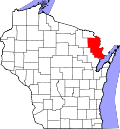
| County | Marinette |
| Elevation | 199 m (653 ft) |
| Time zone | UTC-6 (Central (CST)) |
| • Summer (DST) | UTC-5 (CDT) |
| Area codes | 715 & 534 |
| GNIS feature ID | 1569142 [1] |
May Corner is an unincorporated community located in the town of Grover, Marinette County, Wisconsin, United States.