Pembine (CDP), Wisconsin

Last updated
Pembine, Wisconsin
PembineWisconsinDowntown1US141US8.jpg
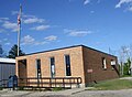
Looking north at downtown Pembine
WIMap-doton-Pembine.png
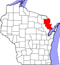
Location in Wisconsin
Coordinates: 45°38′07″N87°59′27″W / 45.63528°N 87.99083°W / 45.63528; -87.99083 Coordinates: 45°38′07″N87°59′27″W / 45.63528°N 87.99083°W / 45.63528; -87.99083
Country United States
State Wisconsin
County Marinette
Area
  Total0.599 sq mi (1.55 km2)
  Land0.598 sq mi (1.55 km2)
  Water0.001 sq mi (0.003 km2)
Elevation
971 ft (296 m)
Population
 (2010) [1]
  Total193
  Density320/sq mi (120/km2)
Time zone UTC-6 (Central (CST))
  Summer (DST) UTC-5 (CDT)
Area code(s) 715 & 534
GNIS feature ID1571162 [2]

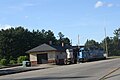
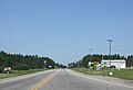
Pembine is an unincorporated census-designated place in Marinette County, Wisconsin (USA), in the town of Pembine. It is located on U.S. Route 141 and U.S. Route 8. It uses the Postal ZIP code 54156. [3] As of the 2010 census, its population is 193. [1]

Images

Related Research Articles

Calumet County, Wisconsin U.S. county in Wisconsin

Calumet County is a county located in the U.S. state of Wisconsin. As of the 2010 census, the population was 48,971. The county seat is Chilton. The county was created in 1836 and organized in 1850.

Beecher, Wisconsin Town in Wisconsin, United States

Beecher is a town in Marinette County, Wisconsin, United States. The population was 783 at the 2000 census. The unincorporated communities of Beecher, Beecher Lake, and White Pine Haven are located in the town.

Pembine, Wisconsin Town in Wisconsin, United States

Pembine is a town in Marinette County, Wisconsin, United States. The population was 1,036 at the 2000 census. The unincorporated community of Kremlin is located in the town, The census-designated place of Pembine is also located in the town.

Manitowoc, Wisconsin City in Wisconsin, United States

Manitowoc is a city in and the county seat of Manitowoc County, Wisconsin, United States. The city is located on Lake Michigan at the mouth of the Manitowoc River. According to the 2020 census, Manitowoc had a population of 34,626, with over 50,000 residents in the surrounding communities.

U.S. Highway 8 (US 8) is a United States Numbered Highway that runs primarily east–west for 280 miles (451 km), mostly within the state of Wisconsin. It connects Interstate 35 (I-35) in Forest Lake, Minnesota, to US 2 at Norway in the Upper Peninsula of Michigan near the border with Wisconsin. Except for the short freeway segment near Forest Lake, and sections near the St. Croix River bridge and Rhinelander, Wisconsin, it is mostly undivided surface road. As a state highway in the three states, US 8 is maintained by the Minnesota, Wisconsin and Michigan departments of transportation.

Collins, Wisconsin Census-designated place in Wisconsin, United States

Collins is an unincorporated census-designated place in the town of Rockland, Manitowoc County, Wisconsin, United States, in the east central part of the state. Its zip code is 54207, although its post office is being studied for closure. As of the 2010 census, its population is 164. The Collins Marsh Wildlife Area is located east of the community. Wisconsin Highway 32 ran through the community; the route later became Wisconsin Highway 67 before it became County Highway W. County Highway JJ and the Wisconsin Central Ltd. railroad runs east–west through the community. Collins has an area of 0.496 square miles (1.28 km2), all of it land. The community was named for Sumner J. Collins, who was the general superintendent of the Wisconsin Central Railroad in the 1890s.

Gotham, Wisconsin Census-designated place in Wisconsin, United States

Gotham is a census-designated place, in the town of Buena Vista, in Richland County, Wisconsin, United States. It is located at the intersection of Wisconsin Highway 60 and U.S. Route 14. It is just north of the Wisconsin River, northeast of Avoca and southeast of Richland Center. As of the 2010 census, its population was 191.

Escanaba and Lake Superior Railroad The Escanaba & Lake Superior is a railroad serving Wisconsin & Michigan.

The Escanaba & Lake Superior Railroad is a Class III shortline railroad that operates 347 miles (558 km) of track in Northeastern Wisconsin and the Upper Peninsula of Michigan. Its main line runs 208 miles (335 km) from Rockland, Michigan, to Green Bay, Wisconsin, and it also owns various branch lines and out-of-service track.

Taycheedah (CDP), Wisconsin Census-designated place in Wisconsin, United States

Taycheedah, Wisconsin is an unincorporated census-designated place in the Town of Taycheedah in Fond du Lac County, Wisconsin. The community is located adjacent to the city of Fond du Lac and Lake Winnebago. As of the 2010 census, its population is 704. Taycheedah calls itself the "Sheepshead Fishing Center of the World". U.S. Route 151 ran through the community until a bypass around Fond du Lac was built in the 2000s.

The Marinette Micropolitan Statistical Area, as defined by the United States Census Bureau, is an area consisting of two counties – one in Wisconsin and one in Michigan – anchored by the city of Marinette, Wisconsin. As of the 2000 census, the μSA had a population of 68,710.

Pembine High School is a high school in the Town of Pembine, Wisconsin. The school is officially named Beecher-Dunbar-Pembine High School after the district to which it belongs. Opened in 1903, the high school originally served the Pembine District, but later added other geographic areas. The school serves K-12 students, with a student population of 257.

Burnett (CDP), Wisconsin Census-designated place in Wisconsin, United States

Burnett is an unincorporated census-designated place located in the town of Burnett, Dodge County, Wisconsin, United States. Burnett is located on Wisconsin Highway 26 5.5 miles (8.9 km) northwest of Horicon. Burnett has a post office with ZIP code 53922. As of the 2010 census, its population is 256.

Winchester (CDP), Wisconsin Census-designated place in Wisconsin, United States

Winchester is an unincorporated census-designated place in the town of Winchester in Winnebago County, Wisconsin, United States. The community is located less than 1 mile from the southern intersection of U.S. Route 10 and U.S. Route 45. Wisconsin Highway 150 passed east–west through the community until the road was decommissioned by the state of Wisconsin, the road is now designated County Highway II. It has an elevation of 846 feet above mean sea level at latitude 44.199 and longitude -88.665. As of the 2010 census, its population is 671.

Elcho (CDP), Wisconsin Census-designated place in Wisconsin, United States

Elcho is an unincorporated community and census-designated place (CDP) in the town of Elcho, Langlade County, Wisconsin, United States. Elcho is located on U.S. Route 45 and Wisconsin Highway 47 16.5 miles (26.6 km) southwest of Crandon. Elcho has a post office with ZIP code 54428. As of the 2010 census, its population was 339.

Three Lakes (CDP), Wisconsin Census-designated place in Wisconsin, United States

Three Lakes is an unincorporated census-designated place located in the town of Three Lakes, Oneida County, Wisconsin, United States. Three Lakes is located at the junction of U.S. Route 45 and Wisconsin Highway 32 9 miles (14 km) south-southeast of Eagle River. Three Lakes has a post office with ZIP code 54562. As of the 2010 census, its population is 605.

Woodruff (CDP), Wisconsin Census-designated place in Wisconsin, United States

Woodruff is a census-designated place in the Town of Woodruff in Oneida County, Wisconsin, United States.

Abrams (CDP), Wisconsin Census-designated place in Wisconsin, United States

Abrams is an unincorporated community census-designated place located in the town of Abrams, Oconto County, Wisconsin, United States. Abrams is located near U.S. Route 41 and U.S. Route 141 8 miles (13 km) south-southeast of Oconto Falls. Abrams has a post office with ZIP code 54101. As of the 2010 census, its population was 340.

Kremlin, Wisconsin Unincorporated community in Wisconsin, United States

Kremlin is an unincorporated community located in the town of Pembine, Marinette County, Wisconsin, United States.

Menominee River State Park and Recreation Area

Menominee River State Park and Recreation Area is a state park unit of Wisconsin, United States, in development along the Menominee River. It was created in 2010 in conjunction with the Menominee River State Recreation Area on the Michigan side of the border river. The Wisconsin park is located in the towns of Niagara, Pembine, and Beecher in Marinette County in northeast Wisconsin. The 6,563-acre (2,656 ha) park comprises an undeveloped northern unit and a southern portion with primitive hiking trails and canoe/walk-in campsites.

Lindquist Lake


Lindquist Lake is a freshwater lake in northeastern Wisconsin.

References

  1. 1 2 "U.S. Census website". U.S. Census Bureau . Retrieved 17 April 2011.
  2. U.S. Geological Survey Geographic Names Information System: Pembine (CDP), Wisconsin
  3. "Pembine, WI Profile: Facts & Data".