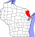
Goodman, Wisconsin

Last updated

Goodman, Wisconsin
WIMap-doton-Goodman.png
Location of Goodman, Wisconsin
Coordinates: 45°38′0″N88°19′30″W / 45.63333°N 88.32500°W / 45.63333; -88.32500
Country Flag of the United States.svg  United States
State Flag of Wisconsin.svg  Wisconsin
County Marinette
Area
  Total107.6 sq mi (278.6 km2)
  Land105.9 sq mi (274.2 km2)
  Water1.7 sq mi (4.4 km2)
Elevation
[1]
1,375 ft (419 m)
Population
 (2000)
  Total820
  Density7.7/sq mi (3.0/km2)
Time zone UTC-6 (Central (CST))
  Summer (DST) UTC-5 (CDT)
FIPS code 55-29775 [2]
GNIS feature ID1583289 [1]

Goodman is a town in Marinette County, Wisconsin, United States. The population was 820 at the 2000 census. The census-designated place of Goodman is located in the town.

Contents

Geography

According to the United States Census Bureau, the town has a total area of 107.6 square miles (278.6 km2), of which, 105.9 square miles (274.2 km2) of it is land and 1.7 square miles (4.4 km2) of it (1.59%) is water.

Demographics

As of the census [2] of 2000, there were 820 people, 360 households, and 240 families residing in the town. The population density was 7.7 inhabitants per square mile (3.0/km2). There were 680 housing units at an average density of 6.4 per square mile (2.5/km2). The racial makeup of the town was 98.29% White, 0.24% African American, 0.49% Native American, 0.12% Asian, 0.12% from other races, and 0.73% from two or more races. Hispanic or Latino of any race were 0.98% of the population.

There were 360 households, out of which 21.7% had children under the age of 18 living with them, 60.6% were married couples living together, 3.3% had a female householder with no husband present, and 33.3% were non-families. 28.1% of all households were made up of individuals, and 14.7% had someone living alone who was 65 years of age or older. The average household size was 2.28 and the average family size was 2.75.

In the town, the population was spread out, with 18.7% under the age of 18, 6.7% from 18 to 24, 23.8% from 25 to 44, 27.7% from 45 to 64, and 23.2% who were 65 years of age or older. The median age was 45 years. For every 100 females, there were 109.7 males. For every 100 females age 18 and over, there were 103.4 males.

The median income for a household in the town was $31,087, and the median income for a family was $34,250. Males had a median income of $30,938 versus $20,750 for females. The per capita income for the town was $15,941. About 6.6% of families and 9.4% of the population were below the poverty line, including 12.3% of those under age 18 and 9.3% of those age 65 or over.

History

The origins of Goodman date to the late 1800s, when it was created as a logging community for the Sawyer-Goodman Lumber Company by the Goodman brothers: James B. Goodman (1841–1907), Robert F. Goodman (1844–1924), and William O. Goodman (1848–1936). The settlement was initially named Dunbar in 1899, and the name was changed to Goodman in 1915. [3]

Robert F. Goodman's son Robert B. Goodman (1871–1957) is thought to be one of the first loggers in the country to utilize selective cutting practices. During a 62-year period, starting in 1927, the Goodman Lumber Company removed 417 million board feet of timber. Today, due to the use of selective cutting the volume of timber available is of similar volume as there was in 1927. The town center contains the Goodman Club House, which had a ballroom, theater, and restaurant. This Club House was once known to draw well-known performers, [4] and it's recently reopened under new ownership.

100th anniversary

Goodman celebrated its 100th anniversary on August 8–9, 2008. It is estimate that over 4,000 people attended. Events included a play commemorating the founding of Goodman as company town, a lumberjack breakfast, a lumberjack exhibition, saw playing, a parade, and a fireworks display.

Related Research Articles

<span class="mw-page-title-main">Marinette County, Wisconsin</span> County in Wisconsin, United States

Marinette County is a county in the U.S. state of Wisconsin. As of the 2020 census, the population was 41,872. Its county seat is Marinette. Marinette County is part of the Marinette, WI–MI Micropolitan Statistical Area.

<span class="mw-page-title-main">Millry, Alabama</span> Town in Alabama, United States

Millry is a town in Washington County, Alabama, United States. According to the 1950 U.S. Census records, it incorporated in 1947. The population was 546 at the 2010 census, down from 615 in 2000.

<span class="mw-page-title-main">Hendricks, West Virginia</span> Town in West Virginia, United States

Hendricks is a town in Tucker County, West Virginia, United States. The population was 226 at the 2020 census. The Blackwater River and the Dry Fork join at Hendricks to form the Black Fork, a principal tributary of the Cheat River.

Stanley is a town in Barron County in the U.S. state of Wisconsin. The population was 2,546 at the 2010 census. The town surrounds the village of Cameron but is separate from it.

<span class="mw-page-title-main">Laona, Wisconsin</span> Town in Wisconsin, United States

Laona is a town in Forest County, Wisconsin, United States. The population was 1,212 at the 2010 census. The census-designated place of Laona is located in the town. The unincorporated community of Blackwell Junction is also located partially in the town.

<span class="mw-page-title-main">Eau Pleine, Marathon County, Wisconsin</span> Town in Wisconsin, United States

Eau Pleine is a town in Marathon County, Wisconsin, United States. It is part of the Wausau, WI Metropolitan Statistical Area. The population was 773 at the 2010 census. The unincorporated communities of Little Rose, and Weber are located in the town. The ghost towns of Staadts and March Rapids were also located in the town.

<span class="mw-page-title-main">Amberg, Wisconsin</span> Town in Wisconsin, United States

Amberg is a town in Marinette County, Wisconsin, United States. The population was 693 at the 2020 census. The unincorporated community of Cedarville is located partially in the town. The census-designated place of Amberg is located within the town.

<span class="mw-page-title-main">Athelstane, Wisconsin</span> Town in Wisconsin, United States

Athelstane is a town in Marinette County, Wisconsin, United States. The population was 601 at the 2000 census. The unincorporated community of Athelstane is located in the town.

<span class="mw-page-title-main">Beaver, Marinette County, Wisconsin</span> Town in Wisconsin, United States

Beaver is a town in Marinette County, Wisconsin, United States. The population was 1,123 at the 2000 census. The unincorporated community of Beaver is located in the town.

<span class="mw-page-title-main">Coleman, Wisconsin</span> Village in Wisconsin, United States

Coleman is a village in Marinette County, Wisconsin, United States. The population was 726 at the 2020 census. It is part of the Marinette, WI–MI Micropolitan Statistical Area.

<span class="mw-page-title-main">Crivitz, Wisconsin</span> Village in Wisconsin, United States

Crivitz is a village in Marinette County, Wisconsin, United States. The population was 1,093 at the 2020 census. It is part of the Marinette, WI–MI Micropolitan Statistical Area.

<span class="mw-page-title-main">Dunbar, Wisconsin</span> Town in Wisconsin, United States

Dunbar is a town in Marinette County, Wisconsin, United States. The population was 1,303 at the 2000 census. The census-designated place of Dunbar is located in the town.

<span class="mw-page-title-main">Lake, Marinette County, Wisconsin</span> Town in Wisconsin, United States

Lake is a town in Marinette County, Wisconsin, United States. As of the 2000 census, the town population was 1,064. The unincorporated community of Loomis is located in the town,

<span class="mw-page-title-main">Middle Inlet, Wisconsin</span> Town in Wisconsin, United States

Middle Inlet is a town in Marinette County, Wisconsin, United States. The population was 831 at the 2000 census.

<span class="mw-page-title-main">Porterfield, Wisconsin</span> Town in Wisconsin, United States

Porterfield is a town in Marinette County, Wisconsin, United States. The population was 1,991 at the 2000 census. The unincorporated communities of Bagley Junction, Miles, Porterfield, Rubys Corner, and Walsh are located in the town.

<span class="mw-page-title-main">Niagara, Wisconsin</span> City in Wisconsin, United States

Niagara is a city in Marinette County, Wisconsin, United States. The population was 1,602 at the 2020 census. The city lies to the north of and adjacent to the Town of Niagara. It is part of the Marinette, WI–MI Micropolitan Statistical Area.

<span class="mw-page-title-main">Pound, Wisconsin</span> Village in Wisconsin, United States

Pound is a village in Marinette County, Wisconsin, United States. The population was 377 at the 2010 census. The village is located within the Town of Pound. Pound is part of the Marinette, WI– MI Micropolitan Statistical Area.

<span class="mw-page-title-main">Pound (town), Wisconsin</span>

Pound is a town in Marinette County, Wisconsin, United States. The population was 1,367 at the 2000 census. The village of Pound is located within but politically independent of the town.

<span class="mw-page-title-main">Wausaukee, Wisconsin</span> Village in Wisconsin, United States

Wausaukee is a village in Marinette County, Wisconsin, in the United States. The population was 596 at the 2020 census. The village is part of the Marinette, WI–MI Micropolitan Statistical Area.

Wausaukee is a town in Marinette County, Wisconsin, United States. The estimated population was 573 in 2011. The Village of Wausaukee is located within the town. The unincorporated community of Cedarville is located partially in the town.

References

  1. 1 2 "US Board on Geographic Names". United States Geological Survey. October 25, 2007. Retrieved January 31, 2008.
  2. 1 2 "U.S. Census website". United States Census Bureau . Retrieved January 31, 2008.
  3. Callary, Edward (2016). Place Names of Wisconsin. Madison, WI: University of Wisconsin Press. p. 106.
  4. "Town of Goodman, Marinette County, Wisconsin | Official Website of the Town of Goodman". townofgoodman.com. Retrieved November 11, 2018.

45°37′53″N88°21′12″W / 45.63139°N 88.35333°W / 45.63139; -88.35333