Middle Inlet, Wisconsin

Last updated

Middle Inlet, Wisconsin
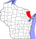
WIMap-doton-Middle Inlet.png
Location of Middle Inlet, Wisconsin
Coordinates: 45°17′3″N87°56′7″W / 45.28417°N 87.93528°W / 45.28417; -87.93528
Country Flag of the United States.svg  United States
State Flag of Wisconsin.svg  Wisconsin
County Marinette
Area
  Total51.5 sq mi (133.4 km2)
  Land50.7 sq mi (131.4 km2)
  Water0.8 sq mi (2.0 km2)
Elevation
[1]
686 ft (209 m)
Population
 (2000)
  Total831
  Density16.4/sq mi (6.3/km2)
Time zone UTC-6 (Central (CST))
  Summer (DST) UTC-5 (CDT)
FIPS code 55-51537 [2]
GNIS feature ID1583710 [1]

Middle Inlet is a town in Marinette County, Wisconsin, United States. The population was 831 at the 2000 census.

Contents

Communities

Geography

According to the United States Census Bureau, the town has a total area of 51.5 square miles (133.4 km2), of which, 50.7 square miles (131.4 km2) of it is land and 0.8 square miles (2.0 km2) of it (1.50%) is water.

Demographics

As of the census [2] of 2000, there were 831 people, 366 households, and 245 families residing in the town. The population density was 16.4 people per square mile (6.3/km2). There were 643 housing units at an average density of 12.7 per square mile (4.9/km2). The racial makeup of the town was 98.32% White, 0.24% African American, 0.72% Native American, 0.24% Asian, and 0.48% from two or more races. Hispanic or Latino of any race were 0.12% of the population.

There were 366 households, out of which 21.9% had children under the age of 18 living with them, 59.8% were married couples living together, 4.9% had a female householder with no husband present, and 32.8% were non-families. 27.6% of all households were made up of individuals, and 12.6% had someone living alone who was 65 years of age or older. The average household size was 2.27 and the average family size was 2.77.

In the town, the population was spread out, with 19.0% under the age of 18, 5.4% from 18 to 24, 22.3% from 25 to 44, 32.1% from 45 to 64, and 21.2% who were 65 years of age or older. The median age was 46 years. For every 100 females, there were 103.2 males. For every 100 females age 18 and over, there were 105.2 males.

The median income for a household in the town was $32,054, and the median income for a family was $36,750. Males had a median income of $29,808 versus $17,969 for females. The per capita income for the town was $16,082. About 6.1% of families and 9.4% of the population were below the poverty line, including 14.7% of those under age 18 and 8.4% of those age 65 or over.

Related Research Articles

<span class="mw-page-title-main">Kinsey, Alabama</span> Town in Alabama, United States

Kinsey is a town in Houston County, Alabama, United States. It was initially located and incorporated in Henry County in February 1893. In 1903, it was redrawn into newly created Houston County and was later reincorporated in August 1957. It is part of the Dothan, Alabama Metropolitan Statistical Area. At the 2010 census the population was 2,198, up from 1,796 in 2000.

<span class="mw-page-title-main">Bunker Hill, Indiana</span> Town in Indiana, United States

Bunker Hill is a town in Pipe Creek Township, Miami County, in the U.S. state of Indiana. The population was 814 at the 2020 census, down from 888 in 2010.

<span class="mw-page-title-main">Sherman, Maine</span> Town in the state of Maine, United States

Sherman is a town in Aroostook County, Maine, United States. The population was 815 at the 2020 census.

<span class="mw-page-title-main">West Gardiner, Maine</span> Town in the state of Maine, United States

West Gardiner is a town in Kennebec County, Maine, United States. The population was 3,671 at the 2020 census. West Gardiner is included in the Augusta, Maine micropolitan New England City and Town Area.

Plymouth is a town in Penobscot County, Maine, United States. The population was 1,325 at the 2020 census.

<span class="mw-page-title-main">Lyman, Maine</span> Town in the state of Maine, United States

Lyman is a town in York County, Maine, United States. The population was 4,525 at the 2020 census. It is part of the Portland–South Portland–Biddeford, Maine metropolitan statistical area. Lyman, together with Alfred, is home to Massabesic Experimental Forest.

<span class="mw-page-title-main">Noxapater, Mississippi</span> Town in Mississippi, United States

Noxapater is a town in Winston County, Mississippi. The population was 472 at the 2010 census.

<span class="mw-page-title-main">La Puebla, New Mexico</span> CDP in New Mexico, United States

La Puebla is a census-designated place (CDP) in Santa Fe County, New Mexico, United States. It is part of the Santa Fe, New Mexico Metropolitan Statistical Area. The population was 1,296 at the 2000 census.

<span class="mw-page-title-main">South Heart, North Dakota</span> City in North Dakota, United States

South Heart is a city in Stark County, North Dakota, United States. The population was 394 at the 2020 census. It is part of the Dickinson Micropolitan Statistical Area. South Heart was founded in 1908.

<span class="mw-page-title-main">East Keating Township, Clinton County, Pennsylvania</span> Township in Pennsylvania, United States

East Keating Township is a township in Clinton County, Pennsylvania. The population was 9 at the 2020 census, the second smallest municipality in terms of population in Pennsylvania behind Centralia.

<span class="mw-page-title-main">Wind Gap, Pennsylvania</span> Borough in Pennsylvania, United States

Wind Gap is a borough in Northampton County, Pennsylvania. The population of Wind Gap was 2,820 at the 2020 census. Wind Gap is part of the Lehigh Valley metropolitan area, which had a population of 861,899 and was the 68th-most populous metropolitan area in the U.S. as of the 2020 census.

<span class="mw-page-title-main">Elmer City, Washington</span> Town in Washington, United States

Elmer City is a town in Okanogan County, Washington, United States. The population was 238 at the 2010 census.

<span class="mw-page-title-main">Sherman, Clark County, Wisconsin</span> Town in Wisconsin, United States

Sherman is a town in Clark County, Wisconsin, United States. The population was 831 at the 2000 census. The unincorporated community of Veefkind is located in the town. The unincorporated community of Spokeville is also located partially in the town.

<span class="mw-page-title-main">Wagner, Wisconsin</span> Town in Wisconsin, United States

Wagner is a town in Marinette County, Wisconsin, United States. The population was 722 at the 2000 census. The unincorporated communities of Goll, McAllister, Packard, and Wagner are located in the town.

<span class="mw-page-title-main">Grand Chute, Wisconsin</span> Town in Wisconsin, United States

Grand Chute is a town in Outagamie County, Wisconsin, United States. The population was 23,831 at the 2020 census. The unincorporated community of Apple Creek is partially located in the town. It was the birthplace of U.S. Senator Joseph McCarthy.

<span class="mw-page-title-main">Town of Maine, Wisconsin</span> Town in Wisconsin, United States

Maine is a town in Outagamie County, Wisconsin, United States. The population was 831 at the 2000 census. The unincorporated community of Leeman is located in the town.

<span class="mw-page-title-main">Chilton (town), Wisconsin</span>

Chilton is a town in Calumet County in the U.S. state of Wisconsin. The population was 1,143 at the 2010 census. The City of Chilton is located partially within the town. The unincorporated community of Brant is located in the town.

The Town of Potosi is located in Grant County, Wisconsin, United States. The population was 831 at the 2000 census. The Village of Potosi and the unincorporated communities of British Hollow, Buena Vista, Rockville, and Van Buren are located in the town.

<span class="mw-page-title-main">Ridgeway, Wisconsin</span> Village in Wisconsin, United States

Ridgeway is a village in Iowa County, Wisconsin, United States. The population was 624 at the 2020 census. The village is adjacent to the Town of Ridgeway. It is part of the Madison Metropolitan Statistical Area.

Wausaukee is a town in Marinette County, Wisconsin, United States. The estimated population was 573 in 2011. The Village of Wausaukee is located within the town. The unincorporated community of Cedarville is located partially in the town.

References

  1. 1 2 "US Board on Geographic Names". United States Geological Survey. October 25, 2007. Retrieved January 31, 2008.
  2. 1 2 "U.S. Census website". United States Census Bureau . Retrieved January 31, 2008.

45°17′30″N87°59′32″W / 45.29167°N 87.99222°W / 45.29167; -87.99222