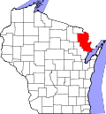
Cedarville, Wisconsin

Last updated
Cedarville, Wisconsin
USA Wisconsin location map.svg
Red pog.svg
Cedarville, Wisconsin
Usa edcp location map.svg
Red pog.svg
Cedarville, Wisconsin
Coordinates: 45°27′13″N87°58′58″W / 45.45361°N 87.98278°W / 45.45361; -87.98278 Coordinates: 45°27′13″N87°58′58″W / 45.45361°N 87.98278°W / 45.45361; -87.98278
Country Flag of the United States.svg  United States
State Flag of Wisconsin.svg  Wisconsin
County Marinette
Elevation
255 m (837 ft)
Time zone UTC-6 (Central (CST))
  Summer (DST) UTC-5 (CDT)
Area code(s) 715 & 534
GNIS feature ID1562873 [1]

Cedarville is an unincorporated community located in the towns of Amberg and Wausaukee, Marinette County, Wisconsin, United States.

Contents

Geography

Cedarville, 1912 map detail Cedarville Wisconsin 1912.jpg
Cedarville, 1912 map detail

Cedarville is 6 miles (9.7 km) north-northwest of the village of Wausaukee, at the intersection of Amberg–Wausaukee Road and Old 38 Road [2] at an elevation of 837 feet (255 m). [1] It is located along the Escanaba and Lake Superior Railroad. Cedarville is connected by road to Athelstane (via County Highways V and C) to the west, Amberg to the north, and Wausaukee to the south. Little Wausaukee Creek and Cedar Lake lie the southwest, and Cedarville Creek flows to the east. [2]

Name

The name Cedarville refers to the white cedar that grew and was cut in the area. The railroad station at Cedarville was used for storage and transport of cedar in the early 20th century. [3] [4]

History

The railroad connection to Cedarville was built by the Bird and Wells Lumber Company in the 1890s. [5] In 1906, forest fires caused significant damage in Cedarville. Railroad cars loaded with wood burned on the tracks, and cedar-filled drying kilns burned. Together with neighboring Wausaukee, losses were estimated at $200,000. [3] By 1916, Cedarville had 54 households; the settlers were mostly farmers from Indiana, Illinois, and Iowa. [6] That same year, the community was platted as a town with two named streets, and it had a train station, potato warehouse, school, church, store, garage, and post office. [7] An agricultural fair was held in Cedarville in the 1920s, [8] and the settlement received electricity in 1925. [9] However, by 1925 the settlement had also started to decline, with many families moving away. [10]

Related Research Articles

<span class="mw-page-title-main">Marinette County, Wisconsin</span> County in Wisconsin, United States

Marinette County is a county in the U.S. state of Wisconsin. As of the 2020 census, the population was 41,872. Its county seat is Marinette. Marinette County is part of the Marinette, WI–MI Micropolitan Statistical Area.

<span class="mw-page-title-main">Marinette, Wisconsin</span> City in Wisconsin, United States

Marinette is a city in and the county seat of Marinette County, Wisconsin, United States. It is located on the south bank of the Menominee River, at its mouth at Green Bay, part of Lake Michigan; to the north is Stephenson Island, part of the city preserved as park. During the lumbering boom of the late 19th century, Marinette became the tenth-largest city in Wisconsin in 1900, reaching a peak population of 16,195.

<span class="mw-page-title-main">Wisconsin Highway 180</span>

State Trunk Highway 180 is a 30.42-mile (48.96 km), north–south state highway in southeastern Marinette County, Wisconsin, United States, that runs from Wisconsin Highway 64 (WIS 64) in Marinette to U.S. Route 141 (US 141) in Wausaukee.

<span class="mw-page-title-main">Amberg (CDP), Wisconsin</span> Census-designated place in Wisconsin, United States

Amberg is an unincorporated census-designated place in Marinette County, Wisconsin, United States, in the town of Amberg. It is located on U.S. Highway 141. As of the 2010 census, its population was 180. The Amberg Historical Society operates the Amberg Historical Museum Complex which consists of the historic town hall that is on the National Register of Historic Places, the community's train depot, a 1900-era house, and the Amberg Museum.

<span class="mw-page-title-main">Marinette micropolitan area</span>

The Marinette Micropolitan Statistical Area, as defined by the United States Census Bureau, is an area consisting of two counties – one in Wisconsin and one in Michigan – anchored by the city of Marinette, Wisconsin. As of the 2000 census, the μSA had a population of 68,710.

<span class="mw-page-title-main">Middle Inlet (community), Wisconsin</span> Unincorporated community in Wisconsin, United States

Middle Inlet is an unincorporated community in Marinette County, Wisconsin (USA), in the town of Middle Inlet.

<span class="mw-page-title-main">Hiram Orlando Fairchild</span> 19th century American lawyer & politician

Hiram Orlando Fairchild was an American lawyer and Republican politician. He was the 34th speaker of the Wisconsin State Assembly and served as the first district attorney of Marinette County, Wisconsin. His name was often abbreviated as H. O. Fairchild.

<span class="mw-page-title-main">Porterfield (community), Wisconsin</span> Unincorporated community and Census-designated place in Wisconsin, United States

Porterfield is a census-designated place in the town of Porterfield, Marinette County, Wisconsin, United States.

<span class="mw-page-title-main">Rubys Corner, Wisconsin</span> Unincorporated community in Wisconsin, United States

Rubys Corner is an unincorporated community located in the town of Porterfield, Marinette County, Wisconsin, United States.

Loomis is an unincorporated community located in the town of Lake, Marinette County, Wisconsin, United States.

McAllister is an unincorporated community located in the town of Wagner, Marinette County, Wisconsin, United States.

<span class="mw-page-title-main">May Corner, Wisconsin</span> Unincorporated community in Wisconsin, United States

May Corner is an unincorporated community located in the town of Grover, Marinette County, Wisconsin, United States.

Harmony is an unincorporated community located in the town of Grover, Marinette County, Wisconsin, United States. Harmony is located 5 miles (8.0 km) northwest of Peshtigo.

<span class="mw-page-title-main">Bagley Junction, Wisconsin</span> Unincorporated community in Wisconsin, United States

Bagley Junction is an unincorporated community located in the town of Porterfield, Marinette County, Wisconsin, United States.

<span class="mw-page-title-main">Miles, Wisconsin</span> Unincorporated community in Wisconsin, United States

Miles is an unincorporated community located in the town of Porterfield, Marinette County, Wisconsin, United States.

<span class="mw-page-title-main">Wagner (community), Wisconsin</span> Unincorporated community in Wisconsin, United States

Wagner is an unincorporated community located in the town of Wagner, Marinette County, Wisconsin, United States. Wagner is 11.5 miles (18.5 km) east-southeast of Wausaukee.

Kremlin is an unincorporated community located in the town of Pembine, Marinette County, Wisconsin, United States.

<span class="mw-page-title-main">Harlan P. Bird</span> American politician (1838–1912)

Harlan Page Bird was an American businessman and Republican politician. He served 8 years in the Wisconsin State Senate, representing northeast Wisconsin.

Koss is an unincorporated community in Menominee County, Michigan, United States. Koss is located in Lake Township, 4.9 miles (7.9 km) west-southwest of Stephenson.

<span class="mw-page-title-main">The Brothers Three</span>

The Brothers Three is a pizza restaurant in Marinette, Wisconsin and former pizza chain. It was founded in Cicero, Illinois in 1968 by the brothers Glen, Keith, and Dale Nergaard. In 1972 they opened the Marinette location. Over the next several decades, they expanded the chain to other locations across Wisconsin. Currently only one location remains, in Marinette. There is another The Brothers Three in Oconto, Wisconsin, which was formerly part of the chain, but is now independently run.

References

  1. 1 2 U.S. Geological Survey Geographic Names Information System: Cedarville, Wisconsin
  2. 1 2 Wausaukeee Quadrangle Wisconsin–Marinette Co., 15 Minute Series (Topographic). 1963. Map, 1:62,500. Washington, DC: U. S. Geological Survey.
  3. 1 2 "The Forests Are Swept by Flames". The Green Bay Press-Gazette. May 19, 1906. p. 1. Retrieved December 25, 2019 via Newspapers.com. Open Access logo PLoS transparent.svg
  4. "Timber for Cheese Boxes Being Cut". The Green Bay Press-Gazette. December 12, 1912. p. 12. Retrieved December 25, 2019 via Newspapers.com. Open Access logo PLoS transparent.svg
  5. "The Bird and Wells Lumber Company". The Green Bay Press-Gazette. May 29, 1894. p. 3. Retrieved December 25, 2019 via Newspapers.com. Open Access logo PLoS transparent.svg
  6. "Cedarville Forms Anti-Tobacco Club". The Green Bay Press-Gazette. August 26, 1916. p. 8. Retrieved December 26, 2019 via Newspapers.com. Open Access logo PLoS transparent.svg
  7. "Cedarville Switch 1917 Now Prosperous Town". The Green Bay Press-Gazette. September 28, 1916. p. 4. Retrieved December 26, 2019 via Newspapers.com. Open Access logo PLoS transparent.svg
  8. "Four Community Fairs Scheduled". The Green Bay Press-Gazette. October 17, 1924. p. 16. Retrieved December 29, 2019 via Newspapers.com. Open Access logo PLoS transparent.svg
  9. "W. P. S. Buys Light Plant at Pembine". The Green Bay Press-Gazette. March 21, 1925. p. 11. Retrieved December 29, 2019 via Newspapers.com. Open Access logo PLoS transparent.svg
  10. "Consider Closing of School at Cedarville". The Green Bay Press-Gazette. November 20, 1925. p. 11. Retrieved December 31, 2019 via Newspapers.com. Open Access logo PLoS transparent.svg