The geography of Bolivia includes the Eastern Andes Mountain Range which bisects Bolivia roughly from north to south. To the east of that mountain chain are lowland plains of the Amazon Basin, and to the west is the Altiplano which is a highland plateau where Lake Titicaca is located. Bolivia's geography has features similar to those of Peru which abuts Bolivia's northwest border; like Bolivia, Peru is bisected from north to south by the Eastern Andes Mountains, and these two countries share Lake Titicaca which is the highest navigable lake on Earth. Unlike Peru, however, Bolivia is one of the two landlocked countries in South America, the other being Paraguay which is located along Bolivia's southeast border.

A swamp is a forested wetland. Swamps are considered to be transition zones because both land and water play a role in creating this environment. Swamps vary in size and are located all around the world. The water of a swamp may be fresh water, brackish water, or seawater. Freshwater swamps form along large rivers or lakes where they are critically dependent upon rainwater and seasonal flooding to maintain natural water level fluctuations. Saltwater swamps are found along tropical and subtropical coastlines. Some swamps have hammocks, or dry-land protrusions, covered by aquatic vegetation, or vegetation that tolerates periodic inundation or soil saturation. The two main types of swamp are "true" or swamp forests and "transitional" or shrub swamps. In the boreal regions of Canada, the word swamp is colloquially used for what is more formally termed a bog, fen, or muskeg. Some of the world's largest swamps are found along major rivers such as the Amazon, the Mississippi, and the Congo.

The Virgin River is a tributary of the Colorado River in the U.S. states of Utah, Nevada, and Arizona. The river is about 162 miles (261 km) long. It was designated Utah's first wild and scenic river in 2009, during the centennial celebration of Zion National Park.
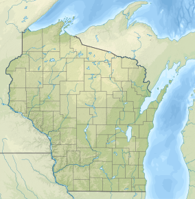
The Driftless Area, a region in the American Midwest, comprises southwestern Wisconsin, southeastern Minnesota, northeastern Iowa, and the extreme northwestern corner of Illinois. It was never covered by ice during the last ice age, and therefore lacks glacial deposits, also termed drift. Its landscape is characterized by steep hills, forested ridges, deeply carved river valleys, and karst geology with spring-fed waterfalls and cold-water trout streams. Ecologically, the Driftless Area's flora and fauna are more closely related to those of the Great Lakes region and New England than those of the broader Midwest and central Plains regions. The steep riverine landscape of both the Driftless Area proper and the surrounding Driftless-like region are the result of early glacial advances that forced preglacial rivers that flowed into the Great Lakes southward, causing them to carve a gorge across bedrock cuestas, thereby forming the modern incised upper Mississippi River valley. The region has elevations ranging from 603 to 1,719 feet at Blue Mound State Park, and together with the Driftless-like region, covers 24,000 square miles (62,200 km2).
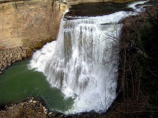
Burgess Falls State Park is a state park and state natural area in Putnam County and White County, Tennessee, located in the southeastern United States. The park is situated around a steep gorge in which the Falling Water River drops 250 feet (76 m) in elevation in less than a mile, culminating in a 136-foot (41 m) cataract waterfall.

Edgar Evins State Park is a state park in DeKalb County, Tennessee, in the southeastern United States. The park consists of 6,300 acres (25 km2) along the shores of Center Hill Lake, an impoundment of the Caney Fork. The State of Tennessee leases the land from the U.S. Army Corps of Engineers.
Rice Lake State Park is a state park of Minnesota, United States, just east of Owatonna. Park lands entirely surround Rice Lake, an important stopping point for migrating waterfowl. The lake covers 750 acres (300 ha) with an average depth of three feet (1 m).
Lake Shetek is the largest lake in southwestern Minnesota, United States, and the headwaters of the Des Moines River. It is located in The Lakes, an unincorporated community in Murray County a few miles north-northwest of Currie. The name Shetek is derived from "pelican" in the Ojibwe language.
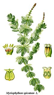
Myriophyllum spicatum is native to Europe, Asia, and north Africa, but has a wide geographic and climatic distribution among some 57 countries, extending from northern Canada to South Africa. It is a submerged aquatic plant, grows in still or slow-moving water, and is considered to be a highly invasive species.
Green Lake — also known as Big Green Lake — is a lake in Green Lake County, Wisconsin, United States. Green Lake has a maximum depth of 237 ft (72 m), making it the deepest natural inland lake in Wisconsin and the second largest by volume. The lake covers 29.72 km2 and has an average depth of 30.48 m (100.0 ft). Green Lake has 43.94 km (27.30 mi) of diverse shoreline, ranging from sandstone bluffs to marshes.

The geology of Minnesota comprises the rock, minerals, and soils of the U.S. state of Minnesota, including their formation, development, distribution, and condition.

Rocky Fork State Park is a public recreation area located in Highland County, Ohio, United States. The state park's central feature is 2,080-acre (840 ha) Rocky Fork Lake and its 31 miles (50 km) of shoreline. The lake was added to the state park system in 1950. The park offers marinas, boat ramps, swimming beaches, picnic areas, hiking trails and nature center. Two significant archaeological sites dating from the Hopewellian period are located in the park, the Rocky Fork Park Group and the Rocky Fork Park Site.

Whitefish Dunes State Park is a 867-acre (351 ha) state park of Wisconsin, United States, on the eastern shore of the Door Peninsula. This day-use park preserves the most substantial sand dunes on the western shore of Lake Michigan. The remains of eight successive prehistoric Native American villages are on the National Register of Historic Places as Whitefish Dunes-Bay View Site. Cave Point County Park is an enclave inside the state park, allowing visitors free foot access to the state park by the shoreline trail connecting the parks.

The Starhead topminnow is a native United States species that ranges from the Ouachita River drainage in Louisiana, the Big Black river in Mississippi, and extends northward into the Mississippi River and Lake Michigan basins to the southern Michigan and southern Wisconsin areas. The Starhead topminnow is endangered due to the removal of aquatic vegetation and the continued development of land that infringes on its habitat.
There are three Manistique Lakes in the Upper Peninsula of Michigan. The lakes include North Manistique Lake, Big Manistique Lake, and South Manistique Lake. The towns surrounding the lakes are Curtis Township, Germfask, and Helmer. The lakes are known for vacationing and fishing. They are also in close proximity to other natural sights such as the Great Lakes, rivers, and smaller lakes as well as tourist attractions including the Canada–US border, the Soo Locks, Mackinac Island, parks, and museums.

Grandma Lake Wetlands State Natural Area is a Wisconsin Department of Natural Resources-designated State Natural Area featuring the undeveloped, pristine 44-acre Grandma Lake, which lies in a depression formed during the last glacial period. The lake is ringed by a large, open sphagnum bog mat. The bog mat is surrounded by a coniferous swamp of tamarack and black spruce. The bog mat supports a plant community that is considered diverse and unusual, with several rare species present, including: bog arrow-grass, dragon's mouth orchid, livid sedge, small-headed bog sedge, as well as one of only a few known populations of bog rush in the State of Wisconsin. In 1991, the US Forest Service designated the site as a Research Natural Area. Also, the site is listed as one of Wisconsin's Wetland Gems, by the Wisconsin Wetlands Association.

Rice Creek is a Wisconsin Department of Natural Resources-designated State Natural Area that features a large, high-quality wetland complex of conifer swamps, fens, and sedge meadows along a two-mile stretch of Rice Creek. The creek contains dense, lush beds of emergent and submergent aquatic vegetation, including wild rice. White cedar, balsam fir, black spruce, and tamarack are the dominant trees in the conifer swamp. Several stands of old-growth hemlock/hardwood forest can be found in the site, each with a supercanopy of large white pine. Two fens, fed by groundwater seepages and of exceptional floristic diversity, are found near the creek. Overall, the site supports a high concentration of rare plants and animals. At least seven species of orchid are found here: showy lady slipper, heart-leaf twayblade, swamp pink, striped coralroot, blunt-leaf orchid, northern bog orchid, and boreal bog orchid. Other notable plant species include: bog arrowgrass, naked miterwort, marsh cinquefoil, purple clematis, and downy willowherb. Notable animal species present include: barred owl, Canada jay, pine siskin, winter wren, and bog copper.

Stingray Swamp Flora Reserve (SWFR) is located immediately north of Penrose township in the south-western region of Wingecarribee Shire. The reserve is primarily surrounded by the Penrose State Forest, which is a commercially active plantation forest administered by the Forest Corporation NSW. Pine species dominate the state forest with a mix of native vegetation types in isolated pockets and adjacent areas. Stingray Swamp Flora Reserve belongs to a larger wetland complex known as the Paddy’s River Wetland Complex (PRWC). These wetlands also form part of the Paddy’s River sub-catchment, which belong to the larger Hawkesbury-Nepean catchment. Historic use of this area has mainly been that of pine plantation, agriculture and mining activities. The forest is publicly accessible and therefore is a site of mixed recreational activities.
Pine lake is a deep seepage lake near the community of Springwater, Wisconsin, in Waushara County, located in central Wisconsin. It is one of eight lakes that can be found in the township of Springwater. This lake is 137 acres with a 48-foot maximum depth. It is a popular attraction for both fisherman and boaters.

Little Rock Lake is a lake in Vilas County, Wisconsin. It is located in the Northern Highland–American Legion State Forest and administered by the Wisconsin Department of Natural Resources.
 Transition between the deeper, open eastern basin and the peat mat-covered central basin
 Clear water and sterile-rosette flora found in the eastern basin
 A close-up of the dense vegetation growing on the peat mat covering the central basin