Sand Point Light

Last updated
Sand Point Light
Sand Point Lighthouse MI.jpg
Sand Point Light
Location Escanaba, Delta County Michigan
Coordinates 45°45′N87°02′W / 45.750°N 87.033°W / 45.750; -87.033 [1]
Tower
Constructed1867
Foundationnatural/emplaced
Construction brick [2]
Height44 feet (13 m) [3]
Shape square tower with octagonal lantern [4] [5]
Markingswhite w black parapet & lantern, red roofs
HeritageNational Register of Historic Places listed place, Michigan state historic site  OOjs UI icon edit-ltr-progressive.svg
Light
First lit1868
Deactivated1939
Focal height44 feet (13 m) [4] [6]
LensFourth order Fresnel Lens [7]
Range13 miles (21 km) [8]
Characteristic white light, 3 s on, 3 s off [8] [9]
Sand Lighthouse
USA Michigan location map.svg
Red pog.svg
Usa edcp location map.svg
Red pog.svg
Location12 Waterplant Rd., Escanaba, Michigan
Coordinates 45°44′40″N87°2′40″W / 45.74444°N 87.04444°W / 45.74444; -87.04444
Built1868
ArchitectUnited States Lighthouse Service
Architectural styleLighthouse
NRHP reference No. 97001474 [10]
Significant dates
Added to NRHPDecember 1, 1997
Designated MSHSFebruary 25, 1988

The Sand Point Lighthouse is located in Escanaba, Michigan, United States, on Lake Michigan's northern shore. Since 1989, it has been an unofficial aid to navigation. [9] Though it is an operational aid to navigation. [7] The restored lighthouse is now open to the public during the summer months. It is also known as the Escanaba/Sand Point (Little Bay de Noc) Light [1] or the Escanaba Light. [11]

Contents

This Sand Point Light is one of two bearing that name in Michigan. The other is in Baraga. [9]

History

Soon after it became a town in 1863, Escanaba was quickly growing as an important shipping port. The Peninsula Railroad was completed in 1864, which linked Escanaba to the iron mines of the Upper Peninsula to the north. Iron ore docks were built in the Escanaba harbor and the shipping of iron ore to steel mills along the Great Lakes became Escanaba's leading industry.

As shipping traffic increased dramatically, so did the need for some sort of light structure to guide the ships in and out of the harbor and to warn them of the treacherous sand shoals that reached out into Little Bay de Noc from Sand Point, [12] a sandspit located just south of and adjacent to the harbor area. The United States Lighthouse Service approved construction of the Sand Point Lighthouse at a cost of $11,000. Construction began in the fall of 1867 and was completed in early spring 1868. The light first shone on the night of May 13, 1868.

Sand Point Lighthouse Sandpoint77.jpg
Sand Point Lighthouse

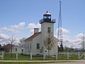
The Sand Point Lighthouse is a story-and-a-half rectangular building with an attached brick tower. The tower is topped with a cast iron lantern room which houses a fourth order Fresnel lens, emitting a fixed red light with a radiating power of 11.5 miles (18.5 km). A unique distinction concerning the Sand Point Lighthouse is that it was constructed with its tower facing the land instead of facing the water. Whether this orientation was intentional or an engineering blunder is unknown.

John Terry was appointed the first lighthouse keeper of the new lighthouse in December 1867, but he became very ill and died in April 1868 a month before the lighthouse was ready to be manned. With the lighthouse nearly completed but with no lightkeeper ready to report to duty, John Terry's wife, Mary, was appointed lightkeeper and subsequently became one of the first female lightkeepers on the Great Lakes. Mary Terry was a well-respected citizen in the community and fulfilled her duties as lightkeeper with efficiency and dedication. She was lightkeeper from 1868 to 1886, when a mysterious fire severely damaged the lighthouse [13] and took her life. To date, no one knows exactly what happened or why it happened. Some speculate that it was an attempted burglary and that the suspect set the lighthouse afire to cover any evidence of wrongdoing. The south entrance door showed signs of forced entry, yet none of Mary Terry's valuables were taken. With the lighthouse badly damaged, restoration took nearly two full months and a new lightkeeper, Lewis Rose, was appointed to take over. [14]

Over the years a number of changes took place at the Sand Point Lighthouse. Perhaps the most significant was when the lighthouse was hooked up to the city's electric supply in 1913. This meant that the kerosene lamp was removed from within the lens and replaced with an incandescent light bulb.

The Coast Guard years

Sand Point Lighthouse postcard Sandpoint8.jpg
Sand Point Lighthouse postcard

A total of nine lightkeepers and their families lived in the Sand Point Lighthouse from its inception in 1868 to its deactivation in 1939. It was in this year that the United States Coast Guard took over all navigational lights in the country from the National Lighthouse Service. The Coast Guard constructed an automated crib light several hundred feet offshore, which replaced the function and duties of the Sand Point Lighthouse and its lightkeeper. The automated crib light is still in use today and can be seen from the tower of the Sand Point Lighthouse.

The Sand Point Lighthouse was no longer operational, but it continued to serve as housing for Coast Guard seaman who were assigned to duty in Escanaba. Upon using the lighthouse as their residence, the Coast Guard made many changes to the structure. The lantern room was removed and the tower was lowered by ten feet. In addition, the roof was raised to create a full second floor, several windows were added and the entire building was covered in aluminum siding. With these changes, the Sand Point Lighthouse was barely recognizable.

Restoration

Sand Point Lighthouse Sandpoint3.jpg
Sand Point Lighthouse

The U.S. Coast Guard occupied the building until 1985 when they moved to a new location. The abandoned lighthouse was then obtained by the Delta County Historical Society in 1986 with plans to restore it back to its original appearance. With the help of the original 1867 plan of the building, the Delta County Historical Society began extensive research and fundraising for this immense restoration project. The historical society first removed the aluminum siding to expose the original brickwork. The roof was lowered to its original level, the new windows were bricked-in and the ten foot lopped-off tower was rebuilt. Since the original lantern room and lens were not salvaged, the historical society had to look elsewhere for replacements. They found a lantern room on nearby Poverty Island which had been removed from the Poverty Island Light Station there and was sitting on the ground next to the tower for nearly a decade. [15] In 1989, along with the lantern room, a fourth order fresnel lens was obtained from the Menominee Pier Light, both of which were nearly exact duplicates of the originals that once sat atop Sand Point Lighthouse and the lens was replaced. [4] A photo of the installed Fourth Order Fresnel lens is available. [16] To finish the restoration, the lighthouse was painted white and the interior space was restored and furnished as a turn of the 20th century replica. [17]

After a dedication ceremony in July 1990, the newly restored Sand Point lighthouse was opened to the public. Each year the lighthouse is open from Memorial Day to October 1, giving visitors a chance to climb the tower and witness what it would have been like to be a lightkeeper around the turn of the 20th century. [17] An admission fee is charged.

The light is listed on the National Register of Historical Places, Reference #97001474. Name of Listing: Sand Point Lighthouse. It is also on the state inventory list, beginning in 1989. [2]

See also

Related Research Articles

<span class="mw-page-title-main">Point Iroquois Light</span> Lighthouse in Michigan, United States

Point Iroquois Light is a lighthouse on a Chippewa County bluff in the U.S. state of Michigan. Point Iroquois and its light mark the division line between Whitefish Bay and the western end of the St. Marys River, the connection between Lake Superior and other Great Lakes.

<span class="mw-page-title-main">Whitefish Point Light</span> Lighthouse on the Upper Peninsula of Michigan, United States

The Whitefish Point Light is a lighthouse located in Chippewa County in the U.S. state of Michigan. Located on the southeastern shores of Lake Superior, it sits at the edge of Whitefish Point leading to Whitefish Bay. Constructed in 1849, it is the oldest operating lighthouse in the Upper Peninsula. All vessels entering or exiting Lake Superior pass near Whitefish Point. The area is infamously known as the "Graveyard of the Great Lakes" due to the high number of shipwrecks in the area, most famously the SS Edmund Fitzgerald.

<span class="mw-page-title-main">DeTour Reef Light</span> Lighthouse in Michigan, United States

The DeTour Reef Light is a non-profit-operated lighthouse marking the southern entrance of the DeTour Passage between the eastern end of Michigan's Upper Peninsula and Drummond Island. The light is an automated active aid to navigation. It marks the northern end of Lake Huron. The passage is used by almost all of the Great Lakes commercial freighter traffic moving to and from Lake Superior, with approximately 5,000 vessel movements annually. It is said to be "the gateway to Lake Superior." In addition, many recreational boaters use the passage. The Light is located in Lake Huron, three miles (5 km) south of the nearest town, DeTour Village, Michigan.

<span class="mw-page-title-main">Charity Island Light</span> Lighthouse in Michigan, United States

Charity Island Light is a lighthouse on Big Charity Island in Lake Huron just off the coast of Au Gres, Northern Michigan.

<span class="mw-page-title-main">Old Mackinac Point Light</span> Lighthouse in Michigan, United States

Old Mackinac Point Light is a deactivated lighthouse located at the northern tip of the Lower Peninsula in the U.S. state of Michigan. The lighthouse is part of Fort Michilimackinac State Park in the village of Mackinaw City just east of the Mackinac Bridge.

<span class="mw-page-title-main">Saginaw River Rear Range Light</span> Lighthouse in Michigan, United States

The first Saginaw River lighthouse was constructed from 1839 to 1841, in a period when large quantities of lumber were being harvested and shipped from the heart of Michigan via river and the Great Lakes to the East Coast of the United States via the Erie Canal and Hudson River. This connection to major eastern markets was critical to the development of central Michigan.

<span class="mw-page-title-main">Sturgeon Point Light</span> Lighthouse in Michigan, United States

The Sturgeon Point Light Station is a lighthouse on Lake Huron in Haynes Township, Alcona County, northeastern lower Michigan. Established to ward mariners off a reef that extends 1.5 miles (2.4 km) lakeward from Sturgeon Point, it is today regarded as a historic example of a Cape Cod style Great Lakes lighthouse.

<span class="mw-page-title-main">Au Sable Light</span> Lighthouse in Michigan, United States

Au Sable Light is an active lighthouse in the Pictured Rocks National Lakeshore west of Grand Marais, Michigan off H-58. Until 1910, this aid to navigation was called "Big Sable Light".

<span class="mw-page-title-main">Milwaukee Pierhead Light</span> Lighthouse

The Milwaukee Pierhead Light is an active lighthouse located in the Milwaukee harbor, just south of downtown. This aid to navigation is a 'sister' of the Kenosha North Pier Light.

<span class="mw-page-title-main">Milwaukee Breakwater Light</span> Lighthouse

The Milwaukee Breakwater lighthouse was built in 1926 in the harbor of Milwaukee in Milwaukee County, Wisconsin to mark the entrance to the harbor. One of the last fully enclosed breakwater lighthouses in the Great Lakes, the structure was placed on the National Register of Historic Places in 2011.

<span class="mw-page-title-main">Little Sable Point Light</span> Lighthouse in Michigan, United States

The Little Sable Point Light is a lighthouse located south of Pentwater in the lower peninsula of the U.S. state of Michigan. It is in the southwest corner of Golden Township, just south of Silver Lake State Park.

<span class="mw-page-title-main">Menominee Pier Light</span> Lighthouse in Michigan, United States

The Menominee North Pier lighthouse is located in the harbor of Menominee, Michigan. The station was first lit in 1877. The current structure and its still operational light was lit in 1927, and automated in 1972. It is also sometimes called the "Menominee (Marinette) North Pierhead Light".

<span class="mw-page-title-main">Peninsula Point Light</span> Lighthouse in Michigan, United States

The Peninsula Point Light is a lighthouse located at the southern tip of the Stonington Peninsula in Bay de Noc township in Delta County, Michigan. United States Coast Guard historical documents have over the years listed the name of the site as both Peninsula Point and Point Peninsula.

<span class="mw-page-title-main">White Shoal Light, Michigan</span> Lighthouse in Michigan, United States

The White Shoal Light is a lighthouse located 20 miles (32 km) west of the Mackinac Bridge in Lake Michigan. It is an active aid to navigation. It is also the tallest lighthouse on the Great Lakes.

<span class="mw-page-title-main">Harbor Beach Light</span> Lighthouse in Michigan, United States

The Harbor Beach Lighthouse is a "sparkplug lighthouse" located at the end of the north breakwall entrance to the harbor of refuge on Lake Huron. The breakwall and light were created by the United States Army Corps of Engineers to protect the harbor of Harbor Beach, Michigan, which is the largest man-made freshwater harbor in the world. Harbor Beach is located on the eastern edge of the Thumb of Huron County, in the state of Michigan.

<span class="mw-page-title-main">Port Sanilac Light</span> Lighthouse in Michigan, United States

Port Sanilac Light is a United States Coast Guard lighthouse located on Point Sanilac, near Port Sanilac on the eastern side of Michigan's Thumb. It is an automated and active aid to navigation on Lake Huron.

<span class="mw-page-title-main">Marquette Harbor Light</span> Lighthouse in Michigan, United States

The Marquette Harbor Light is located on Lake Superior in Marquette, Michigan, a part of the Upper Peninsula. It is an active aid to navigation.

<span class="mw-page-title-main">Fourteen Foot Shoal Light</span> Lighthouse in Michigan, United States

The lighthouse at Fourteen Foot Shoal was named to note that the lake is only 14 feet (4.3 m) deep at this point, which is a hazard to navigation, ships and mariners.

<span class="mw-page-title-main">Gull Rock Light Station</span> Lighthouse in Michigan, United States

The Gull Rock Light Station is an active lighthouse located on Gull Rock, just west of Manitou Island, off the tip of Michigan's Keweenaw Peninsula in Lake Superior. The light was listed on the National Register of Historic Places in 1984, even as its condition deteriorated, resulting in its placement on the Lighthouse Digest Doomsday List.

<span class="mw-page-title-main">Grand Island Harbor Rear Range Light</span> Lighthouse in Michigan, United States

The Grand Island Harbor Rear Range Light is a lighthouse located off M-28 in Munising Township, Michigan. It is also known as the Bay Furnace Rear Range Light, Christmas Rear Range Light, or End of the Road Light. The corresponding front range light was replaced in 1968; the rear range light was listed on the National Register of Historic Places in 1990. It is no longer an active aid to navigation.

References

  1. 1 2 Amateur Radio Lighthouse Society.
  2. 1 2 National Park Service, Maritime Heritage Project, Inventory of Historic Lights, Sand Point Light.
  3. Pepper, Terry. "Database of Tower Heights". Seeing the Light. terrypepper.com.
  4. 1 2 3 Michigan Lighthouse Conservancy, Sand Point (Escanaba) Light.
  5. "Historic Light Station Information and Photography: Michigan". United States Coast Guard Historian's Office. Archived from the original on 2017-05-01. Sand Point (Escanaba) Light
  6. Pepper, Terry. "Database of Focal Heights". Seeing the Light. terrypepper.com.
  7. 1 2 Lighthouse depot, Sand Point (Escanaba) Light.
  8. 1 2 Light List, Volume VII, Great Lakes (PDF). Light List. United States Coast Guard.
  9. 1 2 3 Rowlett, Russ. "Lighthouses of the United States: Michigan's Eastern Upper Peninsula". The Lighthouse Directory. University of North Carolina at Chapel Hill.
  10. "National Register Information System". National Register of Historic Places . National Park Service. March 13, 2009.
  11. Michigan Atlas and Gazetteer (10th ed.). Yarmouth, Maine: DeLorme. 2002.
  12. Lighthouse Central, Sand Point Light (Escanaba), The Ultimate Guide to Upper Michigan Lighthouses by Jerry Roach. (Publisher: Bugs Publishing LLC - 2007). ISBN   978-0-9747977-2-4.
  13. Interactive map on Michigan lighthouses. Detroit News
  14. "Mason, Kathy S. Mystery at Sand Point Lighthouse, Michigan History Magazine, September/October 2003". Archived from the original on 2009-01-05. Retrieved 2008-10-13.
  15. Wobser, David, Sand Point Light (Escanaba), boatnerd.com.
  16. A photo of the installed Fourth Order Fresnel lens at Terry Pepper, Seeing the Light, Terry pepper.ocm
  17. 1 2 Terry Pepper, Seeing the Light, Sand Point Lighthouse, Escanaba, Michigan.

Specialized further reading